Category Archives: Haze County

BM Urban Landscape 07/25/15 06

Looking back at the western end of the ALO trail. A faint path, yes.

IMG_0171smaller

We now walk down Willard Street, departing from Leola Creek for a spell until nearing Point+1 on our BMUL map. LINK This meadow is a historic site along the way, once containing a basketball court where 3 men from a nearby cafeteria gathered together to pit wits and shots against each other. I was one of these men.

IMG_0174smaller

Willard Street is named for the Willard House, former home to another one of these men and not to be confused with George Willard from Sherwood Anderson’s Winesburg, Ohio. But sometimes one forgets.

The third man on our team was sometimes referred to as Col. Z. A handful might have called him Chuck, like in Charlie Brown of Peanuts fame. He wore brown a lot, true. He was also known as a Zapper, a basketball term.

IMG_0177smaller

Willard Street merges into the main road through the area after rounding a curve, but it is at this curve we instead depart from the pavement and keep heading straight toward more commercial buildings, one of which houses the office of my dentist of 20 years. I call this interesting grassy pool behind his office Canine Pool, named not for dogs but teeth.

A stubbier matching depression around the corner becomes Molar Pool (not pictured), currently dry.

IMG_0180smaller

IMG_0181smaller

We then pass a commercial storage company, with this mysterious fallen pillar crushing some vegetation at the main gate. Remnants of a fallen Blue Mountain empire?

IMG_0184smaller

A cluster of rocks on the west edge of same I call the “Stonehenge” of the Blue Mtn. Urban Landscape, but that’s quite a stretch obviously. We’ll see what develops of it. It’s actually “mere” buttressing rocks around another culvert area.

IMG_0186smaller

This is part of the same drainage system. I don’t quite get why this system was designed so elaborately — almost Romanesque in flavor. Hmm.

IMG_0187smaller

We’ve reached Leola Creek and that perching 6 sided picnic table again in moving inextricably closer to Point+1, which draws us like a magnet.

IMG_0189smaller

Leave a comment

Filed under Blue Mountain

BM Urban Landscape 07/25/15 05

Up we go and out from under the Point-0 bridge centering the Blue Mtn. Urban Landscape. But this is a small hill, and we’ll still be trekking on basically level ground for the second part of our looped trail.

IMG_0139smaller

The paved trail continues to parallel Leola Creek as we travel past large hemlocks to our right, and with yet another commercial building full of shops and offices hemming us in on our left. This is one of my favorite parts of the journey. I feel safe here.

IMG_0140smallest

IMG_0141smaller

You can peer through breaks in the wall of hemlocks at a car wash across the creek. I caught this guy sitting on a fence with his back to me, looking at another working much harder in removing car filth and such.

IMG_0143smaller

The official trail terminates with the simultaneous end of the hemlock row and commercial building, about 200 yards past the central bridge. From there we can cross a road the trail merges into and take a shortcut through the edge of a public garden space, still hiking parallel to Leola Creek. There’s even an access path to the creek off this side trail, the first such on our journey. Below is the small beach area you find at the creek…

IMG_0155smallest

… with a central reddish rock for viewing and contemplating. Nice.

IMG_0159smaller

Large willow encountered as we continue past the garden. Here we have several options. We can head back to the main road, a busier one leading to a local HugeMart, and take the first street to the right at the intersection — or we can take a *secret* trail through what I’m calling ALO and remain beside Leola Creek, cutting our distance in at least half to the same point, and also avoiding traffic congestion completely. The drawback: this *ALO* trail, while obviously used by others *at times*, seems to be on private land according to online real estate maps. It’s a pretty faint path as well, and I found a little poison ivy/oak to dodge along it. Nothing that can’t be successfully navigated without contact, however.

IMG_0163smaller

This time I decided to stick to the road. Here’s a nice array of colors from the same flower species (which one?) poking over a border fence.

IMG_0167smaller

Taking that right I mentioned before at the next intersection brings us to the place where we’d come out on the AOL path anyway, which is approximately the location of the interesting forked parking spaces seen below, tucked away from the main street in a white pine grove.

IMG_0169smaller

A water culvert on the same property. Directly behind it here is the road we take to reach the west end of the Blue Mtn. Urban Landscape, or Point+1 on our map.

IMG_0170smaller

Leave a comment

Filed under Blue Mountain

BM Urban Landscape 07/25/15 04

Graffiti found underneath the bridges at Point-1. It seems mysterious… meaningful in some manner.

IMG_0090smaller

I believe this blue hued glyph represents a lantern. Strangely, the rust colored mark beside it gives the appearance of a flame, or something like an erupting volcano perhaps. The amorphous blue spot above it to the left, likely a mistake made by the graffitist who painted the lantern, seems to counterbalance it in a hot-cool fashion. I think back to the joined red-blue tables here at Position+1 on the very opposite side of the Blue Mtn. Urban Landscape. Is there a direct synchromystic linkage going on here? Could very well be(!).

IMG_0091smaller

Vegetation bordering Leola Creek out past Point-1. We’re in the country now, and the number of walkers and bikers has significantly increased. Ugh. But it wasn’t too bad this day.

IMG_0098smaller

Shortly the trail forms a loop, the western part which follows Leola Creek to its mouth where it flows into another, larger creek, still unnamed as of this date.

IMG_0105smaller

Peering through trees toward the Leola Creek mouth. Bemusing orange light appears between tree trunks.

IMG_0114smaller

Wow, a deer right next to the trail (!). Just stared at me as I passed, and even allowed me to stop and take a picture without running away.

IMG_0116smaller

Back safe and sound inside the Blue Mtn. Urban Landscape now, having survived the trip into Hiker/Bikerland. I revisit the picnic table near Point-1, and refresh myself by staring down at the creek a bit.

IMG_0131smaller

Artificial plants in a window box in front of the building that this table lies behind. Red and blue (hot and cold) again.

IMG_0132smaller

Back at near the center of the Urban Landscape, where our first pictures were taken in this series. “Bridge violators will be arrested for… thanken”?

IMG_0136smaller

Trail just west of the central bridge.

IMG_0137smaller

1 Comment

Filed under Blue Mountain

BM Urban Landscape 07/25/15 03

We’re back on the main trail, continuing to head east.

IMG_0078smaller

It’s not really a trail past the wetland but more a bike lane connecting two parts of the trail. I was mildly disappointed that the tar squiggles on the road here didn’t show up on GoogleEarth for further scrutiny. The wife commented favorably on them too when she walked this part of the Urban Landscape with me weekend before last.

IMG_0079smaller

Good deed for the day: I removed this nail from the road and deposited it in a handy nearby dumpster.

IMG_0080smaller

A toothbrush was laying on the ground next to the dumpster.

IMG_0081smaller

We take a little side trek here to keep following Leola Creek north and west behind yet another commercial building. I captured the flight of a crow above the rooftop of the neighboring building.

IMG_0083smaller

Rounding the corner, we spot the entrance to yet another Urban Landscape “picnic area”.

IMG_0084smaller

Interesting nearby door. Entrance to a parallel dimension? (probably not)

IMG_0085smaller

I see this place overlooking Leola Creek, close to Point -1 on our map, as perhaps a balance to similar tables positioned around Point +1 on the other side of the BMUL, or the 6 sided table and the conjoined red and blue tables featured in this earlier post, and which are both found next to Leola Creek in that westward position.

IMG_0087smaller

This confluence of bridges, walking and driving, probably represents the actual position of Point-1 at the eastern tip of our Blue Mtn. Urban Landscape. But this day I decided to follow the official trail further, out in the country a bit.

IMG_0088smaller

1 Comment

Filed under Blue Mountain

BM Urban Landscape 07/25/15 02

We temporarily exit the greenway system past the wetlands and bridge pictured before, heading up a side road instead leading to the main highway of the Blue Mountain commercial strip. In the below picture we look up a side road off this side road toward a community hospital. The hospital is not directly on our Urban Landscape beat, however. Not yet anyway.

IMG_0064smaller

About a 100 yards down the same road brings us to this ambulance service building with fronting, cattail dominated wetland, smaller in dimension than the one across the road just passed.

IMG_0065smaller

The main strip. We will only briefly travel beside it…

IMG_0066smaller

… quickly taking a turn into a Holiday Inn.

IMG_0067smaller

Behind this place, we can walk parallel to the side road just traveled, a marshy brook dividing us from it.

IMG_0068smaller

Soon we run across this picnic area also wedged between the two.

IMG_0071smaller

Looking from this area back up the stream. More cattails. My apologies for the overexposed background.

IMG_0074smallest

Then we use the Lowes Grocery Store backlot from here to connect with the Leola Creek paved trail again, emerging from the border bushes near the rusty bridge beside the larger wetland we saw before.

IMG_0075smaller

More interesting objects found behind Lowes. Trinkets of the urban landscape.

IMG_0076smaller

IMG_0077smaller

Leave a comment

Filed under Blue Mountain

BM Urban Landscape 07/25/15 01

In our more detailed tour of the Blue Mountain Urban Landscape, we appropriately start at point “0” according to this map. We are going to move in a general direction from “0” east to “-1”, and then back west through “0” to “+1”, then return. In other words we are doing a type of loop sort of centered around “0”, with extremities of “-1” and “+1”. Kind of.

The photo below starts us under the bridge at “0” It is against the law to loiter here so I moved on quickly after taking a couple of snapshots.

IMG_0032smaller

These rocks across Leola Creek give off a vague Wiltshire vibe in their sarsen-like appearance. Compare to stones from the later, for example, in collage 02 of 2013’s Latona series. There is a possibility that Master Shake could reappear here at Point Zero, inspired by the resonance.

IMG_0035smaller

Another version of a drink, wedged in the branches of a rhododendron. Empty. Appears to be too expensive of a beer for possible homeless bridge people. Are there such people?

IMG_0037smaller

From Point Zero halfway to Point -1, we walk along a registered paved trail, a type of greenway. But it isn’t as busy as some parts lying just north and west of the official Blue Mtn. Urban Landscape. Lying north and west of Point -1, in other words.

The below photo finds us peering through green vegetation toward the back of a restaurant on the other side of Leola Creek. Every time I’ve walked by here music has been pouring from the place — Latin music I believe. A bag lies in the branchs of a nearby bush. I’m scared to examine it closer.

IMG_0038smaller

Trail heading west. To the right exists a Lowes Grocery Store and its vast parking lot. To the left is vegetation bordering Leola Creek.

IMG_0039smaller

A defaced birch tree. NS, HC and CS should be ashamed of themselves.

IMG_0040smaller

A break area probably used by Lowes employees. It has been designed as a memorial to a man named Steve D., perhaps a past employee of some note. I’ll have to do more research on that.

IMG_0049smaller

Continuation of the wall westward. Lots of robins in the vicinity. Suppose I could call this Robin Wall or Robins’ Wall, then.

I’ve also found who Steve D. is. Former store manager. Native of Michigan.

IMG_0051smaller

Contrasting neighboring sewer covers. One grassy, one not.

IMG_0053smaller

Interesting wetlands next to a trail bridge.

IMG_0059smaller

1 Comment

Filed under Blue Mountain

Urban Landscape 01

Map of Blue Mountain Urban Landscape, my new hiking focus.

ALO02

More interesting picnic table on the western side, near position “+1” on the map.

IMG_0019smaller

Just across the stream we have a geodesic dome church. The table seems matched to the shape of the structure. Interesting collection of rocks near the stream bank here as well. What is the stream name? I know the name in Real Life. What is it in this blog? I’m going to call it Leola Creek for now (not Bristle Creek).

IMG_0022smaller

More picnic tables, matched to themselves this time, and even closer to position “+1” on the above map. I think they might refer to conjoined positive and negative poles of a magnet. Is the Blue Mtn. Urban Landscape itself a magnet?

IMG_0026smaller

33543-bar-magnet-120x22x10mm

If the central creek’s name running between “+1” and “-1” in the landscape is Leola, then this is a pivotal point on it called ALO, a related term.

IMG_0027smaller

ALO is composed of a secret, hidden trail next to Leola Creek. Turning away from the creek while standing in place brings this additional, mysterious structure into view. Could it possibly be the skeleton of another geodesic dome? Seemingly we have reached True Center.

IMG_0028smaller

Sunday as I walked the landscape with my wife, I joked to her that I wanted to buy the property adjacent to ALO where this mysterious wooden skeleton is found. She half believed me, and actually got a little upset about it. I believe it 1/3rd myself, which is something.

2 Comments

Filed under Blue Mountain

Whitehead X-ing Birthday Visit

TEXT SOON.
IMG_0009smaller

IMG_0010smaller

IMG_0011smaller

IMG_0016smaller

IMG_0017smaller

Leave a comment

Filed under Frank Park, Whitehead Crossing

I guess…

… I’ll always have Whitehead Crossing now, Hucka D. The tiny cemetery there is Wilcoxson. Sorry: Dogpatch. There’s only one Wilcoxon and that’s Dogpatch[ in GNIRPS]. I’ll always have a portal to WH X-ing.

rainbowmenexcerpt01

collage05test07

Leave a comment

Filed under Frank Park, Whitehead Crossing

Collage 11 Interpretation 02 > Collage 12

(continued from)

rainbowmenexcerpt04
“Rainbow Men” excerpt: beer drinking Jackalope

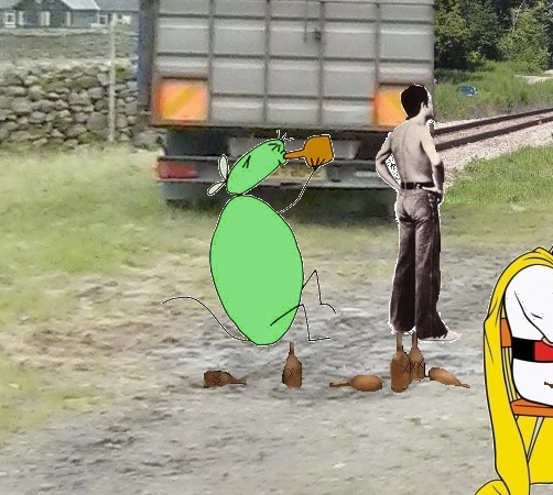
This central image from Collage 11 is obviously akin to 12 Oz Mouse from the first collage of the tetraptych, or “Animation Nation”. Both are multiple beer drinking animals of “X Brand” variety…

fitz01
“Animation Nation” excerpt: beer guzzling 12 Oz Mouse

12 Oz Mouse is also found in the 3rd collage of the tetraptych (“Holey”), leaning over to stare at a hole. He leans the opposite way there from a drinking position. Is he sobering up instead? Seeing the hole that is his life as an alcoholic rodent?

Anyway, another thing to remark about is that the left part of the jackalope image above is cut off on the *center line* of Collage 11. Likewise 12 Oz Mouse’s hole is cut in 2 by the left edge of Collage 10 before this. The effect helps further unite the 2 characters.

The jackalope, or at least his head (her head?), has made one other appearance in my collages that I recall, and we’ve already reviewed it a bit in the last post here: Sam Parr 09. I’ll throw up the picture again. Or insert it in this post again, I mean.

samparr10test07h

And Karoz again appears in a collage with this animal. The jackalope wears the body in Collage 11, as it were, of Sam Parr Model (SPaM). The blue robot of the red-blue-7 Stones pairing perches on her shoulder. The antlers make a shape similar to that of Sam Parr Lake, whose outline appears in the center of Collage 10 (blue, coral like growth sprouting from wall vegetation). So the jackalope represents Sam Parr in multiple forms. The Falmouth Rabbit appears in the landscape below it, the central figure of Collage 11 and the focus. A smaller Karoz’s head indicates it by pointing and mirroring. In drafts of Collage 11, I had this little Karoz appearing on the foot of the drinking jackalope. Now the larger image of Karoz is all that’s left, but in both parts of the animation and in two different positions. He appears to fall from the wall, originally held by the cartoon homeless man from Aqua Teen, but somehow also turning around in the fall to “land” on his head, which is the same as the head of Scatman Cruthers at the foot of the wall. A surreal impossibility in other words — collage liberties. Much like a giant and small Karoz appear together in that Sam Parr collage: perspective distortion there.

The orange bottle and also the orange squares on the back of the truck behind him reinforce the association of 12 Oz Mouse in “Animation Nation” with the central orange jackalope in Collage 11. The orange is also reinforced in the multiple Meatwads in the same collage, but, moreover, the orange m&m to his above right, the one watching the Fall of Dorothy from the White House. Another resonance with the Meatwads is accidental: Part of his antler was cut off when I edited the overall animation — this would be in part 2. I left the mistake in because it seems to mirror Meatwad’s “hand” *extending* from his body in part 2 and touching Shake, simultaneously turning him into a Rainbow Man himself.

“Are we done with this one Hucka D.?”

—–

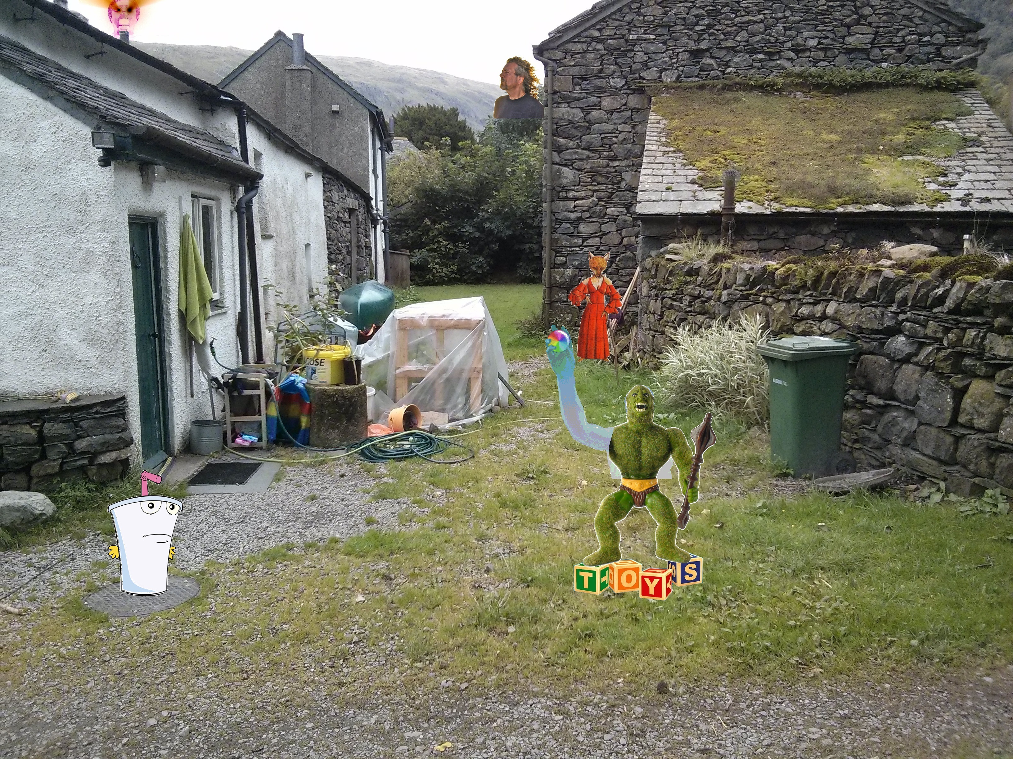
Since Hucka doesn’t seem to be around this morning let’s assume we are and move into Collage 12, which is the last one of the Stonethrow series and called “Triumph of the Toys”. The Red Fox appears again, just like she did in Sam Parr 10 (coming after Sam Parr 09 just discussed above). This is probably a Peter Gabriel image again, balancing his appearance in the first collage of the tetraptych perhaps: Lamb Lies Down on Broadway’s character Rael, as opposed to Foxtrot’s anthropomorphized fox here. This fox represents an endpoint. The music from the album Foxtrot is used in a more recent synch I’ve named Carrcass-6. This carrcass also features video excerpt from 12 Oz Mouse, some of which is dubbed by the Foxtrot music.

collage12atest08

Here we have part 1 of the two part animation that is “Triumph of the Toys”… there’s the red fox I’m speaking about against a rock wall in the mid-ground. Almost beside her is a green mossman with scepter in left hand. Above him is a giant Robert Plant of Led Zeppelin fame, head against the sky. He’s staring at another sky head, golden in color but about to turn red and erupt, as it were. A row of toy blocks is arranged in the foreground, spelling TOYS itself. Master Shake again looks on from the right, but he appears to be asleep in part 1.

collage12btest11

In part 2 he appears to be jolted awake by Mossman, who has continued to move forward and is now standing on the toy blocks. His *right* arm has become transparent and extending, holding a multi-chromatic ball *triumphantly*. This is the triumph of the toys (whatever that really means). Hucka D. is still not here to help me. I’m going to make some guesses.

We’ve mentioned that the red fox of the present collage is also found in the last collage of the Sam Parr series also found in The Red Umbrella gallery: Sam Parr 10. Last collage reflects last collage in this way. And I’m also thinking there’s another resonance: I believe the fact that the 4 colors of TILE are found in that pile of objects that Mossman passes to his right on his way to the toy blocks — red, green, blue, yellow — also allows us to tie this into Sam Parr 10 in the similar 4 colors of TILE making up the stage to the left.

samparr10teset02b
Sam Parr 11: “The Stage” (part 2 of 2 part animation)

In particular, I believe the wooden shelves or whatever they are, covered in plastic in “Triumph” can be paralleled with the tiny studio appearing on this TILE surrounded stage in the Sam Parr collage. Does the passing Mossman then equal The Master’s charismatic religious figure Lancaster Dobb (source image for Sam Parr 11)? And does he champion TILE instead of The Cause, if so? The ball he triumphantly holds high in the air contains all the TILE colors in one, chromatic whole. His scepter has been switched from right to left hand in the process. The eyes in the formerly golden head of the far background, high on the mountains apparently, have erupted redness like a volcano. What is the triumph? Obviously this has something to do with the story of Mossman Gene Fade of Frank and Herman Parks. I don’t think Mossman appears in any of the other collages in the Red Umbrella, although he is found in other Collagesity gallery works.

Where does this Mossman get the ball? Did the fox pass it on to him? Or does it represent the TILE colored pile of objects he also passes by in moving from mid-ground to foreground? We have more questions than answers here. Why am I not surprised. We’ll have to wait until Hucka D. wakes up much later on to further our investigation, if needed.

(continued in?)

1 Comment

Filed under collages 2d, Lake District, Mossmen, Toy Avatars, United Kingdom