
Yes, you read that correctly. Those dark, wrinkled fruits found on the grocery shelves next to raisins and dried apricots can improve your bone density!
Related:
http://www.amazon.com/Introducing-Lemon-Cheer-Accident/dp/B0000C0FLF
Yes, you read that correctly. Those dark, wrinkled fruits found on the grocery shelves next to raisins and dried apricots can improve your bone density!
Related:
http://www.amazon.com/Introducing-Lemon-Cheer-Accident/dp/B0000C0FLF


“Does the Baker Blinker Blog’s Baker’s Island (i.e., Henry Island; post 1 of 2233 post blog) merely act as a pointer to Rhode Island’s Block Island?” Is the 1st post or base post of the follow-up “Baker Bloch Blog” (“Frank and Herman, Einstein!” at bakerbloch.wordpress.com) not the literal 1st post in this case but one hidden *within* the blog itself, at its 3-dimensional center?
Hucka D.:
You can use the island [Bloch Island] to travel to other dimensions. See yourself as extraterrestrial or extradimensional and try it out.
—–
http://www.apricot.com/~jimcat/pictures/blockisland/stuff.html


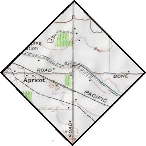
Laterally, Apricot Road is only road between King Tull Road and Johnson Road on the map just above, halfway between the 2. Apricot Rd. then equates w/ the (blocked) Hinzerling Road mentioned in the 05/11/82 Tri City Herald newspaper article. Apricot.com directly bridges Block Island rock cairns with Sunfish Pond rock cairns.
If you leave out the “c”, apricot is an anagram of airport. Apricot has no one word anagrams.
The only 2 word anagram of “apricot” according to this web site, is “a tropic”. Apricot is a tropical fruit.
King Tull refers to rainbowology, SID’s 1st Oz, and King Tull as coupled partner to (Queen) Queen.
Filed under Canada/Tungaska, MAPS, Rhode Island, Washington
Water obelisk from Runescape:
http://misc.thefullwiki.org/Water_Obelisk

http://runescape.wikia.com/wiki/Water_Obelisk_Island
Compare:

—–
Looking up other Pietmond related names in atlases and came across SoSo Springs in Brewster County, Texas, more commonly known as Pena Blanco Springs. This appears to be the only significant place named Soso outside those directly connected with the Soso, Mississippi village. Quite amazing: a swimming pool formed from the spring waters was the landing spot of a 150+ lb. meteorite in 1946. Article here:
http://www.minsocam.org/ammin/AM32/AM32_354.pdf
INrnooucrtoN
As far as known, man has never constructed a device in which to trap
a meteorite falling to the earth. Had he done so, possibly he could not
have improved upon the swimming pool at the headquarters of the Gage
ranch about 9.5 miles southeast of Marathon in Brewster County, Texas.
This swimming pool received the Pefla Blanca Spring meteorite with a
violent splash at about 1:20 p.u. on August 2, 1946. The meteorite is
named from the spring which forms the swimming pool and which is
an historic landmark in the region. The exact location is longitude
103″7.l’ west longitude 3007.5′ north latitude. The unusual location of
the fall, the fact that the meteorite fell within a few hundred feet of
twenty-four people, and its unusual petrographic character appear to
warrant a fairly complete account….
http://www.encyclopedia-of-meteorites.com/meteorite.aspx?id=18786

—–
Hmmm, well we can go several directions in Pietmond storytelling with this one. First off, Obelisk Pond is the site of a *meteor or meteorite fall*, and the obelisk represents the meteor itself, or marks the location of the fall. Perhaps the falls behind the pond represent the fall of the meteorite. Like the Pena Blanco Springs meteor, our Pietmond meteor, perhaps nicknamed SoSo, fell into this body of water on the western edge of the village. Perhaps it created the pool in the first place. Or it could have been so large that the obelisk was made from it, or at least the obelisk *contains* the meteor or meteorite in some way. I also think back to a realtor I was renting from in Aotearoa who jokingly said to me that all these sinks in the area, including the Aoteaora Sink we were jointly staring into at the time, were perhaps created by meteors. Did the SoSo Meteor create the Pietmond sinkhole itself?? A possibility (!)
http://www.meteorite.com/meteorite-gallery/meteorite-pages/Pena_Blanca_Spring.htm
Might even have some kind of SoSo Meteor gallery based on the pictures in that page linked to above.
—–
http://en.wikipedia.org/wiki/The_Paradise_Syndrome
Meanwhile, over the two-month journey back to the planet, Spock works on the translation of the obelisk’s symbols. He theorizes the obelisk may have been placed on the planet as an “asteroid deflector” built by the ancient Preservers who are believed to have seeded the galaxy with humans, particularly groups that may have been in danger of dying out thousands of years ago. The asteroid deflector was designed to protect them in a high-risk star system. Spock concludes that the device has ceased to work properly. Spock determines that the only hope of saving the planet is to somehow activate the deflector. He eventually realizes that the symbols aren’t words but musical notes; a possible activation code of some kind.
So with this new tie-in, perhaps the obelisk of Pietmond likewise deflects asteroids, perhaps put in place after the original asteriods created the Sunklands sink. Or it may be a model of an original, larger meteor-deflecting obelisk. Words as musical notes…. interesting.
Also interesting is this conjunction of names in Washington state:

Filed under **VIRTUAL SL, Jeogeot, MAPS, Pietmond-, Sunklands, Texas, Washington
