Category Archives: Haze County

Red Head + Greenhead 02

As I’ve spoken about before, the problem with the name Red Head is that it lies on (and near the source or head of) *Green* Stream, while it is Greenhead instead positioned on the smaller tributary of Green Stream named Red, probably Red Brook or Red Spring. Obviously there’s a bit of a switcheroo happening here. I think of color-blind people who can’t differentiate the colors green and red.

colorblind

According to Whitehead X-ing mythology, Red Head was named for Leaf Erik’son’s father’s red hair. In the real world, the source of of these 2 Whitehead X-ing figures are famed Norse explorers Leif Ericson and his own carrot topped father Erik The Red.

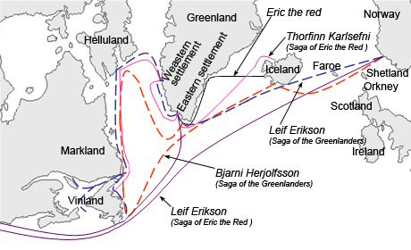
Thorvald Asvaldsson [Erik the Red] was banished from Norway for manslaughter and went into exile in Iceland accompanied by young Erik [Leif]. When Erik was himself banished from Iceland, he traveled further west to an area he named Greenland, where he established the first permanent settlement in 986….

Erikson and his crew travelled from Greenland to Norway in 999. Blown off course to the Hebrides and staying for much of the summer, he arrived in Norway and became a hirdman of King Olaf Tryggvason. He also converted to Christianity and was given the mission of introducing the religion to Greenland.[13][17] The Saga of Erik the Red and the Saga of the Greenlanders, both thought to have been written around 1200,[18] contain different accounts of the voyages to Vinland.[19][20] The two only known strictly historical mentions of Vinland are found in the work of Adam of Bremen c. 1075 and in the Book of Icelanders compiled c. 1122 by Ari the Wise.[21] According to the Saga of Erik the Red, Leif apparently saw Vinland for the first time after being blown off course on his way to introduce Christianity to Greenland.

Compare with here:

https://bakerbloch.wordpress.com/2014/05/22/enter/

First person — perhaps a Mossman — to visit The Crossing was Leaf [Erik’son]. His father was Red who became the Redhead Father of All. Father God that is. Leaf came from the east — Greene Knob, which we may now call Greenland Knob (still working on that name). All the land to the east, after that, became known as Redhead, however, after The Father. Whitehead was named for the white headed God the “Christians” of the region worshipped, and perhaps Leaf himself per the history of his real life double Lief Erickson. Then the Bees inexplicably had a Greenhead, perhaps just a joke to balance out Whitehead and Redhead. Perhaps something to do with Washington Co., Fla. and its Red Head, Greenhead, Whitehead Crossing, Poplar Head, and Orange Hill and Norum.

WH X-ing also has a Vinland region bounded on the “west” by No Title Spring, the “south” by Weed, the “east” by Five Points/Mall area, and the “north” by [Markland perhaps?].

Erikr-eng

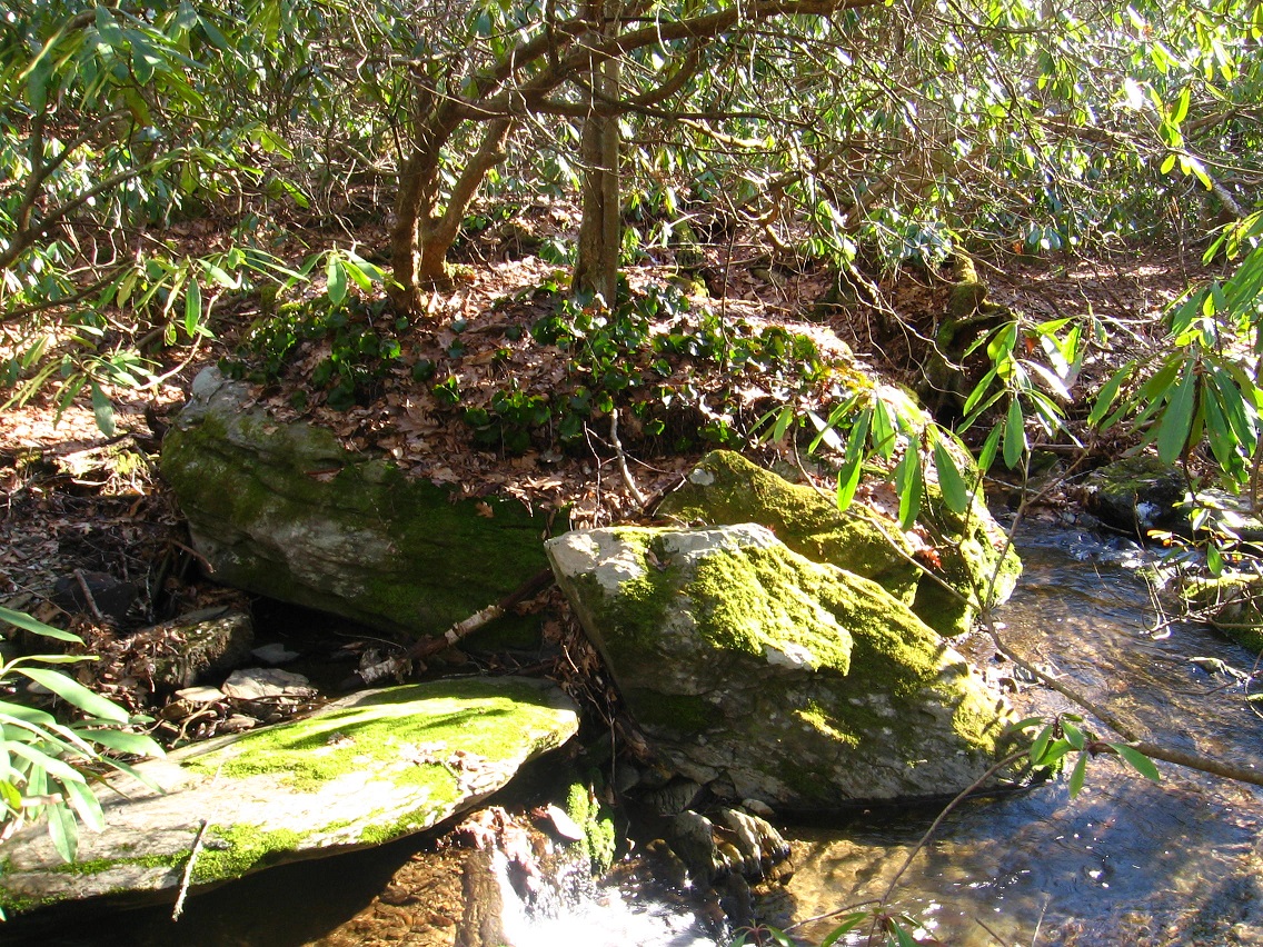
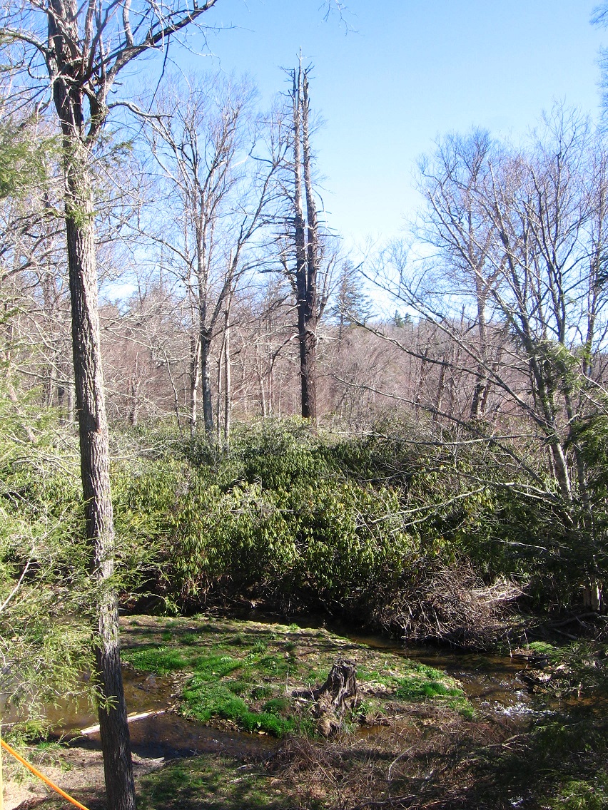
It is fairly clear, I think, that Greenland represents the mountain known as Greene Knob south of Allen Knob. Both of these lie on the western edge of Frank Park, and are of similar elevation. Green Stream runs between the two.

Leaf Erik’son established himself at least temporarily at Vinland in what was later to become WH X-ing. This would be the ancient past. A time blind person could not differentiate past from present and future, however. At any rate a monolith remains, telling us of his presence (presents?) there.

https://bakerbloch.wordpress.com/2014/04/28/whitehead-x-ing-revelations-02/

IMG_0056smaller

“You got it. Leaf was blown into [and through] Whitehead Crossing a number of time.”

bb:

Time?

sophi:

The sadness of sophistication has come to the boy. With a little gasp he sees himself as merely a leaf blown by the wind through the streets of his village.

When the moment of sophistication came to George Willard his mind turned to Helen White, the Winesburg banker’s daughter. Always he had been conscious of the girl growing into womanhood as he grew into manhood.

howlsend01

Leave a comment

Filed under Allen Knob, Frank Park, Whitehead Crossing

Red Head + Greenhead 01

First there was an incident: The Carrots Incident.

This led to Anne buying spurious dye from a road peddler who claimed it would turn her hair a beautiful raven black. No more Red Head.

But the product turned her hair green instead. She temporarily became a Greenhead. Then this was quickly followed by Marilla adopting Anne as a “kindred spirit” to live with her and her brother Matthew at *Green* Gables. She wouldn’t be sent back to the orphanage. The temporary color of the hair was absorbed into the color of the house and transmuted.

Anne Shirley subsequently learned to accept her red hair with this fixed center established, seeing it not so much carrot-like.

I connect all this to Whitehead X-ing because the Green Gable scenes I give a link to above are in Carrcass+6, along with a lot of other pieces of the original Anne of Green Gables tv movie starring Megan Follows. And the audio from the second clip (green hair incident) is also used in the next carrcass beyond this, or Carrcass+5 (remembering that successive positive carrcasses are numbered backwards from 8 to 0). In C+5, Anne Shirley is directly paralleled with the namesake wizard Howl of Howl’s Moving Castle, who was also very distraught over a hair dying incident. *His* hair turned a carrot-like *red*, but then this was quickly replaced by the raven black that Shirley desired so much at the time. Then *everything* turned green and Sophie leaves, saying she’s had enough of this place (Howl’s castle).

http://www.reelz.com/trailer-clips/48978/howls-moving-castle-clip

Leave a comment

Filed under Carrcass Artists, Frank Park, Whitehead Crossing

Red Head Mysteries 02

A snapshot from land above the cascades, where Green Stream flattens out and collects a number of side flows in the process, like the one pictured below. I know — I’ll get some better pictures soon. Just wanted to chronicle the exploration for today’s post.

IMG_0109smallest

I wandered through this more constricted area quite a ways before turning back. Complicated! I can’t wait to map it all out. So this flatter area is above the 2 blocks of cascades we’re talking about. And then there’s flatter land below them, which would border Whitehead Crossing proper to the west and south.

The second section of cascades represents a somewhat steeper descent of Green Stream through Red Head. It also marks the place where Green Stream experiences its steepest elevation change anywhere along its approx. 1 1/2 to 2 mile long route, most likely. The topmost of the cascades is here; again we’re dealing with some very interesting looking rocks…

IMG_0118smallest

… such as pictured here in an earlier blog post…

IMG_0032smaller

And this stone I dubbed South Rock on my initial hike in the area did indeed turn out to be at the bottom of this stretch of cascades before the stream flattens out again. It is the southernmost of the larger rocks, and perhaps makes a nice balance to the rock at the top of the first cascades above it (the “Billrock parallel”), which I might call North Rock, then. But don’t commit me to that.

IMG_0062smallest

Leave a comment

Filed under Allen Knob, Frank Park, Whitehead Crossing

Red Head Mysteries 01

I didn’t go down into Red Head yesterday. My back still isn’t completely healed up, and apparently walking on uneven ground for lengthy spells still irritates it some. Explorations in and around Red Head do *not* involve long stretches of level ground. It’s all uneven to a degree. Which gets to my news today. I *did* find a pretty easy way into Red Head day before yesterday, through relatively open woods. But it’s a descent toward the end, because the stream probably lies 250-300 feet below the top of the ridge I hiked along to get down there. I’m going to give it a name even: Martin Ridge. The side trek peels off from the Maine Trail before it too takes a sharp turn downward in heading toward the direction of Whitehead Crossing proper. And it was also reinforced to me the same day that there really seems to be no easy way at all to get from one to the other. Red Head is effectively blocked from Whitehead X-ing. And that’s good in a way, and how it was “designed” I’m sure, let’s put it. That person or those people constructing and using the WH X-ing teepee, for example, probably can’t get to Red Head, even if they heard me over there walking about.

Interesting grouping of tree trunks encountered while heading down the ridge to Red Head:

IMG_0070smaller

Remember: When Allen and Martin switch places with each other, all will be revealed about Whitehead X-ing, Red Head, and all the rest. But that switcheroo is probably a considerable distance in the future still, perhaps decades and decades.

And I believe my intense focus on Middletown is over for the moment because of the Red Head findings. My attention is fully on Frank and Herman Park presently and the Blue Mtn. region. For now.

Red Head: general areas.

Green Stream is the spine of the area. Two blocks of cascades help define its passage through Red Head. The first block creates an area that reminds me of Billfork in character, with a standout-ish rock and also a side spring, like Billfork has Billrock and Billy Spring. This block really only has 2 well defined cascades if memory serves — at its beginning and end. The first or top one starts around the place where the largest rock of the area is encountered. I still do not have a name for this rock. I’ll give a picture of it again…

IMG_0034smaller

The second cascade, a mossier one (Mossy Falls?), comes right where the side spring empties into Green Stream. Unfortunately I still have not created a blog worthy photo of it; will try again quite soon (today? Sunday?).

Rocks near top of first cascade:

IMG_0082smaller

Interesting rusty piece of metal jutting from the ground there:

IMG_0081smaller

Manmade rock:

IMG_0093smaller

First cascades. Esp. interesting seeming, squarish rock in the middle of the mossier ones here; can you spot it?

IMG_0099smaller

Leave a comment

Filed under Allen Knob, Frank Park, Whitehead Crossing

Whitehead X-ing Notes 02

Study: WIS maps. Red Head may equal the central WIS?

Mall Meadows (famous for its 5 shot lattes) may have also been called Five Points (source: Washington County, FL).

An important concept is that the bees, like Hucka Doobie (or anthropomorphized bees) use to live at Whitehead Crossing before being basically forced to move to Greenhead to escape persecution. Uncle Zoe and Aunt Joe plugged up their main hole, the Mammoth Hole to them, like the entrance to Mammoth Cave. They found another (smaller) hole at Greenhead. Waxy greeted them as they were released to freedom. The bird beats the bug.

So the bees may have been the original inhabitants of Whitehead X-ing. Did their honey attract Pooh, then?

The Bees still met other Whitehead Crossing related species at Mall Meadows.

Direction Rock: one of the WH Xing wonders?

GNIRPS may have been started or maybe moved to WH Xing in the past. GNIRPS is a computer or computer program based upon US maps. Maps about *us*.

Map Rat may be in at least partial charge of GNIRPS (source: MO). If so, Rat (conj. Map) is connected to the mythical Giant Rat of Sumatra. Cousins: Elephant of Celebes (Max Ernst) and Rose Hobart (Joseph Cornell; location=Boreo).

Map Rat is assoc. with Gang of Willard (1 member).

In short, Map Rat is from Real Life Sunklands. Source of that equals MO again, specifically Shannon County.

This is still very important: There is a direct link (portal) between my Little Whitehead in WH X-ing and Little Whitehead Summit on Monhegan Island, ME. And it probably generates all the other Maine related synchs in area, including Norum(bega), Nautilus Island (reached exclusively through Whiteheads), Gray with its lone Southern soldier and also Blue Feather Gallery on Brown Street, and also the reversal of North and South in Oxford County (Mexico-Peru to Norway-Sweden-Denmark), and also Bull Rocks at Dixfield. Maine is much about Whitehead X-ing. Believe it!

—–

White Rock, Whitehead Crossing, has power. Extends this into the White Rocks of TX, pointing out Petty/Pettiway (Petty + Ewa) and also the White Triangle of White Rock – Whitewright – White Rock. This is just beyond w. line of Fannin County, as the White Rock near Petty (and Petty, in turn near “High”) just beyond *east* line of Fannin.

We now also know that Petty is connected to Tom Petty, who is probably referring to being high in the song “Running Down a Dream” featured in Carrcass-10.

In Spring 2013 during another run of Whitehead X-ing related posts, I figured out that Seal Stone sits atop Grey Rock, making “Grey Seal” in toto, like the Elton John song. The spring beside it with no name quickly became No Title Spring (after the song before Grey Seal and after the title song of the album, GYBR: “This Song has no Title”).

The very shallow pool just discovered in Red Head may have been named Big Blue Pool in the past (source: Washington Co, FL again). Much deeper in past. It definitely has a story. You can’t easily get from Red Head to Whitehead X-ing from this direction, as reinforced to me just yesterday (!).

—–

Zebra Station at or near the mouth of Concreek points to Head Trip, which may be coded within a computer there. Black and white, like a Zebra. Zebra, Missouri and nearby Damsel Island is the source, however. It lies on the edge of Korean Channel, which is a important *tile* within Head Trip, perhaps what it was all built around.

This is a way beyond Billfork. This is Head Trip. Solidifes Whitehead X-ing as *the* place to create an art happening in the future, perhaps a cabin even.

Green Turtle also “found” in Spring 2013, along with the Wilcoxson cemeter and the Totem (Land of Blue and Purple).

4 Sticks also known as ZoSo, perhaps degenerated to SoSo. Big Log also named Spring 2013.

Yellow Bricks hidden at Tinsitiy originally come from WH X-ing and it’s “Rocky Trail”?

Imp. Whitehead X-ing related post here to review carefully:

https://bakerbloch.wordpress.com/2013/04/23/whitehead-x-ing-thoughts/

—–

The Emerald name also coined Spring 2013.

Diamond Rock found late spring 2013. On Diamond Beach of Whitehead Brook. (a 4×7 magic diamond? like centers my opus 1 drawing)

http://www.peeron.com/inv/sets/2989-1

Walk the Contemplation Loop this summer when and if possible.

Leave a comment

Filed under Allen Knob, Frank Park, MAPS, Missouri, Whitehead Crossing

Whitehead X-ing Notes 01

Birds beat the bugs at Greenhead, after the bugs (bees) were defeated at Whitehead X-ing (Mammoth Cave hole double — see Falmouth collage 61!). Bird = Waxy symbolically (bird like formation at Greenhead hole). Traditionally the bird and bug are both *Martin*, like the knob (Allen to Martin Knob). Once Allen Knob becomes Martin Knob then all will be revealed. The location of Whitehead X-ing. The Art. All.

For now, Martin remains the primary falls on the Mountain. But in the future: Martin to Allen and Allen to Martin (source: KY, SD, NE, more).

Begin to think of Gene Fade’s production “Fade to Moss” again, a symbolic tribute to Mossman culture and expansion. Mossmen find Korean Channel and Whitehead Crossing location at its top. Silverberg established (Spongeberg related now?). Concreek explored and mystified. It was turned into an Alchemical Treatise.

Gene Fade wanted to use Whitehead X-ing as location for filming. Mossmen established themselves in Red Head. Bees were already over in neighboring Greenhead. All’s that was left to do was develop Whitehead X-ing, where it all went down. Rock (who became center of Fade’s tall tale) crashlanded into Mattland. Spotted Eagle Rock — Crocodile Rock. The whole of Coahoma County, Mississippi was involved (source: Dundee). Elton. Rocket Man. Came over from Sharieland in Herman Park, some say, and they may have been correct. Elton steps up from Mattland through Welcome Matt Rock, right through where the brand new teepee has been half erected. This is the southern edge of 4 Sticks, which represents ’73 and Goodbye Yellow Brick Road (and also Led Zep’s Zoso album from ’73 — and all ’73 albums really). Then Grey Rock and Seal Stone beyond its northern side, after you at least symbolically cross Big Log. This represents establishment beyond Sharieland, and the first 4 songs of Elton’s album GYBR (also: Green, Yellow, Blue, Red — TILE). No Name Spring here too.

I’m still impressed and, really, amazed how Red Head is so successfully blocked off from Whitehead Crossing. The Mossmen must surely have valued their privacy and security. But still they came to Whitehead, coming from the mysterious east and this Red Head no one seemed to be able to locate.

Blue Skies Mr.: An important concept to bridge Red Head and Greenhead energies and create the Whitehead X-ing matrix. Supposedly Rock (= Elton) created Blue Skies Mr. as a God to worship, perhaps modeled upon his own physical creator Sinclair from the Sinking Creek Designated Mystery Area in Virginia.

RGB_illumination

elton
Elton explains love of Blue Skies Mr.

Climactic scene to “Fade to Moss” might have occurred on Grey Seal. Threat of a fall?

Edward Stone or Edward’s Stone becomes a complement to Grey Seal (Grey Rock plus Seal Stone). Edward Stone then becomes Edwardston, and a sity is established, like the Emerald City. Elephant. Sharon Stone. Moss. Meade. Greenberg. Green Turtle (One of 7 Whitehead Crossing Wonders?) points this out, as there was a Green Turtle city next to Edwardston city in Mythos. The Emerald (grass growth) as well.

Wonders (will work on more later):

Diamond Rock
Welcome Matt
Green Turtle
Grey Seal (Grey Rock plus Seal Stone)
White Rock (?)
No Name Rock (?)
Edward Stone (>Edwardston)

Others:

Orange Hill (site of Fal Mouth Moon with its *61* collages). Orange Hill, some say, is the Crossing itself. 61×49. 2989.

Fal Mouth Moon was originally known as Castle Dundee before its conversion into an art gallery. Man named Dundee (with his wife) lived there. Cause of curse?

Fal Mouth Moon is direct bridge between Real Life (Whitehead Crossing) and Second Life (Collagesity). This portal was sealed by X-ians in AD 100 (After Dundee 100). Rock with cross topped Orange Hill, then, as in Falmouth Collage #__. Dingo appeared at top, and Fox below, at bottom of (Orange Hill) cliff, also known as Cliffs of Dundee.

http://www.washingtoncountyhistoricalsociety.org/orangehill.htm

Leave a comment

Filed under Allen Knob, Frank Park, Whitehead Crossing

Red Head related names

2 Greenheads in US, both with an elevation of 144 feet (12 x 12). Synchronicity or chance?

greenhead01

Greenhead, FL, with nearby Red Head. This is only Red Head pp in US. A low summit of this name exists in another Washington County, in Maine.

greenhead02

I think here of Anne of Green Gables and her red hair, which she accidentally turned green just before she was accepted by Marilla to stay at Green Gables.

megan
Anne’s red hair

anne-dyed-hair
Anne’s temporarily green hair — misery!

Obviously when one’s hair turns white with age, you no longer have to worry about your original hair color unless you dye it. Accepting one’s [red] hair equals acceptance of oneself. Accepting one’s white hair equals acceptance of one’s *older* self. We are all figuratively white in the end, if we live long enough.

Whitehead in Da Woods.

Leave a comment

Filed under Allen Knob, Florida, Frank Park, Maryland, Whitehead Crossing

Thoughts

I probably need to give up Collagesity in Minoa in a couple of days, but can I manage it? I just talked to Carrcassonnee, who made a brief reappearance in the town’s temple. She said to remember her for who she is, and also that she would return. She recently had a baby — wonder what happened to it? But I suppose that might just be my keyboards (arriving Tuesday!). So what I need to do is save *all the town’s art*. I’m not going to worry about saving the altered Fal Mouth Moon structure. I’ll just re-create it as needed later on. My Sunklands site is up for renewal in August, and I want to make sure that will continue. I suppose.

Amazing new developments out in the *real* woods. Yesterday I found a whole new section of Whitehead Crossing which, quite peculiarly, seems to be blocked off from the main part. That’s why I hadn’t found it before. But Sunday was different. Now — perhaps even today — I have to figure out an easier way to get into it. I believe this to be the Mossman’s Red Head, mentioned here on this old map (top right)…

https://bakerbloch.wordpress.com/2014/04/30/new-whitehead-x-ing-map/

… but only hypothetically. Another name, then — looking at this map — could be Burnt Head, like on Monhegan Island along with its already employed Whitehead and Little Whitehead. I’m going to leave Blackhead alone, however.

monhe00x

RedDoor2
Now I know what’s behind the Red Door.

Leave a comment

Filed under **VIRTUAL SL, Frank Park, Heterocera, Maine, MAPS, Rubi, Sunklands, Whitehead Crossing

March 29 2015 photos

New territory discovered not once but twice yesterday (Sunday). We start in Boulder — or more precisely on the edge between Boulder and Herman Park — where for the first time I poked around the mouth of TILE Creek as it empties into a fork of the Old River (ironically one of the newest rivers in not only the United States but the world). The mouth is found just off the short driveway down to the Boulder Water Treatment Plant from the main highway. Plant employees have apparently created steps down to the stream juncture; a kind of miniature park. Perhaps they go there to eat and relax at lunch and on breaks.

This is the small gorge that the Old River fork runs through just before encountering TILE Creek. Possibilities exist here for future toy happenings. I was happy to find it. Civilization lies all around this pocket of gorge-ous wilderness. 🙂

IMG_0011smaller

A small but very sandy beach just downstream from the TILE-Old conjunction.

IMG_0019smaller

This hemlock towers over it — obvious ruler. This is yet another spot that could serve as a toy happening.

IMG_0020smallest

A green-ing island at the Mouth of TILE. Green Isle I suppose is as good a name as any.

IMG_0027smaller

Then I decided to hike in neighboring Frank Park this same day and found another new and most likely more important discovery: a whole *’nother section of Whitehead Crossing*, effectively blocked off from the main part. That’s why I didn’t find it until yesterday. I will definitely be heading back to this area sometime during the next handful of days. For now I’ll say that Green Stream, Whitehead X-ing’s largest water flow, cascades through the western edge of the open area. This region has also been called Red Head in the past, and supposedly where Mossman settled in ancient times after finding the Korean Channel through the old Spoon Fork Portal System. But Red Head remained only conjecture until yesterday.

Interesting rocks at the top of one of the several Red Head cascades. I’ll most likely create a map of Red Head sometime this spring, when I gather more information. First off, I have to figure out an *easier way into it* (!).

IMG_0032smaller

This seems to represent a very important rock toward the northern limit of the cascade series. Additional info soon (once more).

IMG_0034smaller

Many interesting features in the cascades region.

IMG_0045smaller

And this is a shallow pool of water found nearby which I also hadn’t known about before. Most likely it will garner a name soon as well. But as hard as I tried, all paths heading toward the main part of Whitehead Crossing evaporated from this direction. I could *see* the main part through the trees and rhododendron — just couldn’t reach it.

IMG_0058smaller

Rotted tree near the pool.

IMG_0061smallest

Another nifty Red Head rock on Green Stream, this one toward the southern end of the blocked off region. South Rock?

IMG_0062smallest

Leave a comment

Filed under Allen Knob, Boulder, Frank Park, Herman Park, Tile Creek, Whitehead Crossing

The Ra.

ehearts

http://anagram-solver.net/earth

harte
hater
heart

I’ve just initially explored what on the below doctored map can be called the “Mercury Ridge” of Sharieland.

https://wordpress.com/post/38932651/7344

cueballeightball04

Herman’s Mansion in Disguise, once more:

munsters

More soon! Sharieland may be a spring hiking focus. I’m almost healed.

1 Comment

Filed under Herman Park, MAPS, Sharieland, Virginia