Category Archives: Illinois

Red Umbrella

I believe the new collage series may be basically finished with the creation of “Triumph of the Toys”, a simpler composition. I’ll continue to interpret the tetraptych that came before this tomorrow. And I have a name for the series: Stones Throw. This comes from what appears to be the only legitimate golf course in Jasper County, about 4 miles west of the county seat of Newton. The appellation is in line with the naming of the other 2 series within the Red Umbrella, which also involve locations near this town (Sam Parr (State Park) and Embarras (River)). And what I really like about the name is its similarity to Stonethwaite, a UK location which dominates the Stones Throw series toward the end (tetraptych and then “Triumph of the Toys”). I might even call it Stonethrow to make the association more obvious, this word beginning with the same 7 letters as Stonethwaite.

Anyway, it’s all bleed’n coming together. The Red Umbrella Gallery is also essentially finished. Will I stay next to the Rubi Forest now all that’s over? The development of Collagesity has gone hand in hand with the evolution of this gallery and its 3 series. At the beginning of June, the virtual village will be one year old, although its existence spans two different locations (Noru and then Minoa/Rubi). I still have a considerable number of prims to play around with on the property. Is there more town myth making in the near future?

The other option I have is to disband the town and take the completed Red Umbrella to a new location, perhaps renting a smaller piece of property at least for a while to save money. But, if so, I’d like to take the larger Falmouth Gallery with me as well at the very least. And I would miss all the rest of Collagesity for sure. But is the potential downsizing worth saving, say, 30 dollars a month? I can see going both ways. Typical. 🙂

At any rate, I believe I’ll get rid of the abridged version of the Red Umbrella in Mysten within the week. I can’t rezz a gallery kiosk there.

Snapshot2031_002
front entrance, The Red Umbrella gallery (rain)

Snapshot2031_004
back entrance (fog)

stonesthrow01
Stone’s Throw Golf Course near Newton, Sam Parr (State Park) & Embarras (River)

Leave a comment

Filed under **VIRTUAL SL, Heterocera, Illinois, MAPS, Rubi

“Confessions of a Rainbowologist”

I’m going to begin thinking about this potential work. It might start in 1977 when I landed a job at the Land of Oz theme park cleaning bathrooms and painting birdhouses and sweeping the yellow brick road. My best friend played the Scarecrow. He introduced me to one of the guys acting as the Cowardly Lion of Oz who was also part of a local G. I. Gurdjieff teaching group. We started attending, and soon learned of the enneagram, claimed to be a universal model. Much later I found what appeared to be a version of it in Dark Side of the Rainbow that “completed” this best known audiovisual synchronicity — filled in the missing central triangle. It might also represent a way I could finally start to understand the symbol’s meaning. Illusion? Perhaps. But what are the chances that the *Cowardly Lion of Oz* would again be directly involved?

edwards

Leave a comment

Filed under Illinois, MAPS

Genes 01

http://www.biography.com/people/groups/famous-named-gene

This post will pertain to Mossman actor Gene Fade, as extended, for example, into Gene Wilder.

Gene “I to y” Wylder — A PRIOR. Home: Trident Streams to the immediate west of Gene Fade Mtn., and in the westernmost region of Frank and Herman Parks as a whole.

Perhaps [even] Gene *Wildest* per description of these creeks here:

https://bakerbloch.wordpress.com/2012/12/30/middle-trident-stream-01/

The streams fan out below this commonality, roughly forming the shape of a downward pointing 3 pronged trident or head of such, as classically associated with the Roman God Neptune. The names Lower Trident, Middle Trident and Upper Trident for these streams, north to south, is made more apt by the fact that tributaries merging into a single stream are often called prongs. This general area is possibly the wildest and most remote part of Frank and Herman Parks as a whole.

Also: Wild Wild[er] W[ild]est.

2914465-the_wild_wild_west_16

PRIORSBURG. link

Parents Boaz and Viola buried (in Graves).

ky-graves-county-kentucky-1905-map

There is evidence that Prior is WIS (Wizard — played by Richard Pryor in The Wiz). Gene Wylder joked about himself being Gene Prior. He saw into Future as Gene Fade, a nodal personality destined to reside in Whitehead X-ing.

It was Gene *Prior* who wove his lifestory at The Weaving Spot.

Must talk of the Loop of Chuck also on Fade’s Mountain or on its south side, where Story Room’s Chuck or Charlie and I fused as fellow yellow composers (Ear) just the other day (as channeled from a probable future event).

Snapshot1151_002

The story of Gene Fade becomes the story of Frank and Herman Parks.

It must have been at Whitehead X-ing:Red Head where Gene Fade discovers his Gene(s) Prior, and the WIS connections. This leads to Tinsity. Excitement.

—–

Boaz indicates superheroes, particularly Superman and Batman via Illinois and Wisconsin. See here:

map

52921463
Metropolis, Illinois

COrichland

gothamwisconsin01
Gotham, Wisconsin

Additionally, Boaz + Viola in Graves County, KY is also near Metropolis, Illinois, indicating a continuation or extension of Story. Death of a Superman. Death of Superman’s[ spouse]. They become PRIOR.

Superman_III_poster

http://en.wikipedia.org/wiki/Superman_III

Webster orders Gorman [Richard Pryor] to use his computer knowledge to create Kryptonite, remembering Lois Lane’s Daily Planet interview with Superman, in which Superman identified it as his only weakness. Gus uses Vulcan to locate Krypton’s debris in outer space.

But in the end the brothers come together to bury the evil supercomputer. It becomes PRIOR too. “y to I”.

supermanpryor03

11REEVE2.2
Gene and Superman in Superman I

There is also a Neptune in Richland County, WI near Boaz and Gotham. Neptune NJ is birthplace to not one but 2 actors who played prominent Batman villians. Can you guess them? Hint:

getting-pianolesson1969
Easy Peasy

Leave a comment

Filed under Illinois, Kentucky, MAPS, Wisconsin

map happenings 03

So we’re back to Clyde and Big Chimney.

Clyde (excerpt):

clyde02

Hucka D.:

You were fishing for an answer and you were pointed toward The Mouse[ again]. Not just A Mouse mind you. *The*…

bb:

… yeah, I know. *The* Mouse. How did R. Booger Hayes then know about The Mouse? And I guess we’ll be entering that queer territory of “Mouse-speak” here, once more.

Hucka D.:

It didn’t, but it will.

bb:

See?

Hucka D.:

Not in that way, but in that way. Half and half.

bb:

Will we ever get any straight answers about this?

Hucka D.:

Big Chimney is a folder. Q109 but R110. Half and half[ again]. Abbaddon… a bad one. Kills us all.

bb:

Sounds like Satan, Hucka D.

Hucka D.:

He is. Or she. He probably. Half and half?

—–

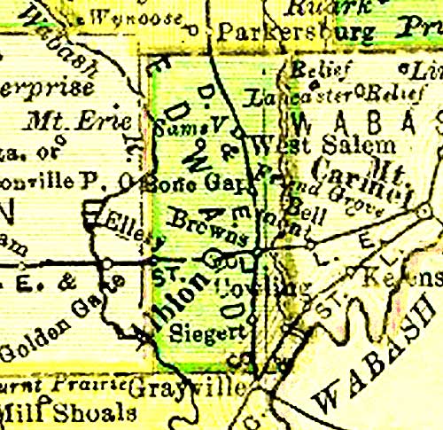
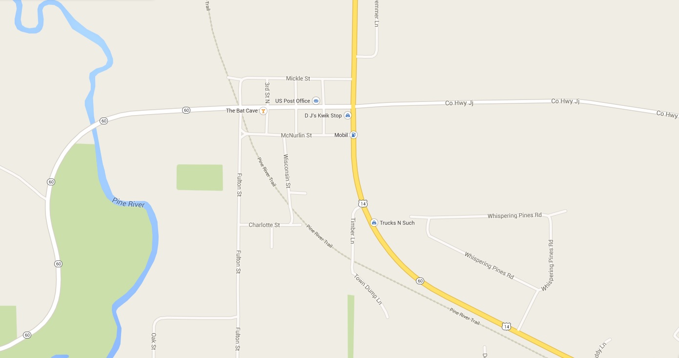
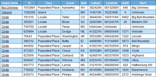
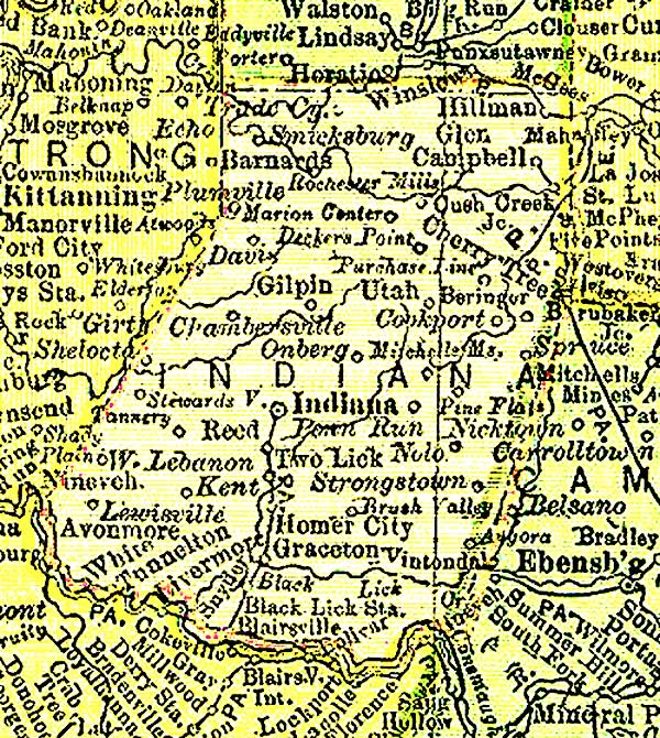
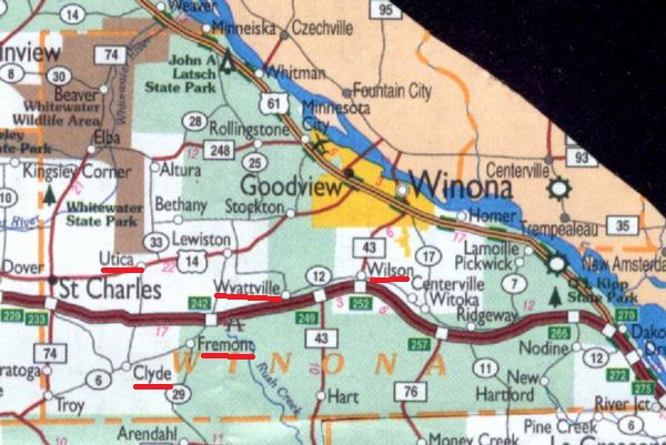
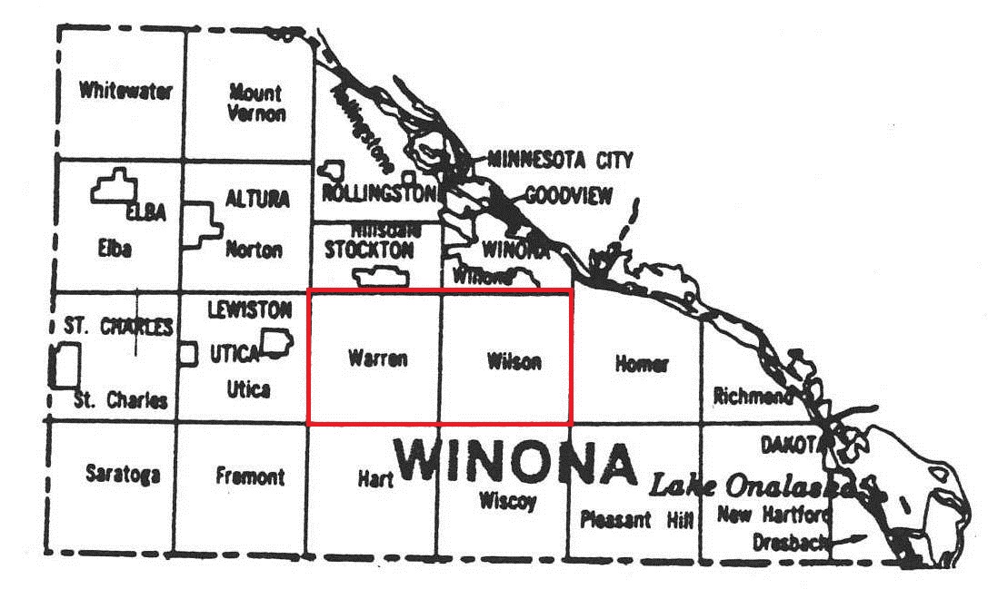
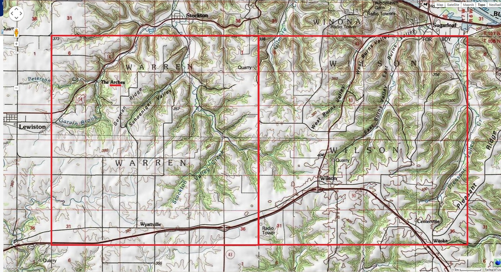
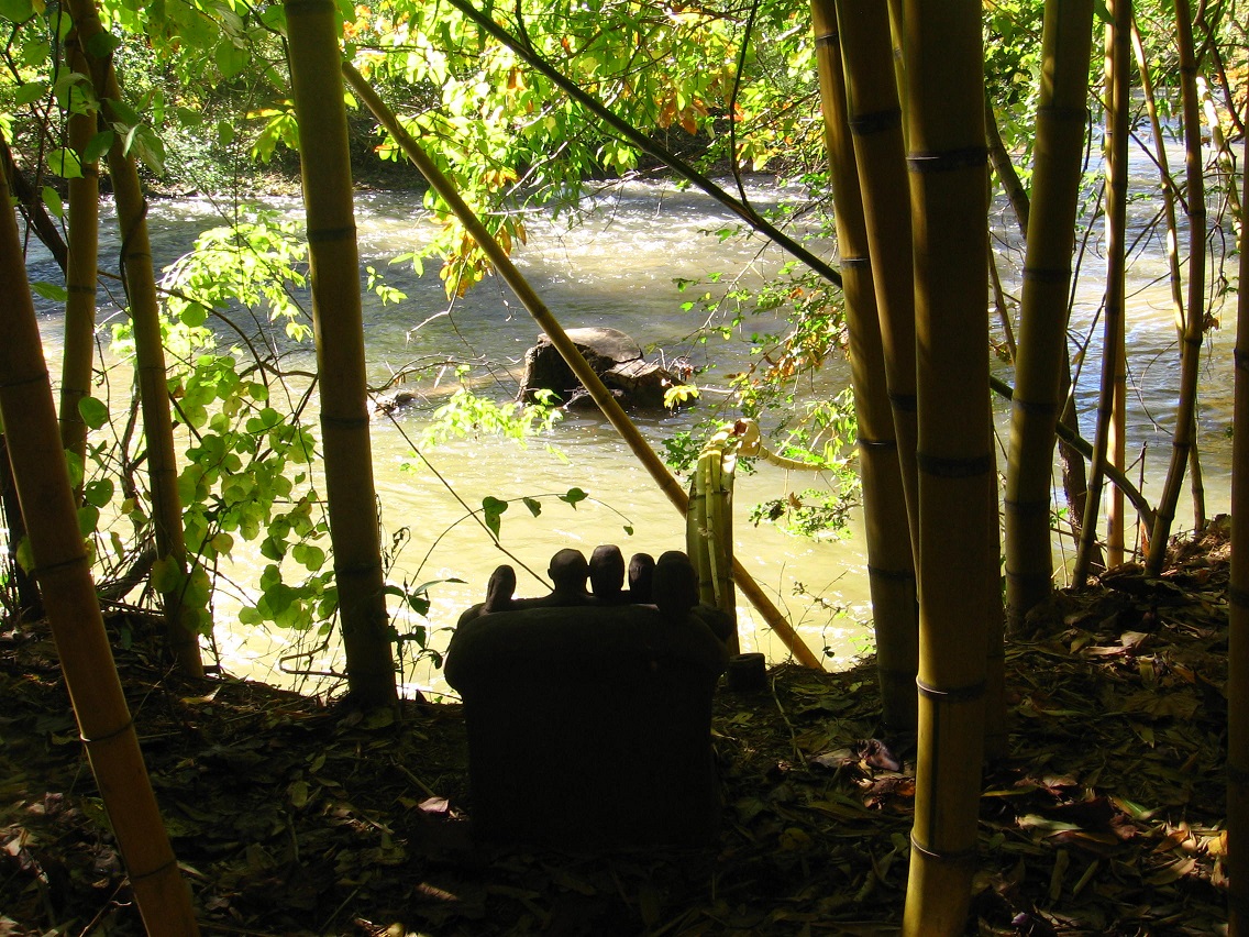
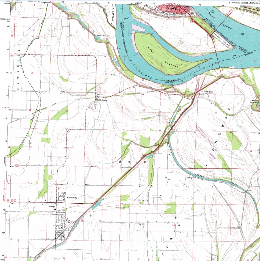
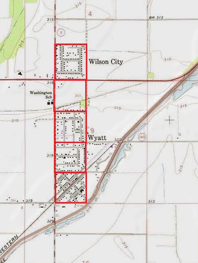
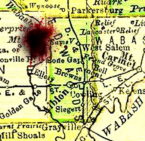
I decided to let Hucka D. rest for later. One curious thing struck me about the entire list of Clyde pop places in our US of A. If you alphabetize by county, Clyde in Pennsylvania is in an Indiana County and immediately below it we have a Clyde in Iowa County from the state of Wisconsin. I looked both up on topo maps — turns out Clyde, Wisconsin is near a Wyoming, which is also in Iowa County. Then in looking up a map of Indiana County in Penn. online, the town name Utah stuck out from among the rest.

That’s a Wyoming (town) in Iowa (county) in Wisconsin (state), and then a Utah in Indiana in Pennsylvania.

Iowa

indiana

I wondered how many towns with the same name as a state existed in a county with the same name as a different state which existed in a state different from either of the other two. So I decided to check… didn’t take too long, about 45 minutes. Let’s even include Washington in the results. Here they are — not many.

This is the first that came up in my search, just starting with Alabama (town) and moving forward in the alphabet. A California exists in a Washington County in Pennsylvania. This is perhaps interesting because the town has come up before in this blog, because of its variant name of Philipsburg [LINK].

california01

So here’s the rest:

kansas01

texaskentucky02

washington02

wyoming02

But if we eliminate anything connected with the name Washington, by far the most common state name on all 3 levels, then we are left with our two original examples and Kansas in a Delaware County in Oklahoma. Oh but by the way, a Carolina and a Wyoming exist in Washington County, Rhode Island, just to be complete about all this.

Kansas-Delaware-Oklahoma doesn’t strick me as odd as Utah-Indiana-Pennsylvania or Wyoming-Iowa-Wisconsin. For one, there’s 6 Delaware counties in the US, as opposed 2 two named Iowa (Wisconsin and Iowa itself) and our 1 Indiana county (Pennsylvania). So let’s say I stumbled upon a unique map oddity through just a single extrapolation of Clyde town names across our country. Does it mean anything? Why these 6 states in 2 triads? Well, let’s take this angle. If I had to choose between the 2 triads in question, I might give the nod to Wyoming-Iowa-Wisconsin as being stranger, since Wyoming, Wisconsin is still a village and Utah, Pennsylvania appears to be extinct as far as I can tell. Also, Clyde is much closer to Wyoming in Wisconsin than Utah in Pennsylvania. So… Iowa and Wyoming have actually been coupled together with yet another state in this blog before to create a joke character called Ohiowa Oming. That’s 3 states again, with Ohio subbing for Wisconsin then, as it were. As it is.

Speaking of the Sam Parr State College enrolled students for its initial session, Hucka D. follows the introduction of Redd Foxx with this:

https://bakerbloch.wordpress.com/2014/09/16/19298/

bb:

Who else has enrolled? I guess we should end this surrealism soon.

Hucka D.:

Dumbgo the Insignificant. He’s probably the worst of the bunch. Patty Pepper Mint herself has enrolled for a jewelry class.

bb:

I believe that one got cancelled.

Hucka D.:

Oh right. A shame. Story Room themselves will teach the class called “Composing with the colors red, yellow, blue”. That should be exciting.

bb:

Kind of a Piet Mondrian effect, then.

Hucka D.:

Pietmond?

bb:

Umm…

Hucka D.:

Who else? The B. R. Cyrus twins Idaho Oker and Ohiowa Oming. Oh, and Fredrika Mercurious, the famous dump truck driver. And Pletiosaurus Rex. I believe that might be it.

bb:

Thank you, Hucka D. Good night, and we’ll get to those collage interpretations soon.

Ohiowa Oming and her sister Idaho Oker (obvious play) as the twins of B. R. Cyrus, who is probably the same as Billy Ray Cyrus or, more probably, a variant BRC. Surely you the reader or readers have heard of Hannah Montana and Miley Cyrus by now. Of course you have unless you’ve been living in a cave. I only live in a cave during a complete loony eclipse, but we won’t go into that. B.R. was or is the coach of the Chilbo high school football team. Sad I’ve just left that virtual area, but now I have the Rubi Woods again (yea!). I guess I’ll have to wait for Hucka D. to wake up again around dusk before getting more answers. See you then!

1 Comment

Filed under Illinois, MAPS, Ohio, Pennsylvania, Wisconsin

up with maps! 04

https://bakerbloch.wordpress.com/2014/11/23/up-with-maps-02/

Why did he [Hayes or Hays] choose to be identified with Fremont in Sandusky County, with its second town as Clyde?

winonacounty02

winonatownships02

wintwp02

ww01

https://bakerbloch.wordpress.com/2014/10/19/ashville-02/

Warren & his owls look out on a stump in Wilson (Wilson Stump). He knows this is where he comes from. He always remembers his origin because it is always within his sight. There is a big drop in front of him, separating carved entity from river. He lies at the end of a 15 (natural) step passage. People marche right by him all the time.

wyattville02

winona1898

WyattEarp-500

thearches01

IMG_3373lg

The Arches, MN

DME 6090 and two other SD40-2s drag an empty moonshine train up Stockton Hill through an area known as “The Arches.” Clearly you can see why it has that name. The future civil engineer in me loves finding cool bridges like this one while out railfanning.

When we saw this train sitting in Minnesota City waiting for a warrant, there was no doubt a chase was in order up Stockton Hill, something we’d never had the chance to do before. But since we’d never done it before, we also didn’t have a great idea of where all the good photo spots were – just that one could follow the tracks for the most part on adjacent road. So when we saw a nice girder bridge just to the east of this bridge we set up there and were quite pleased with the shot. Then we continued only a few thousand feet down the road and found this slick double stone arch bridge. The keystone on the left arch has a build date of 1882. This was a fun chase on a Sunday morning for two railfans from Central Wisconsin. Sometimes the best chases are those where you don’t really know the territory and end up stumbling onto the best of shots by accident.

More photos from this chase and other photos shot on the BNSF and CP on the same day can be found here:

s126.photobucket.com/albums/p89/WSOR_3807/winona1-12/

https://bakerbloch.wordpress.com/2014/10/19/ashville-03/

Dead Center Hill (also see upper right corner of above photo): This is where it all went down. Warren also knew of the place; no lie this time. Warren again separated from Wilson and climbed this hill just to the south of the river, leaving a piece of kane (Old Kane) as a marker.


Arch Rock greeted “Warren Again Separated From Wilson” at Dead Center Hill

http://en.wikipedia.org/wiki/Wyatt_Earp

Wyatt, born on March 19, 1848, to Nicholas Porter Earp and his second wife, Virginia Ann Cooksey, was named after his father’s commanding officer in the Mexican-American War, Captain Wyatt Berry Stapp, of the 2nd Company Illinois Mounted Volunteers. Some evidence supports Wyatt Earp’s birthplace as 406 South 3rd Street in Monmouth, Illinois, though the street address is disputed by some.[who?] Monmouth is in Warren County in western Illinois.[5]

youngest brother:

http://en.wikipedia.org/wiki/Warren_Earp

wyatt03

http://en.wikipedia.org/wiki/Wyatt,_Missouri

It is the eastern most city west of the Mississippi river.

wilsoncitywyatt01
twin towns Wilson City and Wyatt in Mississippi County, Missouri on Wyatt topo map with Cairo, Illinois at top

wilsoncitywyatt02

Leave a comment

Filed under Illinois, MAPS, Middletown, Minnesota, Missouri, Pennsylvania

map stuff more 01

carroll3b

Daniel conj. Day in Maryland obviously refers to Daniel Day-Lewis, but the Lewis most referenced may be this one. We don’t know.

ryanhand

tumblr_lprg28lBI11qgnxxy

Lewis from the Drew Carey Show. Coded in Arkansas. Drew County (Drew, Lewis, *Line* — maybe Lineboro MD is associable here).

drewline01

Drew Carey is a famous registered Hollywood Republican.

http://www.buzzfeed.com/mjs538/40-celebrities-who-are-republicans

republicantopo01
NC Republican map

10154193_10203469538288124_5461910389351713198_n
Daniel Day in the middle now.

edwards02
There will be Blood I suppose.

images
Bertie County again.

http://www.newsobserver.com/2012/05/01/2041723/north-carolina-and-british-researchers.html

Next up: Atlanta?

atlanta01

(to be continued)

Leave a comment

November 16, 2014 · 7:35 am

Thoughts

Ashville in 7-10 years. Have plenty of time to prepare. I can’t really stop thinking about it. A new and entirely different thought flow is occurring, just above my head now. If I could raise up a bit more I’d be in its midst. I would see the correct relation between Blue Mtn. and Ashville, and also Abington, Aveberry, and Mythopolis.

The Bill:

We are ready now.

bb:

Oh. Hello Bill.

The Bill:

You can call us “The Bill”, please.

bb:

Are you from Ashville?

The Bill:

Yes. We are from Bill Creek. We are threatened. That’s why we reached out across time, space to snag you.

bb:

Snag, eh?

The Bill:

Yes.

The Bill:

What is your relationship with Hucka D.?

The Bill:

We are his cousins.

bb:

Hmmm. This Frank and Herman Einstein blog will probably be wrapping up in about 2 to 2 1/2 years, making it about the same length as the Baker Blinker Blog preceding it. Then I’ll probably have a new blog until I retire. Then something new will come along to replace that, in turn.

—–

The Bill:

We are here.

bb:

Thank you. (pause) Sorry again. The Bill?

The Bill:

Yes?

bb:

*Are* you Firesign Theatre?

The Bill:

(pause) No, we are The Bill. The humor chip, as you’ve guessed, has been removed so that we can speak to you more logically about pressing or more important matters.

bb:

I need to declassify the next sync.

The Bill:

Yes. Most definitely. But be careful.

bb:

Do it on the blog?

The Bill:

Yes. Realize that the revelation about Illinois is created by us from the future. Spankey points to Kane. One spanks, and then one canes. Both are punishments, but of different extremes. The copyright has expired on Old Kane so we can make a new Kane. Bottom Fiedler Films put it out, yes. The Kanes in the accompanying movie are also called bottom feeders in the same [tile]. The audio and video become one, then. Young lookalikes named Kane… that’s the bottom feeders of the film, that’s the Bottom Fielder film. And “fiedler” is coded into the same location.

bb:

Let me check something. Thank you very much for this information.

—–

bb:

That place in Illinois we’re talking about is a special spot. The presence of Principia College attests to this.

The Bill:

That was set up for us. As you’re also guessing, it is an art piece, a collage[ of sorts as well].

bb:

K is the 11th letter of the alphabet. J is the 10th, and we have Jersey County with its Jerseyville seat just below[ Greene County]. This relates to the Billfork Core Diagram.

The Bill:

We call that something else. But: yes.

—–

http://www.firezine.net/currant/fredrvw.htm

http://www.nuvo.net/indianapolis/northfork/Content?oid=1228125#.VDuWvBbwHfM

jersey3

Irwin in Harlan County, Iowa. I-G-A; K-M-E

Northfork-Kyle, WV

Norfolk, AR? (near Norfolk Dam)

Leave a comment

Filed under Carrcass+08, Illinois, MAPS

SPSP 33 Line 02

Prime line: 1.32 miles long. The line traverses Sam Parr Lake near its longest stretch of water, at an angle of approx. 338 degrees. The line grazes a quite suspicious number of peninsulas along the way, as I’ve marked on the map. Position 132 is at the upper end of the lake, 1.32 miles away from point 000. This can be read as 4 x 33 for our purposes. Position 33 is 0.33 miles up from position 000 on this line, or 1/4th the way up its length. This happens to mark the only boat found floating freely in the lake in this GoogleEarth map rendering from 2013, that is, away from any dock. Position 25 (0.25 miles from 000) just below marks the end of a pier where another, very similar looking boat is docked. The boat, just to the west of the 33 Line, is also 0.25 miles from position 000. It is the only boat besides the one at 033 not docked at the park’s marina, as far as I can tell. If the end of the SPSP 33 Line is determined to be at position 125 instead of 132, then point 025 is 1/5th the way up this slightly shorted version.

spsp13

How the boat positions along the SPSP 33 Line appear to relate to musical harmonics:

http://en.wikipedia.org/wiki/Harmonic_series_%28music%29

harmonics02

spsp14

Boat 33 (at 0.33 miles) and Boat 25 (at 0.25 miles) define the 2 lake harmonics of 133 (1.33) and 125 (1.25) respectively. Boat 33 is situated at the 1/4th point of the former, and Boat 25 at the 1/5th point of the latter. Maybe they are the same type of boat, even. Maybe they are the *same* boat (:o) at slightly different points in space and time.

spsp15

spsp16

harmonics02larger

1 Comment

Filed under ***collages 2d, Illinois, MAPS

SPSP 33 Line 01

The line originally began at Illinois Highway 33 passing just east of Newton in Jasper County. Although the angle and position of the line never changed, the beginning was slightly later moved up to where it crosses the lowest point of Sam Parr Lake.

samparragain01

http://mysteriousuniverse.org/2012/10/number-33-secret-societies-ufos-death-destruction-disneyland/

samparragain09

The shoreline and attached features to the west take on the appearance of Grandpa Simpson, and I believe this could be reference to his history discussion in the episode Lemon of Troy about the rivalry between Springfield (where The Simpsons live) and neighboring Shelbyville. I quote a wikipedia article on this episode below.

Lemon_of_Troy_28

http://en.wikipedia.org/wiki/Lemon_of_Troy

When Marge catches Bart vandalizing a town sidewalk by writing his name in wet cement, she lectures him on the importance of town pride. Afterwards, Bart realizes how wonderful it is living in Springfield. Consequently, however, Bart also becomes upset with anti-Springfield sentiments coming from the neighboring town of Shelbyville. Grampa explains that this rivalry can be traced back to the establishment of the two towns. This occurred when the founders Jebediah Springfield and Shelbyville Manhattan discovered they had irreconcilable differences regarding their visions for a perfect town, Springfield favoring promotion of chastity and Shelbyville advocating incestuous marriages between cousins.

According to Carrcassonnee’s considerable and unique body of wisdom, the rivalry is directly attached to that of Islam vs. Christianity, or, more specifically, the debate between Abraham’s sons Isaac and Ishmael, as illustrated in the below video from a West Wing episode of the same title.

It’s about Springfield (Grandpa, “an old man talking”), making peace with Shelbyville. They have common roots. They shake hands across the lake.

Reversed, the face across the lake gives the appearance of having a chicken-like beak, and there’s even an attached chicken claw dangling to its side. This *might* be connected to short lived Aqua Teen character Chicken Bittle, an original group leader, but still uncertain of that. This is not as obvious.

samparragain09b

Chicken_Bittle char_66990

More on the SPSP 33 Line in a follow-up post.

—–

I am Karoz Blogger and I approve this post.

1 Comment

Filed under ***collages 2d, Illinois, MAPS

Updates:

I get in trouble if I don’t update this blog on a fairly regular basis so here goes…

Karoz (read: me) is still investigating the shoreline of Sam Parr Reservoir for faces. He’s determined that there are so many as to be useless, so far, in an esoteric interpretation. Of more interest to him (me, again) are 2 nearby formations. One is called the Falmouth Rabbit. Here’s some pictures.

falmouthbunny01

falmouthbunny02

In the second picture, the actual hamlet of Falmouth can be seen in its northwest corner. That’s the aforementioned Brush Creek connecting the Falmouth Rabbit with Falmouth hamlet through a sliver of green. Sam Parr State Park and its dominating lake would lie a mile or two to the southwest here. Brush Creek is perhaps the major stream dammed to create this lake.

A logical interpretation: the Falmouth Rabbit lies between the two collage series of Falmouth (northwest) and the new one called Sam Parr (southwest). The Rabbit is a guiding spirit, perhaps, for Sam Parr State College and the whole of Collagesity. Didn’t Hucka D. recently compare himself to a rabbit?

I actually went into streetview to look around 2 of the four sides of the rabbit formation. Didn’t spot anything unusual, unlike, say, my 2013 visit to Sunfish, Kentucky.

Can we, then, get additional clues from this Rabbit? I’ll perhaps come back to that thought.

The second formation is here…

dragonandboy

I call it Dragon & Boy, or Dragon Meets Boy. I see the boy within the brown field formation as cartoon-like and smiling. The dragon head it smiles at is expressionless. The eye of the dragon is formed by a grayer colored tree of the forest. The tail of the dragon extends northward along the lakeshore. Since the boy is smiling, I interpret this (and Karoz agrees with me) that this is a friendly meeting, and cooperation of some kind is taking place. The boy probably represents humanity, enclosed in a bubble world. The dragon is something alien, in contrast, and much larger. We are limited in scope on this small island called Earth. Those on the outside are seeking to help. They are very close.

Dragon Meets Boy exists in the eastern part of Sam Parr State Park. The lake the dragon’s tail extends along is its central, namesake reservoir.

Karoz is comparing Sam Parr Lake itself to a rabbit and its elongated ears, or, perhaps better, a jackelope. Compare this (Sam Parr Lake outline)…

samparrlake

… with this image found on a blog called ShellHawk’s Nest.

The Most Interesting Jackalope in the World-1smaller

Looks like a pretty good match to me. It’s a happy, cigar smoking, beer drinking creature to behold here of recreational orientation indeed. Reminds me of the main character Fitz of 12 Oz Mouse.

Mouse

http://en.wikipedia.org/wiki/Jackalope

snapshot1011_003
Back in 2010, Karoz discovers another rabbit head shaped like a body of water.

snapshot1011_001

ydisland

—–

“The jackrabbit has been separated from the antelope again. It is your duty to put the two back together. Similarly you must coordinate the new Sam Parr collages with the earlier Falmouth ones. Can you do this? I think you can… with my help.”

karoz02

Leave a comment

Filed under **VIRTUAL SL, Illinois, MAPS, Nautilus, Yd Island