Category Archives: MAPS

Hucka D…

… we thinks both these Louisiana salt dome islands represent planets or maybe moons. The presence of 1 of 2 US Eraths pointed the twin islands out. Avery Island is source of tabasco sauce, mentioned once in Baker Blinker Blog (LINK). Some tabasco peppers are grown on the island. Lt. Pepper sprays pepper spray at the old center of VWX Town. Remember we called him the center? I think this is connected. Salt and pepper are ivory and ebony twins, but this is a different type of pepper. Curious, though… meaningful, perhaps. The twin islands may be similar twins (circles, to the naked eye) Earth and Venus. Pepper spray and tabasco pepper are both hot, like Venus is hot. We thinks Mercury could be Jefferson Island in this same configuration and that Mars is Cote Blanch Island. I will show a map now.

erath03

‘Nother map of twinned Avery and Weeks Island. All 4 islands are salt domes.

v3_slide0006_image002

Attached document:

http://lagic.lsu.edu/SatelliteTour/AveryWeeks/description_files/v3_slide0007.htm

It could be that because the r and a of Erath are reversed from Earth, that Avery Island and Weeks Island are similarly reversed, the more famous Avery being Earth and Weeks being Venus. Let’s look at Neutral Milk Hotel’s [On] Avery Island album.

Hucka D.:

Stop.

—–

2-1-astrophysici

Related 4/18/13 article:

http://phys.org/news/2013-04-astrophysicists-five-planet-earth-like-exoplanet.html

Leave a comment

Filed under Louisiana, MAPS

Lilly 01

lilly01

Laurel_&_Hardy

220px-Daylily_'Hush_Little_Baby'

lilly03

Lilly, PA on Little Conemaugh River.

lilly04

Lilly, PA; Munster, PA

220px-Fred_Gwynne_Yvonne_DeCarlo_The_Munsters_1964

Lily Munster

Leave a comment

Filed under Kentucky, MAPS, Pennsylvania

Herman…

… gives way to Trumann.

hermanar02

Leave a comment

Filed under Arkansas, Herman Park, MAPS, Sharieland

A brief…

… chat with Hucka D. concerning Frank and Herman Parks, VWX Town, carrcasses, and other stuff.

Hucka D.:

Ooops. Time’s up.

bb:

Funny.

Hucka D.:

No: real.

bb:

Then no comments today about any of those important blog subjects?

Hucka D.:

You have come from several directions to the rim of Frank/Herman responsibilities.

bb:

Responsibilities?

Hucka D.:

Just go with it[ for now].

bb:

What are these?

Hucka D.:

The latest is Philo, formerly Myst or Mysten[ Myst plural as I understand].

48431605

bb:

Is that it?

mysten02

http://www.panoramio.com/photo/48431605

Hucka D.:

Yes!

bb:

How?

mysten02b

mysten02c

https://bakerbloch.wordpress.com/2013/10/20/sharieland-once-more-05/

2 Comments

Filed under Herman Park, MAPS, Sharieland

Possible Palmistry Connections…

Cheiro

http://en.wikipedia.org/wiki/Cheiro

Cheiro: Palmistry for All at Project Gutenberg

http://www.gutenberg.org/files/20480/20480-h/20480-h.htm

INSERT: Picture of my hand I accidentally poked at work with a pencil on the Life Line, a day after being poked several times in the same hand by thorns while above the Head Line itself in Herman Park. I noted the connection between the multiple pokings at the time, but didn’t realize until just now, in looking down at my hand, that the last poke occurred precisely on the Life Line. The other pokes from the day before came on the thumb of the other hand (right).

I’m wondering if this poked point on the Life Line represents The Present, or a specific point in Herman Park, perhaps the position of Shark Rock or what I now may call *Poke Rock*, which has an actual hole going all the way through it.

Also confusing to me now is that, traditionally, palmistry’s *Head Line* lies below the Heart Line apparently, contrary to what some Internet sites say. So, top to bottom: Heart Line, Head Line, and then Life Line as the 3 major lines of the hand.

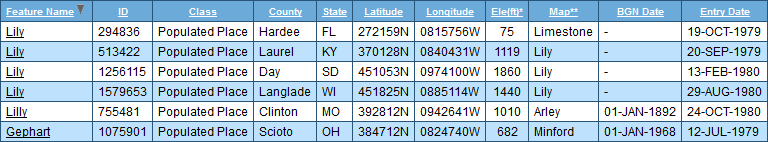
I also wanted to re-examine the Hand map of Baxter County Arkansas talked about before in relation to Sharieland (May post).

Here’s the original source:

http://ozarkshistory.blogspot.com/2010_12_01_archive.html

images
Eye in Hand.

—–

Hucka D.:

Closest to Herman[‘s Mansion]. Dewey defeats Truman. Dewey is Herman. Head Line includes. Um. 2 Hermans on either end. Trumann near Herman Arkansas.

—–

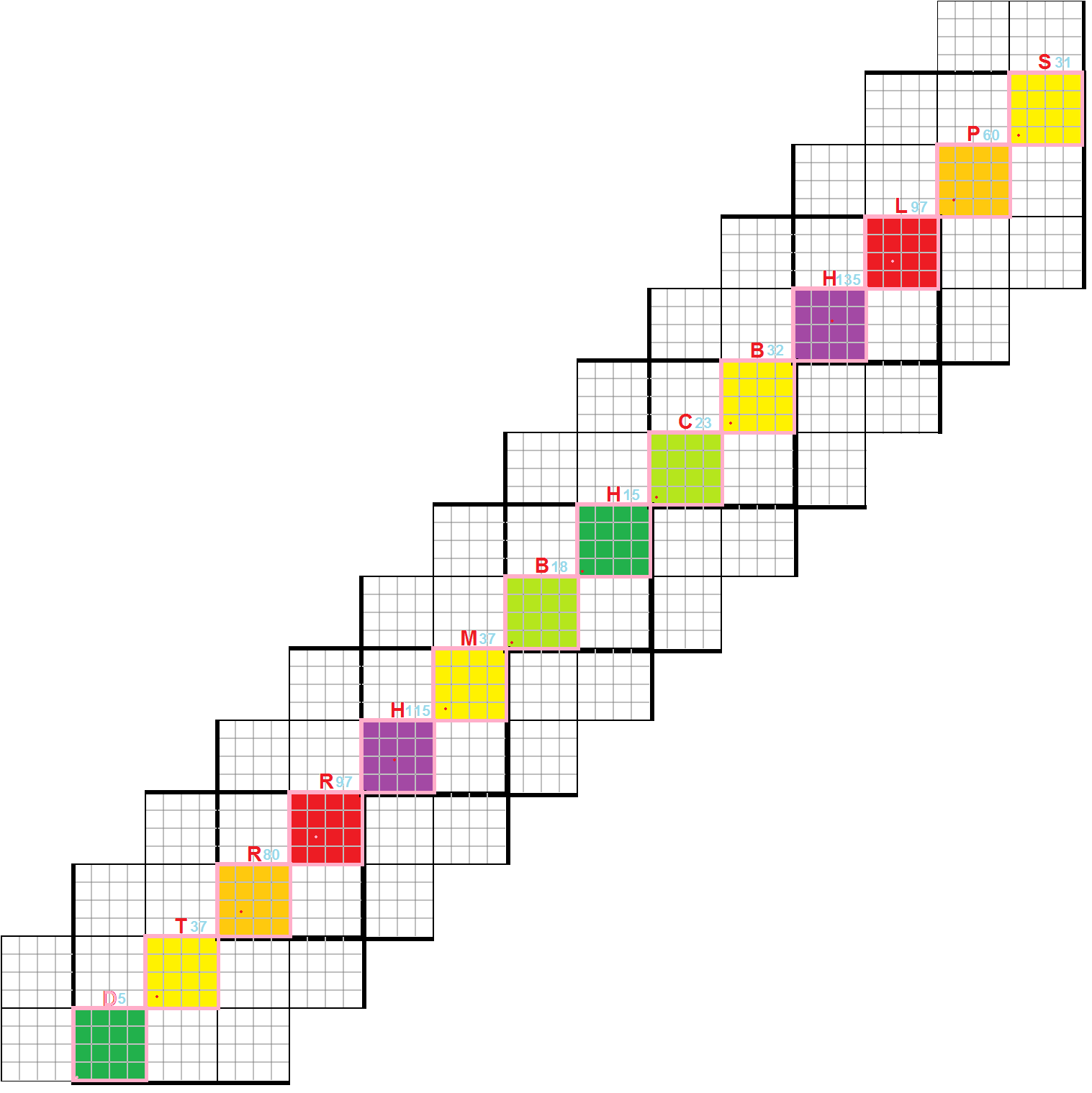
Interesting: “H E A D” and “lines” (grid overlay).

http://www.datasync.com/~rsf1/sfran.htm

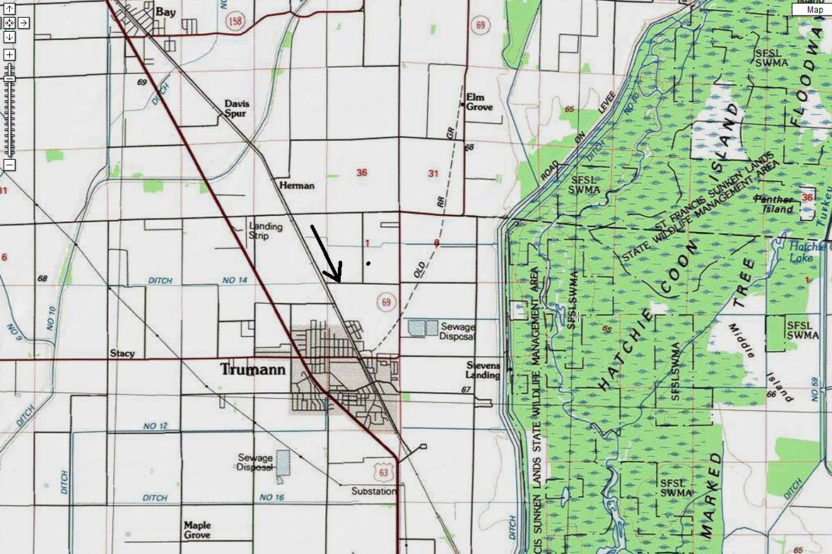
Position of Trumann, Arkansas related to this grid. It lies basically in the exact center on the western edge.

sunklands01

Translation: these grid lines are all *head lines*, like the famous Chicago Tribune’s “Dewey Wins”. This is also the location of the St. Francis *Sunk Lands*.

new-madrid-quake

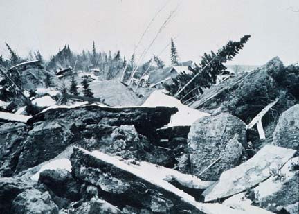
New Madrid Earthquakes as Seen Through Dark Glasses

In the known history of the world, no other earthquakes have lasted so long or produced so much evidence of damage as the New Madrid earthquakes. Three of the earthquakes are on the list of America’s top earthquakes: the first one on December 16, 1811, a magnitude of 8.1 on the Richter scale; the second on January 23, 1812, at 7.8; and the third on February 7, 1812, at as much as 8.8 magnitude.

stock-illustration-13384638-cartoon-pencil

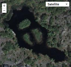
Detail from above map, zooming in. Notice that two names within the St. Francis Sunk Lands involve the two objects that poked my hand several days ago: Thorn [School] and Lead [Fork], situated within 1 mile of each other. These resonate with the thorny bushes that stung my thumb twice, and the lead in the pencil that poked my palm. Notice also there are *2 separate* Lead Forks on this map, not far apart, as if to reinforce this resonance. Am I stretching it? I don’t think so — just being a completist.

trumann03

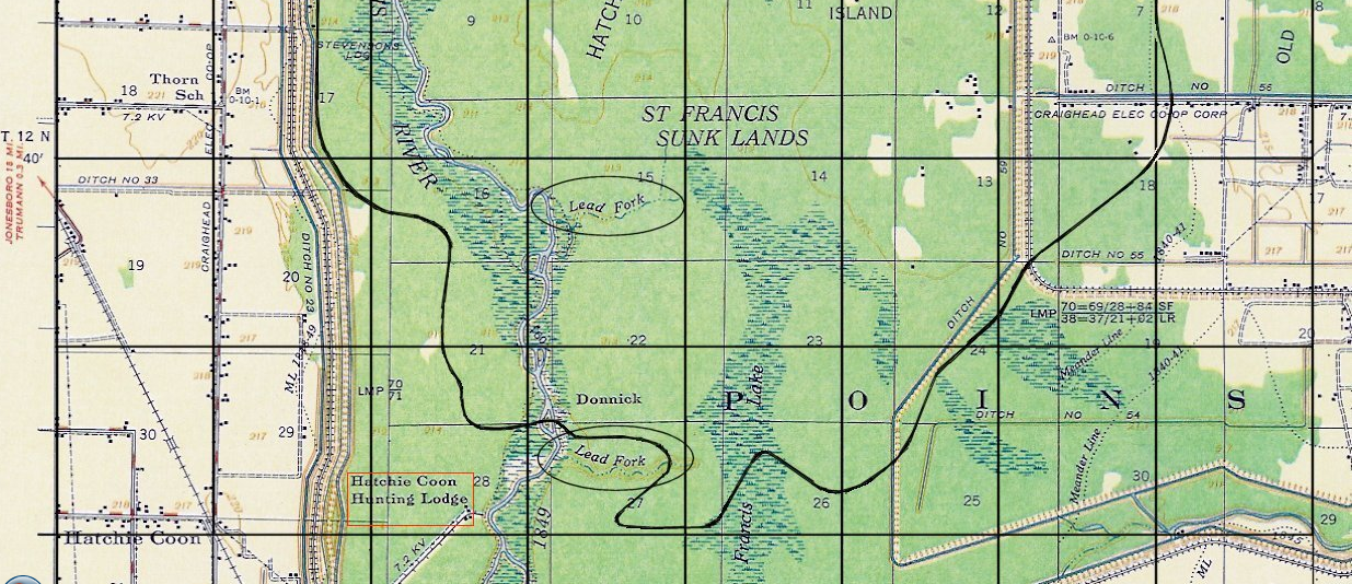
Robert Fritzius, the author of the attached article, noticed the repeated Lead Forks as well, along with some other name oddities within his pinpointing grid. I’ll quote them here, which includes queer info on Panther Island:

The clear cut area near the north end of Hatchie Coon Island was apparently a Homestead Settlement back in 1908. It is accessible from the east via Craighead County Road 82, which is also known as Hatchie Coon Road. [Added 06 Jan 2006.]

About a mile east of the homestead settlement just mentioned, is an area known as Panther Island. This area is enclosed inside an oval on the topo map. Shawnee Chief Tecumseh is credited with prophesying that a continent shaking catastrophe would occur on December 16th 1811. The name Tecumseh means Panther in the sky. Anybody having knowledge of how Panther Island came to have that name please contact the author. (Does Indian history in any way connect Chief Tecumseh with Lake St. Francis?) [Added 28 Feb 2006.]

He continues…

At the bottom of the section of the USGS topo map, shown just above, there is a ditch located along the inside edge of the eastern levee which borders the St. Francis sunk lands. The ditch is labled “Iron Mines Creek.” (This name is enclosed in a elongated vertical ellipse.) Anybody having knowledge as to whether there ever were iron mines in the St. Francis Lake area, and if so, where they were, please contact the page author. Also, on the St. Francis river, itself, near the former southern boundary of St. Francis Lake, are two annotations, “Lead Fork.” (These are enclosed in the shorter horizonatal ellipses.) If anybody knows what the meaning of these notations are, especially if the words “Lead” pertain to the metallic element bearing the same name, please contact page author. [See correspondent’s comments below.]
[Added 26 Feb 2006.]

According to Scott May, a member of the Hatchie Coon Hunting and Fishing Club, Inc., the 1849 meander line (shown on the 1956 topo map above) is a misnomer, because when the surveyors came in the winter of 1849, the water was too deep in the area near Hatchie Coon. This fact is reflected on the surveyor’s notes available in the State Land Office in Little Rock, AR. [Added 08 Aug 2006.]

According to May, the southern “lead fork” is locally known as “Stud Horse Run,” and the fact that the same name appears in two different locations may be a mapping error. He says (with respect to the word lead, as in lead forks) “It is definitely lead as in the metal. I have never heard it pronounced as in to “lead” the horse to water.” [Added 08 Aug 2006.]

The hunting and fishing club, mentioned above, is located on the west side of the St. Francis river, southwest of the lower “lead fork.” On the 1956 topo map, it is located inside the red rectangle. [Added 09 Aug 2006.]

If there were any lead or iron mines, however temporary, in the Hatchie Coon/Saint Francis Lake area, then there may be old photographs, news clippings, or other narrative materials relating to them. These could be tucked away in albums or stored in other keepsake stashes. Any readers who can find any materials of this nature, which provide dates, names, locations, etc., of the mines, is heartily encouraged to contact the author. They can be incorporated on this webpage. [Added 08 Aug 2006.]

More info about an attached theory concerning a comet that passed by Earth at the same time the New Madrid earthquakes occurred by Fritzius:

http://www.datasync.com/~rsf1/1811.htm

He and others speculate the two events could be connected, and that the St. Francis Sunk Lands is the result of a meteor impact that caused the earthquakes (!). And of course, coming from my direction again, there’s the whole tie-in with Second Life’s Sunklands, but that’s too much info to cram into this post.

3 Comments

Filed under Arkansas, Herman Park, MAPS, Sharieland

Bedrock Mystery

Bedrock

bedrock crackhttp://minecraft.gamepedia.com/Bedrock

http://bedrockorbust.blogspot.com/2010_09_01_archive.html

Pictured to the left is a spot that kept my interest high. This bedrock crack payed me 55 chunky pieces of gold in one pan within the area circled. That’s only about a foot in length. I chased the crack further toward mid-stream but it didn’t pay as well as it did within the circled area.

Bedrock_skyline_season1

Leave a comment

Filed under Green Oz Creek, Herman Park, MAPS, Tennessee, Wealthy Mountain

Repetition

the_shining0696-640x360

Been reading this most excellent and fascinating site about Kubrick’s The Shining. Recommended for anyone interested in the director.

http://www.collativelearning.com/the%20shining.html

Also watched most of the “Room 237” documentary yesterday and came away much less impressed. I don’t think it will be used in a, ahem, carrcass.

http://en.wikipedia.org/wiki/Room_237

Next up might be this:

http://www.jeffreyscottbernstein.com/kubrick/theshining.html

Or this…

http://jonnys53.blogspot.com/2007/06/what-you-may-or-may-not-have-seen.html

As for The Shining movie itself: definitely in a carrcass. 🙂

Bakerswork (var: Crow), Tennessee.
Dull, Tennessee.
MAP SOON.

2 Comments

October 1, 2013 · 5:04 pm

Texas

Last night I wrote about Texas synchronicities related to VWX Town and its new Northside. I also posted the link to this blog entry on the Synchronicity Phenomena, since it relates to former board guru/leader Don Boulet. Tonight the wife and I watched an episode of The Big Bang Theory where main character Sheldon (another guru/leader) runs home to his mama in Texas after being embarrassed by friends and colleagues at the university he works. A flag of Texas covers one of the atomic particles in the segue to the Texan location in the episode, which I pointed out to the wife, who didn’t originally see it.* Now, just minutes ago, was looking up more info on Don and discovered this online work, the largest graphic I could find of one of his paintings, prominently displaying a Texas flag.

* You can view the Texas flag in the segue at 1:57 in this video:

texasbigbang
Also take a look at the resemblance to this marble picture added to my blog the night before viewing this episode.

In perusing pieces of the Synchronicity Phenomena’s archives, it seems that Don’s opinions about the supposed “real” or non-fictional Big Bang Theory were a bit jaded.

An additional possible synchronicity in all this is the appearance of a Firefly star (Summer Glau) in another episode of The Big Bang Theory, watched by the wife and I several nights previous to the Texan related one described above. The spaceport in Burnet sim, Second Life, which includes Joe’s Garage, seems based on this series.

Leave a comment

Filed under **VIRTUAL SL, Heterocera, MAPS, Texas

Return of Norum and SoSo West Galleries to VWX Town

In the past several days, I’ve created a “Northside” for VWX Town, composed of about 5 buildings including the 2 pictured below. These are Norum and SoSo West galleries, first seen in Pietmond, Otaki Gorge. Still within each is artwork from Julie Sadler and Mike Casey respectively. Original openings of these galleries are described here and here. Dr. Casey’s interview I conducted shortly afterwards is still found on my old blog as well. I need to re-read it again myself sometime soon.

Snapshot1207_001

Northside is basically made up of a 2048 parcel of land I decided to rent from Beetle Bailey. Unfortunately I do not have terraforming rights nor the ability to create linden plants, which are indeed handicaps. When Central and Westside go, certainly this part will be deleted as well, leaving only Southside on the other side of town eventually. Will this even come in two weeks? Or will it be delayed until October or perhaps beyond? I’m hedging toward the latter now still.

Check out my neighbor’s nice pics of Northside and VWX Town as a whole in the meantime!

As Veyot’s pictures also show, a general store (Clockwork) and a large tower I’m tempted to call the “Marble Tower” have also been rezzed in Northside.

Snapshot1207_002

Snapshot1207_003

I’ve basically done what I can with the place, and have absolutely zero prims left after this initial setup. I’m not sure that Northside will have strong personalities like Westside’s Cardboard (C.) Derek Jones to defend it from other town interests but we’ll see.

Snapshot1207_004
Marble Tower.

The land immediately north of Northside, where Baker stands below, is called *”Texas”*. Again this seems quite synchy, since SoSo West’s Dr. Casey now lives in Texas (Austin) and also the Marble Tower’s erection, coupled with recent landmark synchs in The Diagonal sim of Burnet, strongly brings to mind the recently deceased Don Boulet, former guru and leader of the Synchronicity Phenomena pack, and who also happened to reside in the Austin area — last in *Marble* Falls, which is in *Burnet* County.

Snapshot1207_005

And now it appears that Northside has a hot spring.

Snapshot1207_006

Note: Burnet is pronounced like “burn it”, with an emphasis on the first syllable.

Leave a comment

Filed under **VIRTUAL SL, Heterocera, MAPS, Texas

Extensions 01

The Diagonal seems to be predicted in the Jasper 07 collage from 2009 (“It’s up to us now”), presently hanging in Southside’s Gallery Jack.

Snapshot1183_001

Compare its central long, keyhole shaped image (tiles from the side of a Michigan building) with here:

https://bakerbloch.wordpress.com/2013/08/19/the-14-triplet-points-of-the-diagonal/

16x16grid09

Even the foreground tile of the picture is adorned with a “D” (the logo of the Detroit Tigers, seen on all subsequent tiles as well extending into the background), just as the first sim on The Diagonal is Dierle, and associated with the letter “D” in the above grid diagram and also in the the microcosmic replica of The Diagonal in Westside’s Church of The Diagonal (below pic; far left letter).

https://bakerbloch.wordpress.com/2013/08/02/vwx-town-stuff-02/

Snapshot1089_009

In looking further at Jasper 07, there’s no real doubt in my mind that this *is* a representation of the future, extended version of The Diagonal. Jasper 07 partially concerns — consciously, that is — the early version of The Diagonal, known only in its “Rubi exclusive” state then. See here for an interpretive post concerning Jasper 07, also from 2009.* And see here, once more, for my 2008 series about the Rubi aspect of The Diagonal if you wish.

—–

We switch subjects to VWX Town’s ties to the actual (*non*-virtual) Whitehead Crossing, or “WX” without the “V”, as it were. I see the link now mainly made through the big grey seal perched on a segment of the Power Tower Gowlery, an obvious and also conscious representation of WX’s pivotal Grey Seal (Grey Rock + Seal Stone). The stream below the virtual grey seal may also stand for WX’s Whitehead Brook, Little Whitehead, and No Name Spring one and all, as the Grey Seal rock formation lies relatively close to each.

Snapshot1169_003

Admittedly, there’s a tension between just giving up the virtual version of Whitehead Crossing — which actually has little to do with the real version except for the connections listed just above — and keeping it into October and perhaps beyond. On the one hand, I’m obviously going to be focusing more on the outdoors and Frank and Herman Parks for the next several months, taking time and energy away from Second Life. On the other hand, we have the growing story of The Diagonal, an exterior energy source for VWX Town that ties it to the whole continent of Heterocera and beyond. I’ll just have to play the two directions against each other for a while longer and see what happens. At any rate I’m certainly pleased about progress made on an interpretation of The Diagonal so far. It may even outstrip Jeogeot mysticism (Big E/Schwa, etc.) in the long run. And to close, I’d like to thank my virtual neighbor Veyot for testing out aspects of The Diagonal and calling it a very interesting theory. 🙂

—–

* In the post, I say of this collage and central image the following:

The overall shape of the orange tiled surface, in combination with the circular shape containing the keyhole at the top of the collage, is also keyhole shaped, Hucka D. The shape runs from the very top to the very bottom of the collage. This collage also happens to be 1024 pixels wide and 682 pixels high, making a relationship of 3:2 between the sides. 1024 is the size of the parcel I just rented in Klein, Hucka D [made up, as well, originally of 2 side-by-side 512 parcels]. The middle of the orange tile lies about 512 pixels from either side as well; exact center of the collage left-to-right, then…. This despite the fact that the overall shape of Jasper 07 is not based on any found photo this time, Hucka D. It is instead *tiled* from an edited picture of a toy, found in a search for Rookwood+tiles…

2 Comments

Filed under **VIRTUAL SL, Frank Park, Heterocera, Michigan, Rubi, VHC City, Whitehead Crossing