Category Archives: Alabama

“Well…

… let’s look at Leaf:

“Monolith (Mono-Leaf?), Californi-a. Next to Eric. This means: Whitehead X-ing’s Monolith is dedicated to Leaf Erik’son’s visit to The Crossing, perhaps on the same spot he had a house or sum’tin. In same state, Erickson near Leaf obviously points to Leaf Erik’son. Nearby is Grass Lake and Weed. Grass Lake is the same as Reed Lake in The Crossing’s Mall area. More stories there — perhaps Leaf fished out a monster there. Perhaps this monster was Strange — probably was, don’t you guess? Then this Strange monster was moved over to The Weed or just Weed.

bb:

So Hucka D, I’m thinking Leaf saw a Big Foot monster. The same Calif. county is home to many Big Foot sightings in the country, especially Route 89 between Happy Valley and Willow Creek.

http://www.siskiyou-county-online.com/Bigfoot_Scenic_Byway.html

IMAG010A

Then of course we have this bizarre blog found several years back concerning Stranger Creek, Kansas…

Greetings!

Hucka D.:

Hitchcock and Number Nine. Small advances past level 1… heading slowly but surely to level 2. You know I like these synchs.

bb:

Back to Siskiyou County…

http://en.wikipedia.org/wiki/Yreka,_California

The name comes from the Shasta language /wáik’a/, for which Mount Shasta is named.[2] The word means “north mountain” or “white mountain”.[3][4] Mark Twain tells a different story:

Harte had arrived in California in the [eighteen-]fifties, twenty-three or twenty-four years old, and had wandered up into the surface diggings of the camp at Yreka, a place which had acquired its mysterious name — when in its first days it much needed a name — through an accident. There was a bakeshop with a canvas sign which had not yet been put up but had been painted and stretched to dry in such a way that the word BAKERY, all but the B, showed through and was reversed. A stranger read it wrong end first, YREKA, and supposed that that was the name of the camp. The campers were satisfied with it and adopted it.[5]

“Yreka Bakery” is a palindrome. The loss of the “B” in a bakery sign read from the reverse is mentioned as a possible source of the name Yreka in Mark Twain’s autobiography.[5][55] The original Yreka Bakery was founded in 1856 by baker Frederick Deng.[56] The palindrome was recognized early on: “spell Yreka Bakery backwards and you will know where to get a good loaf of bread” is quoted as an ad in the Yreka Semi-Weekly Journal May 23, 1863 and states that twelve loaves sold for $1.[56] The Yreka Bakery moved eventually to its long-time location, 322 West Miner Street, where it remained under several ownerships until it closed in 1965 on retirement of the baker “Martin”, and clerk Alta Hudson. Another Yreka Bakery reopened in a different location in 1974,[56] but is no longer in business.[57] Author Martin Gardner mentioned that Yreka Bakery was in business on West Miner Street in Yreka,[58]:246 but it was pointed out by readers “the Yreka Bakery no longer existed. In 1970 the original premises were occupied by the art store Yrella Gallery, also a palindrome”,[58]:251 which was owned and operated by Yreka resident B’Ann Dunlap. The historic building, the Brown-Nickell-Authenrieth Building, 322–324 West Miner Street, currently houses a restaurant.[59]

Also here:

http://yrekaoccult.blogspot.com/

“Yreka” which is supposedly an Indian word meaning “White Mountain”. This story is false. Yreka is an ancient Greek word meaning the opposite of Eureka, which of course means, “I found it”. Yreka actually means, “I haven’t found it”.

With names like “Thompson’s Dry Diggings” which would obviously deter any traveling miner from setting up claim and “Yreka” which is the opposite of Eureka…something is amiss here. Much like the Vikings named Iceland and Greenland the opposite of their true nature, the same has been done with Yreka. But, why?

Truth is, Yreka is one of the richest areas in the world in terms of natural resources and development in the Siskiyou County region has been systematically oppressed since California was first inhabited by pioneers in the 1800’s. Some even say that Yreka is a spiritual epicenter for occultist activity.

Interesting that Greenland and Iceland, Lief Erickson’s stomping grounds, comes up here again. So the names Greenland, Iceland and Yreka are united in this way.

The Freemasons have had a longstanding power structure set up in Yreka since its founding in 1851, one year after California entered the union. The large majority of the land in Siskiyou County is owned by clandestine private land owners that vow to stifle all industry in the region. These clandestine owners are known to locals as “The 40 Thieves”.

A trip down Miner Street will take you to the Franco American Hotel. A hotel that once housed US President and Freemason, Rutherford B. Hayes. Directly next door to the historic hotel is the Masonic Temple that is now a hardware store. Masonic symbols can still be found on the frieze of the building and are a hidden reminder of the men that built the city and their occultist allegiance. What was the meaning of Rutherford B. Hayes’ visit to Yreka and what was being discussed? Underneath the buildings on Miner Street lies tunnels used in the past for occultist ceremonies done by Freemasons and the Illuminati.rutherford b hayes illuminati

hayes

Maybe they fished a giant statue of the Tin man or Ten man out of Grass Lake, Hucka D. It’s a sort of swampy, grassy lake, then. Tennant near Tin Shop, Alabama gives a possible clue. Tennant near Leaf-Erickson, Grass Lake, Weed Calif. balanced. Tennant, Iowa, 3rd and last, may point to Billfork via Harlan co. seat and an Irwin nearby. Harlan equals God, perhaps Whitehead (?) Tennant of course is Dr. Who, Time Traveler.

Leave a comment

Filed under Alabama, California, Iowa, MAPS

Red Rock

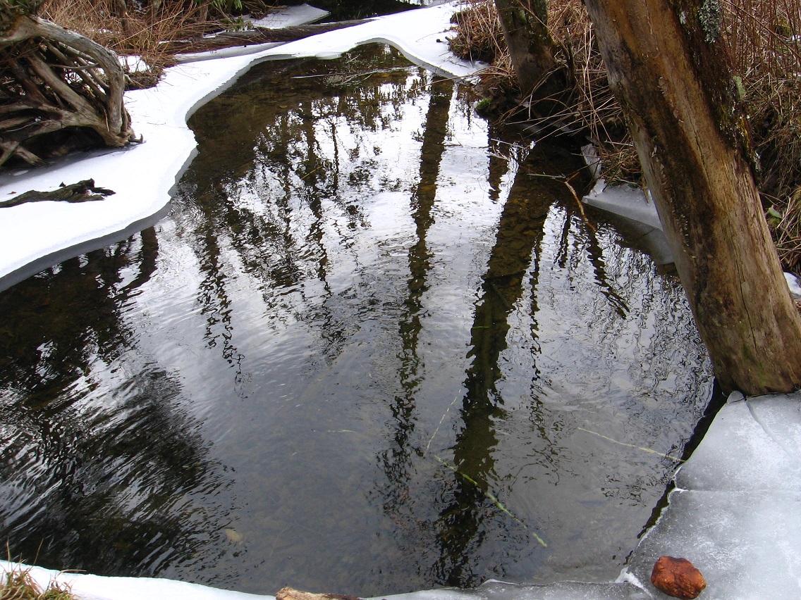
Red rock wasn’t on the ice when I passed it the first time. Upon returning about 15 minutes later, it was there, prominently displayed. I don’t believe there’s any way I could have missed it.

IMG_0101smaller

IMG_0102smaller

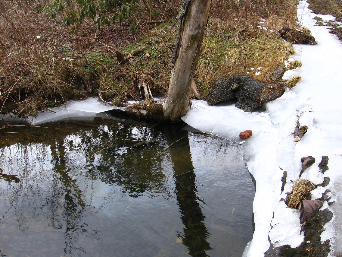
The approx. 4 foot long ice flow that I broke off with a stick at the time *wasn’t* present, even though there appeared nowhere for it to go in the meantime. The piece broke off only several feet down from the red rock.

IMG_0104smaller

The wife and I got a laugh out of this when I told her about this aspect of the mystery, because it instantly reminded us of the Might Boosh jingle “Ice Flow, Nowhere to Go”, which we sing on occasion to cheer ourselves up during very cold weather. Do the Bill Mtn. aliens have a heightened sense of humor as well?

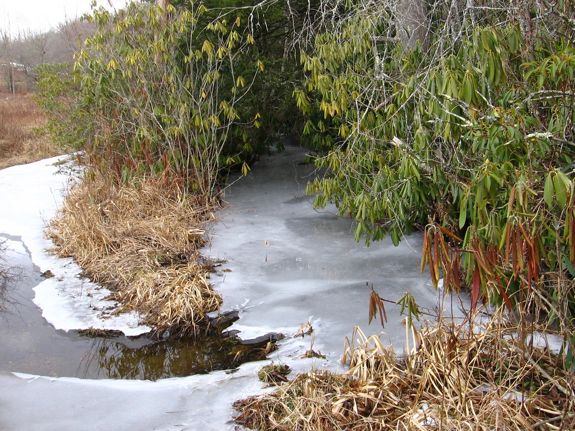
Nearby frozen P Creek. Frozen peas — hmm. Almost identical in angle to the last photo from this earlier F&HE! blog post from almost a year ago.

IMG_0105smaller

IMG_0106smallest
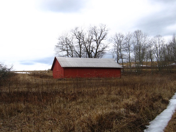
Neighboring red barn. Red again…

In the very next blog post…

https://bakerbloch.wordpress.com/2013/02/25/so-2/

… Hucka D. psychically seems to hint at the manifestation of this future red rock. If so, it could also be connected to the future development of Epsi with its matching black and white rocks.

Hucka D.:

There’s two things to look for…

bb:

Land and water?

Hucka D.:

The black rocks, the white rocks. Black and white. (pause) Red.

Theory:

The Bill displaced Herbert, Alabama from Conecuh County to Butler County to be near Saucer and Forest Home. A particular geometric arrangement was even established, Fake Herbert, as we’ve been calling it, the same distance from Forest Home as Saucer. Herbert stands for Frank, as in *Frank* Park, home of Bill Mountain. We are now calling the aliens The Bill. Again: Fake Herbert, Alabama was set up by The Bill. They were indicating that Bill Mtn. is their *forest home*.

That Herbert was moved from near Paul to near Forest Home means that an attachment to author Frank Herbert and his Dune starring seer Paul Atreides has been removed, or perhaps *carried over*. This is now a Frank Park/The Bill issue. End and beginning of two, separate Cardinal Roads is also thrown in the mix. Together they stand for the beginning and end of the *middle* third of Baker’s Creek, Mississippi. They are at the 1/3 and 2/3 point of the creek from mouth (Port Gibson) to source. They emphasize *Cardinal Gibson* (Bob).

Red Rock is a summary point of Black Rocks and White Rocks, US of A. What’s black and white and red all over?

1 Comment

Filed under Alabama, Bill Mountain, Frank Park, MAPS

Hand holders, part 11

colbertal01

It’s been a rather long year. Exciting (!), but long. Guess I’ll wait for a summary until the 1st of Jan. or so. What I might be shifiting into currently is a bout of research on UMapS. What is UMapS? the reader might or even should ask here. Well…

Hucka D.:

It’s a system devized by Lisa The Vegetarian to coordinate different synchronicity systems. It’s like Chinese [nested] boxes, but a smaller box can nest a larger box. It’s 4d. Like your Corsica continent. Where is Bracket Jupiter on the history[ of that]?

bb:

Unsure, Hucka D.

Hucka D.:

Pennsylvania [UMapS energy] is continued or nested in the Corsica Continent, Your Second Lyfe (or My Second Lyfe or His Second Lyfe). Corisca is, then, a bridge between reality reality and second reality. And Heterocera (continent where we reside virtually, currently) is hooked onto that. They are yet another form of hand holders. And since Bracket is from East VWX Town and Edwardston is from the West, then their joined histories are also the joined nature of the town. Darn cats!

—–

bb:

This is not Bracket Jupiter’s “History of Corsica”, but it could be related:

97795h8_27

Hucka D.:

What actually happened in Ratcliff with All White Horses [ Are One White Horse]? How did the King and Queen get there from Wiltshire, England? What was sold in the store? I think you want to say tiles. Microcosms. How did the Ratcliff hole form, and what does it have to do with crop circles? The King made a specific crop circle as a black hole, connecting dimensions. It acted as nested and nester in one. What happened in the Ratcliff central court? — a King must have his court, after all. Is the Wiltshire King the same as the Bracket King, or Bracket Jupiter or King of the Stans? Which came first, the Head or The Trip? Things like that.

bb:

It’s another element I’ve thought about: humor. In the blog here, we solve problems through [more readable] humor. It seems to work, yet it also seems that we’re spinning wheels a lot. We talk about writing the history of joined Corsica and Heterocera continents, but when to start and where?

Hucka D.:

Here. Now. You know the Lindens passed through and agreed to the formation of the Ratcliff Hole, allowing Bracket Jupiter to travel between the two continents easily. The Pond District was[ kind of] sealed off from the rest of Heterocera at that time, to protect the innocent… no, to protect the integrity of other parts of virtual reality on that continent. The ponds of the Pond District *should* have connected to the Heterocera Ocean (ocean surrounding the continent) but didn’t. A kind of second virtual reality was nested within the first, but, then again, nested is also nester. Where did this all start?

Bracket Jupiter:

The Forest!

Hucka D.:

Yes Bracket J., the forest. The Rubi Woods. But it was the Sylver Forest, larger, at that time. Jack Nicholson stares at the Sylver Forest in The Shining. Plain and simple. He too, the character he plays also called Jack, is attempting to go back into the past, a better place. Black was separate from white in the playing of “all the best people.” Colors knew their place, like Mayberry. On/off. The Head and The Trip.

bb:

So much spinning wheels, Hucka D.

Hucka D.:

Maybe. How do you logically write, however, about nested and nester as one? You really can’t. It must be fiction. It must be characters, you and me and others, interacting and talking with each other. You reach a dead end — you make a joke.

shine03
Or insert a picture.

Snapshot1605_001

1 Comment

Filed under Alabama, MAPS

More Alien Information

http://centreportal.blogspot.com/2008/10/oz-born_17.html

Quote (my emphases):

Image: An aerial view of the 1st Igniting The Fire Gathering at Manito Ahbee in the Whiteshell provincial pARK. The Circle and dot is the sacred fire that was lit as part of the gathering. As Cree Elder Don Cardinal explained to me – it was the 8th Fire of Life. The 7th Fire was the human fire and it was almost extinguished. So this gathering and sacred fire ceremony was designed to use the 8th Fire ceremony to re-ignite the inner fire of Humanity. This is the gathering that Juan and is wife Sandra came to Canada to attend.

DPP07D60912173526

This appears to be the first so-called synchromystic related post of the Centralportal blog. I stumbled across it while doing a google image search for “circle with dot in middle” to be used in combination with the maps below, which I’ll get to in a moment. Here’s the image:

monad

Also here’s a slightly later blog post, mentioning a circle with *cardinal* points.

http://centreportal.blogspot.com/2008/12/tie-creek.html

But to my map pictures created today. In the first, I attempt to illuminate the fact that Saucer and Fake Herbert are equidistant from Forest Home, or a distance of 2.8 miles. Fake Herbert is discussed in this earlier post a bit: when you look up Herbert AL in the GNIS database you are directed here instead of the actual location of Herbert in this state, which lies about 28 miles south in neighboring Conecuh County.

foresthome01

As I scanned this 2.8 mile circle in continuing around Forest Home from Saucer and Fake Herbert, I eventually unveiled two, different roads named Cardinal — Cardinal Road both. I should add this is a sparsely populated area with few marked roads. For the upper or northern (or western) Cardinal Road, the beginning point seems to be highlighted by the circle. For the lower or southern (or eastern) the end of the road is instead apparently emphasized by the same. I thought this beyond chance.

On the maps below, each Cardinal Road is represented by a (cardinal) red right angle, with the hypotenuse of both roughly giving the length of the road. While nothing (yet) came of the actual measurements of the roads, my thoughts turned to other Cardinal references in UmapS, and, shortly, Baker’s Creek, Mississippi with a Port Gibson just beside its mouth.

foresthome02

Here’s some further research into this. The latitudes of both the Cardinal Road Beg(inning) and Cardinal Road End points on the Forest Home 2.8 mile circle both happen to cross the approx. 10 mile long Baker’s Creek in this neighboring state. Where the Cardinal Road Beg latitude line crosses the creek is 3.11 miles below its mouth (beside Port Gibson). Where the Cardinal Road End latitude line crosses the creek is 3.11 miles above the source of same, this source point being determined beforehand. The distance between the two places where the latitudes lines in question intersect Baker’s Creek are 3.31 miles apart, seeming to divide the creek into 3 symbolically equal parts, then. Is this the meaning of the “333” cloud in Gila’s collage 02, especially given that each line is a little over 3 miles long, and 1/3 equals 0.333…? Notice also that the “Cardinal Road End” point on Baker’s Creek is situated almost on a county line. Basically speaking the first 3rd of Baker’s Creek is in Jefferson County, MS and the upper 2/3rds in Claiborne County.*

Further thoughts:

The 2.8 mile Forest Home, AL Circle emphasizing Cardinal “beginnings and endings” is meant to be the same as the Manito Ahbee circle pictured at the first of this post, where the 8th Fire of Life is now burning thanks to a 2006 celebration led by Cree elder Don Cardinal.

I’ll get to the whole Port Gibson-Cardinal association later on. I promise.

foresthome03

foresthome04

foresthome05

—–

* The first and third heads in front of the house of Gila’s collage 02 are also identical, like the 3.11 common length between the 1st and 3rd parts of Baker’s Creek, as also defined by the Claiborne-Jefferson County line. The middle head is instead turned the opposite way, indicating it is a bit different, though still squarely in the middle. Have we now entered the inner sanctum of Apricot Bone? Does the solar related crop circle to the left of this collage represent the Forest Home circle with its own symbolic inner fire thanks to recent efforts of Don Cardinal?

Foreset Home Circle

http://thelamplight.ca/schematicgod/ancient.htm

Is Baker’s Creek like Tie Creek, a needed feminine balance to the Forest Home solar circle in neighboring Alabama? Could very well be. Obvious resonance with Ti*l*e Creek as well.

http://thelamplight.ca/schematicgod/orbs.htm

4 Comments

Filed under Alabama, Bill Mountain, Frank Park, MAPS, Mississippi

Pine Apple

But it’s *Herbert* that’s not where it should be. Like Frank Herbert, and representing Frank Park. The Saucer belongs to the Frank Park aliens. It is their Forest Home. (pause) Herbert should be miles and miles away in Conecuh County instead, nearer Paul. I don’t think Hucka D. is going to help me with this one. It must relate to Dune’s Pain Box just brought up in a post composed earlier today. Let’s see…

herberttowns
The first Herbert is in Conecuh County but not on the Forest Home topo map, which instead covers part of neighboring Butler County to the northeast. The distance between the Herbert indicated in GNIS in Butler County and the actual Herbert in Conecuh County is about [appears to be about 20] miles.

The wrongly located Herbert appears to be “on” Pineapple Highway, and pineapple came up in one of the more unfunny jokes of The IT Crowd episode we watched last night, which kind of stood out because the show is so funny overall. It concerned pizza with pineapple topping. Could “pineapple”, then, be another clue. I automatically think of SpongeBob SquarePants’ home under the sea, not a forest home but a sea home, and SBSP is sort of an alien, I suppose.

spongebobs-house
(Is that Master Shake in the background?)

Saucer is also on Pineapple Highway (in reality this time). Odd name for an Alabama highway… don’t think they grow pineapples there.

Hmm, turns out there is an actual town named Pine Apple that this highway leads to from Saucer. Cute… both a Cherry St. and a Banana St. in the handful of town streets.

herberttowns02

That’s the only Pine Apple or Pineapple pop. place in the US.

http://en.wikipedia.org/wiki/Pine_Apple,_Alabama

So add this town perhaps to Apricot, Washington as fruit villages of blogg’n significance. Interesting perhaps that one of two noted residents of Pine Apple listed in the wikipedia article is Fred *Cone*, like a pine cone. I think of the many pine cones in Little Witshire, Frank Park here. Fred Cone was a former NFL running back for the Green Bay Packers and Dallas Cowboys. I also think of Herman Park here for obvious reasons I won’t divulge. I further think of *Cone*cuh County and the actual location of Herbert, Alabama.

604ec08fdc1a4f153cf39bba8243a7e6
Hmmm.

5 Comments

Filed under Alabama, Bill Mountain, Frank Park, MAPS