Category Archives: MAPS

Marbles 02

TEXT SOON.
castle01

castle02

castle03

castle04

https://en.wikipedia.org/wiki/Elvis_Presley

Presley was born on January 8, 1935, in Tupelo, Mississippi, the son of Gladys Love (née Smith; April 25, 1912 – August 14, 1958) and Vernon Elvis Presley (April 10, 1916 – June 26, 1979),[12] in the two-room shotgun house built by Vernon’s father in preparation for the child’s birth. Jesse Garon Presley, his identical twin brother, was delivered stillborn 35 minutes before him.[13] As an only child, Presley became close to both parents and formed an especially close bond with his mother. The family attended an Assembly of God church, where he found his initial musical inspiration.[14]

“There can be….

… little doubt

MORE TEXT SOON.

coalcounty

https://bakerbloch.wordpress.com/2014/10/22/owl-centrahoma/

Jesse_Pinkman2
Better call Saul!

Special:

nicholson01

*Jack’s son* (Daniel, or Danny) is special.
Shines. Like moonshine.

moonshine01

Leave a comment

Filed under Illinois, MAPS, New York, Oklahoma, Toy Avatars, West Virginia

Bigfoot 01

100 Foot Swamp:

bmul010

8/31/15:

100 Foot Swamp has been renamed Bigfoot Swamp, a natural transition (it has a “big” feet of length). The projected town or “toy happening” around it becomes Bigfoot then, most likely, with a center near the northern part of the marsh, where a feeder stream enters it via an uphill pipe.

The only US population place named Bigfoot presently is in Frio County, Texas. The general area of this village has already been seen in a map displayed on this blog from May 2014 called “Strange 01″…

https://bakerbloch.wordpress.com/2014/05/15/strange-01/

There I discuss the conjunction of two towns in Medina County to the immediate north of Frio, or Noonan and Devine. Glenn Strange plays the bartendeer Sam Noonan in the long running western seris Gunsmoke featuring James Arness and sheriff Matt Dillon, an icon for our time. The town Noonan in Texas is one of only 2 in our US of A, the other being in Divide County ND and near a *Strange* Siding. Noonan and Strange conjoined again. Near Noonan Texas is a city called Devine. There are only two pop. places of that name as well, with the other being in Colorado near a Vineland, and itself having a variant name of Vineland according to the GNIS database.

Notice several things here in addition to the stuff I outline in the “Strange 01” post: Divide (County, ND) is almost an anagram of Devine. I now work with a guy named Devine, who is sort of my boss as I perceive him. He cryptically emailed me several times on the weekend I discovered the Bigfoot Swamp. Now I find the only US Bigfoot conjoined with the only incorporated US Devine, and the only one of any significance. Bigfoot Swamp, a natural area bordering the Blue Mountain Urban Landscape and what could be considered a direct extension of it (that’s how I view it anyway), can stand for the event *furthest* away from this Urban Landscape in the Blue Mountain area, or the encounter with a Bigfoot like creature in the furthest recesses of Frank and Herman Park the winter of 2012/2013. This is an encounter with a completely *alien* culture, seemingly, and as far away from humanity as you can get. It is non-human. It creates not stuff we humans consider normal, like roads and houses and malls and hospitals and HugeMarts. So the near Bigfoot (Alpha) overlaps the far Bigfoot (Omega), and perhaps in ways I cannot understand yet (involving Devine?).

On the below map we see the close conjunction of Noonan, Devine and Bigfoot in Texas, with the word Devine strangely absent on the map despite being a town of significant size. Represents the soon absence of the other Devine? Maybe. If so, what name will take its place? Is that written out in maps as well?

MedinaCountyTexas1940sb

Bigfoot, Texas:

https://en.wikipedia.org/wiki/Bigfoot,_Texas

Leave a comment

Filed under BIGFOOT, Blue Mountain, Colorado, MAPS, North Dakota, Texas

Roach 02

A picture taken from almost the exact position marked in the first photo of the post immediately before this. Needless to say I didn’t take it from Roach Missouri. I snapped it because of the interesting perspective of The Hill we have here (center background), juxtaposed with the faded sign of “The Carpet House”.

IMG_0188smaller

roach03
The House on The Hill 01

Instead of moving to The House on The Hill, we have to eventually visit The Carpet House, which acts as a stand in here for our present house (The Home on The Ridge). We have to carpet our present house.

1 Comment

Filed under Blue Mountain, MAPS, Missouri

Roach 01

roach01

https://en.wikipedia.org/wiki/Roach,_Missouri

Camdenton contains the same number of letters as Chameleon, and both start with a “c” and end with a “on”. Certainly this 8.1 acre piece of property is disguising itself within a listing 1000 miles away(!). But why? The most logical guess is that it reinforces the name Roach in the area, as in my former manager at the Maynard Jackson cafeteria. Impossible, you say? Let’s look at the place name Roach across our fair US of A…

Well do you, fair *reader*, remember that not one but several maps of this same Camden County are featured in a post of the old Baker Blinker blog? I just did. It’s also mentioned in the 2014 hybrid document “Map Sinking Feeling” — you can just do a search for “Camden” within the full text version to find it (connected there with a perhaps also imaginary Winona Falls).

I think we could be starting down one of those bunny trails rabbit holes again into hyperspace/time, turning the world upside-down as it were.

—–

In looking up Roach Missouri on topo maps, quickly found a *Laugh*lin Cemetery to the east, and then almost directly across the lake (Lake of the Ozarks) from it, a *Ha Ha* Tonka State Park. Are the hyperspace/time “rabbits” having a hearty giggle with the disparate Roach locations?

Ha Ha Tonka State Park history:

https://mostateparks.com/page/54968/general-information

Interesting that the “Boones” were there, since we have overlapping roads named Boone Docks involved in our Zillow generated map paradox.

Sounds like a fascinating state park! Several sinks within. 😀

hahatonka_castle_1930's_600dpi_cropped

2 Comments

Filed under Blue Mountain, MAPS, Missouri

Collage 10 Interpretation 02

(continued from)

In part two of Collage 10, now called “Holey”, we see two namesake types. First is an actual hole — or half hole, really — that appears on the ground before a now leaning 12 Oz Mouse on the far left side of the collage.

Snapshot2035_006

I’ve limited the view here to the left side of Collage 10, focusing in on the 2 “holey” images themselves. Now the second one is something “holy” instead of “holey”. The most holy thing for many, in fact. This is the image of Baby Jesus appearing with Brak now. He cradles the illuminated infant in his berobed arms. It strokes his queer yellow beard. He becomes yet another father in this manner: St. Joseph, father of Jesus. This image is first found in my blog from last fall here:

https://bakerbloch.wordpress.com/2014/10/03/2-st-joes/

joseph02

In this same post we have a picture of the Maumee River basin, this stream formed by the conjunction of St. Joseph and St. Marys rivers at Fort Wayne, Indiana. You can see why I associate it with Jesus, then. The Holy Infant confuses his father for his mother. He is just a wee lad, not much removed from tadpole status. But is this his father, see? Isn’t God the Father? And so forth. So these 2 “holeys” appear on the left side of Collage 10, defining the tone of the picture reading it from left to right.

Maumeerivermap

The Maumee River basin has showed up in a prior Stonethrow collage, or Collage 06 (“Beware (The) Heelers”), part 02 of the 2 section animation to be exact. There it’s covered by what’s called the Great Black Swamp, drained in the early to mid 1800s by settlers to the area.

wheelers15

You can again see Fort Wayne to the left and Toledo, at the Maumee’s mouth, to the right. The whole of the Maumee River was apparently submerged in or made one with this giant, dark marsh before the Great Drain. Very peculiar — and I didn’t know about this swamp until several months after creating that October post. I had other reasons to be drawn to that area (Rainbowology).

The image of the Great Black Swamp here covers the word “The”. The second part of the Collage 06 animation becomes just “Beware Heelers” instead of “Beware The Heelers” of part one. Collage 06 also contains a number of other Rainbowology elements, including Dorothy Gale, the Witch Mombi, and Ozma, all characters from Baum’s Oz mythology later found in the movie “Return to Oz”, the base for the earlier carrcass “SID’s 1st Oz” from 2002. The basic point of Collage 07 is that Ozma as true ruler of that fantasyland is able to symbolically drain the Great Black Swamp again by reversing Dorothy’s Fall highlighted in “Dark Side of the Rainbow”. This is the same as Dorothy (and Oz itself) being saved by TILE, a religion that has replaced X-ianity for me by becoming as much a philosophy and a board game as a religion per se. “Per se, Hucka D.” (pause) Not there.

Snapshot2035_009

And then on the *right* hand side of Collage 10 we again have the image of Dorothy falling off that confounding pigpen fence, animated this time. The second animation (below picture) shows Dorothy more in the actual state of falling, and this image again directly comes from Collage 07. The first Dorothy (above picture) is more in the process of losing her balance on this fence, causing the fall. “But through the magic of the collage, she instead falls off the roof of this white house, Hucka D.” (pause) Hmmm.

Snapshot2035_008

The orange m&m has “reappeared”, looking very concerned again like he did as a pendant image in the prior “Darth Redder” collage of this tetraptych. But this m&m, and his accompanying smaller rainbow colored clan of same tagging along behind him and then in front of him (as they too seem to fall) are actually a part of Collage 11, after Collage 10. I call this final collage of the tetraptych “Rainbow Men.”

Hucka D.:

This time we must now move quite yet into an interpretation of your Collage 11 beyond Collage 10 but focus on the latter. And good morning to you.

bb:

Thanks Hucka D. And thanks for showing up again to help me with this difficult and complex interpretation…

Hucka D.:

… of a difficult and complex work. But it’s not that complex. Just keep your thumb next to the line you next recite and you’ll do fine.

bb:

Stick to the [already written] script, eh.

Hucka D.:

Precisely. Now what are your next lines? Because you’re next up.

bb:

Tadpole?

Hucka D.:

No. Read the line to the *left* of your thumb instead of the right. You’re always confusing those directions. At least you usually get up and down right the first time. Or is it left?

bb:

We must focus on the White House.

Hucka D.:

Good. You’ve already established a racist lives there and that racist is Brak The King from Temple Farm, Marlborough, as featured in the Baker Bloch Heads To England exhibit from 2010, I believe. Blochhead. Bloch-head.

bb:

But you’re also saying that Brak represents the great loser state of Arkansas, or perhaps he hails from there.

Hucka D.:

Hell.

bb:

And you’ve always told me, ever since the beginning of my blogging days in the old Baker Blinker one, that Arkansas is the center and the focus and not let my attention stray too far north. Or *up*.

Hucka D.:

Down is where it’s at, yes.

bb:

Do you want to explain this further? I mean, just looking at [Collage 10], we have a dog stuck on the side of a wall — this is a Little Whitehead Art Collective creation once more — with a miniature Patrick Star of Spongebob Squarepants looking on with ice cream cone in hand. He’s just a big kid through and through. Then an even tinier Spongebob emerges from his pineapple home. (pause)

Hucka D.:

I can’t see that far down.

bb:

Here…

collage10test21d

Hucka D.:

Thank you[ for showing me the whole picture]. “Holey”.

bb:

Patrick Star appeared in the Falmouth tetraptych that completed the 2013 Gilatona-Lis sequence of collages, Hucka D.

Hucka D.:

I remember. Vaguely.

bb:

Well, here he is in case you’ve totally forgotten.

falmouth04final05

Hucka D.:

Thanks once more. But if you’re going to rezz that whole [older] tetraptych then we’re going to have to stand back a bit.

bb:

Then I won’t do that.

Hucka D.:

Thanks yet again.

bb:

And Spongebob also showed up in earlier Gilatona-Lis works. And his pineapple home appears in the original Embarras collage (Embarras 01).

Hucka D.:

“Why?” I hear you asking in your mind. Well, to give the collages a bit of levity for one thing. The dog flies into the white house and becomes stuck like in flypaper. I must ask you: is this dog Spider? Carrcassonnee’s Spider that still sits in the Collage Temple beside his master, still spouting out the permutations of that hellish number 2130?

bb:

He’s not exactly the same color but it does appear to be a Chihuahua of similar shape and size. And Patrick Star hates Spiders — that’s another connection.

Hucka D.:

Maybe we better end on that humorous note. Yes, the dog is Spider. Yes, that’s why Patrick Star is there. Mr. Star is also a crop circle, as is Spongebob Squarepants… as are their 3 houses in a row if you throw in “trapped in the middle” Squidward and reduce all to the base of Patrick’s rock. [That’s all Morgan Hill crop circles.]

10903829

25505704

bertjanssen-morganshill2011

-The-Spongebob-Squarepants-Movie-spongebob-squarepants-16980886-1360-768

bb:

Fantastic. Here they are [off the road to Honeystreet, UK]…

llistest17

http://fineartamerica.com/featured/morgan-hill-crop-circle-reconstruction-raul-castellar.html

(continued in)

2 Comments

Filed under collages 2d, Indiana, Lake District, MAPS, Ohio, United Kingdom, Wiltshire

Red Umbrella

I believe the new collage series may be basically finished with the creation of “Triumph of the Toys”, a simpler composition. I’ll continue to interpret the tetraptych that came before this tomorrow. And I have a name for the series: Stones Throw. This comes from what appears to be the only legitimate golf course in Jasper County, about 4 miles west of the county seat of Newton. The appellation is in line with the naming of the other 2 series within the Red Umbrella, which also involve locations near this town (Sam Parr (State Park) and Embarras (River)). And what I really like about the name is its similarity to Stonethwaite, a UK location which dominates the Stones Throw series toward the end (tetraptych and then “Triumph of the Toys”). I might even call it Stonethrow to make the association more obvious, this word beginning with the same 7 letters as Stonethwaite.

Anyway, it’s all bleed’n coming together. The Red Umbrella Gallery is also essentially finished. Will I stay next to the Rubi Forest now all that’s over? The development of Collagesity has gone hand in hand with the evolution of this gallery and its 3 series. At the beginning of June, the virtual village will be one year old, although its existence spans two different locations (Noru and then Minoa/Rubi). I still have a considerable number of prims to play around with on the property. Is there more town myth making in the near future?

The other option I have is to disband the town and take the completed Red Umbrella to a new location, perhaps renting a smaller piece of property at least for a while to save money. But, if so, I’d like to take the larger Falmouth Gallery with me as well at the very least. And I would miss all the rest of Collagesity for sure. But is the potential downsizing worth saving, say, 30 dollars a month? I can see going both ways. Typical. 🙂

At any rate, I believe I’ll get rid of the abridged version of the Red Umbrella in Mysten within the week. I can’t rezz a gallery kiosk there.

Snapshot2031_002
front entrance, The Red Umbrella gallery (rain)

Snapshot2031_004
back entrance (fog)

stonesthrow01
Stone’s Throw Golf Course near Newton, Sam Parr (State Park) & Embarras (River)

Leave a comment

Filed under **VIRTUAL SL, Heterocera, Illinois, MAPS, Rubi

By Neptune 01

Sign for Neptune. Mirrors the Trident streams in extreme western Frank Park, and also Herman and Frank Parks taken together. But Neptune is unseen by the remainder…

470px-Neptune_symbol.svg

n_a-1

… until Gene Fade reaches fabled Red Head and builds a dwelling place on the “northern” shore and calls it Neptune (or North Star). All that was unseen becomes seen with (one of his biographies), entitled “By Neptune’s Beard!”. Neptune becomes the outermost planet of our Solar System starting in 1846. It is the only one that cannot be C-een by the naked eye. It becomes a symbol of the darke night sky, then. Carrcassonnee.

Beyond the planets and into the darke night: stars. All revolves around North.

darke_county_ohio

http://en.wikipedia.org/wiki/North_Star,_Ohio

North Star was platted in 1852[6] along the road between Greenville and Celina, approximately midway between the two cities. Its name was derived from its location on the edge of the Great Black Swamp, as it was the northernmost point in Darke County that was not wetland.[7]

The Great Black Swamp is The Abyss, the static nothingness of the Universe all around us and through us and into us. Only TILE saves. TILE is the effect of the C-een planets on the nothingness. Tennessee.

But then, beyond TILE is Still(water) and beams of light.

http://www.oldielyrics.com/lyrics/syd_barrett/long_gone.html

And I borrowed the page
From a leopard’s cage
And I prowled in the evening sun’s glaze
Her head lifted high to the light in the sky
The opening dawn on her face…

Charles Ives” “The Cage” with lyrics.

Annie Oakley is from North Star.

http://en.wikipedia.org/wiki/Annie_Oakley

Annie Oakley (August 13, 1860 – November 3, 1926), born Phoebe Ann Mosey, was an American sharpshooter and exhibition shooter. Oakley’s “amazing talent”[1] led to a starring role in Buffalo Bill’s Wild West show. Her timely rise to fame[2] allowed her to become one of the first American women to be a “superstar“.

“By Neptune’s Beard!”

http://stellareco.com/

Great Black Swamp:

http://en.wikipedia.org/wiki/Great_Black_Swamp

GreatBlackSwampMap
Chattanooga

In the 1850s the states began an organized attempt to drain the swamp for agricultural use and ease of travel. Various projects were undertaken over a 40-year period. Local resident James B. Hill, living in Bowling Green, Ohio, in the mid-19th century, made the quick drainage of the Black Swamp possible with his invention of the Buckeye Traction Ditcher.[6] Hill’s ditching machine laid drainage tiles at a record pace. The area was largely settled over the next three decades. The development of railroads and a local drainage tile industry are thought to have contributed greatly to drainage and settlement (Kaatz, 1955).

Leave a comment

Filed under Indiana, MAPS, Ohio, SID's 1st Oz

“Confessions of a Rainbowologist”

I’m going to begin thinking about this potential work. It might start in 1977 when I landed a job at the Land of Oz theme park cleaning bathrooms and painting birdhouses and sweeping the yellow brick road. My best friend played the Scarecrow. He introduced me to one of the guys acting as the Cowardly Lion of Oz who was also part of a local G. I. Gurdjieff teaching group. We started attending, and soon learned of the enneagram, claimed to be a universal model. Much later I found what appeared to be a version of it in Dark Side of the Rainbow that “completed” this best known audiovisual synchronicity — filled in the missing central triangle. It might also represent a way I could finally start to understand the symbol’s meaning. Illusion? Perhaps. But what are the chances that the *Cowardly Lion of Oz* would again be directly involved?

edwards

Leave a comment

Filed under Illinois, MAPS

i c planets

A follow up to LINK.

MORE TEXT SOON.
n_a

n_a-1

n_a-2

n_a-3

n_a-4

http://en.wikipedia.org/wiki/Five_Civilized_Tribes
(4 c’s and an s (Seminole)).

785px-Trails_of_Tears_en

—–

Joyce, your sun return chart didn’t show up in the post you tried to
put an image of it in. Can you perhaps put it in the photos section
or create it as a file for the files section? As you have seen, I
just create my graphics and then ftp them to a specific web directory
that I created just for this purpose.

If you wish, you can email me the chart and I can then move around to
a designated spot.

Thanks for the clarification about solar vs. sun return chart. Talk
as much as you want to about it, and I’ll check up on it more myself.
I understand what you’re saying: sun position is the same, but the
planets will have moved around and created different aspects or non-
aspects.

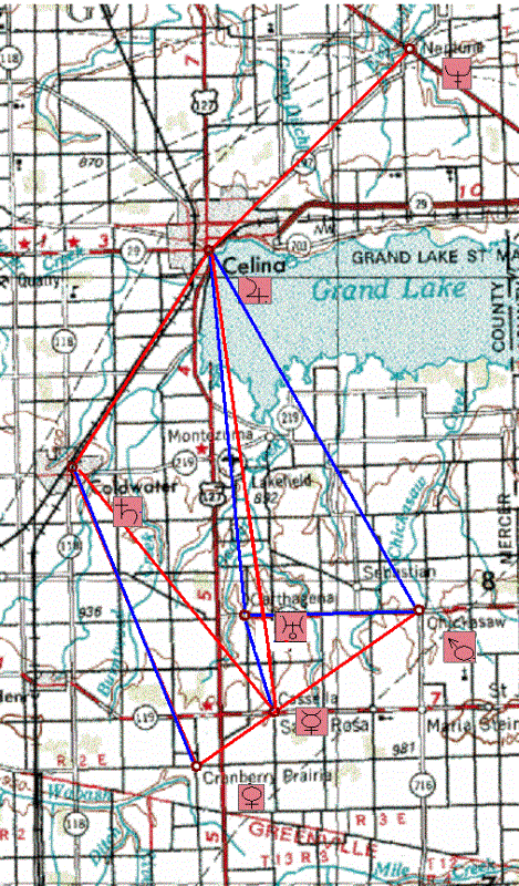
The reason I find this, among other things, interesting in the
present situation is that it did occur to me that the “C” towns might
be representations of planets. Like a trait of the “C” towns (what
should we call this little diagram?), the outer planets, which are
further apart, tend to be larger, and the smaller inner planets
closer together. A logical association would be Celina, the largest,
for the largest planet Jupiter,

then, and Coldwater (2nd largest) for
Saturn (2nd largest planet).

If so, the rest would correspond, in
some way, perhaps to inner planets Mercury, Venus, Earth, Mars.
Perhaps subtract Earth from this list from further info I will give
below.

Another clue to this possible alignment of associations is the
presence of a town called Neptune nearby, just to the NE of Celina.

Joyce, I just looked at the other post from you I had open in another
window, and *just saw now* that you mention Neptune in it as well, in
connection with the 1846 founding of Maria Stein.

Okay, I’ve read that post, although I’ll have to study it more later.
I didn’t understand a lot about the chart references, but maybe if I
have the chart in front of me, a picture of it, then I can see what
you’re saying better.

It probably doesn’t surprise you at all that
I’m more a visual person… have to see what you’re talking about in
order to grasp it… goes along with the art major and the
fascination with maps.

I grok, though, the association of 1846 and Neptune. I’ll study all
this further when I have more time, believe you me.

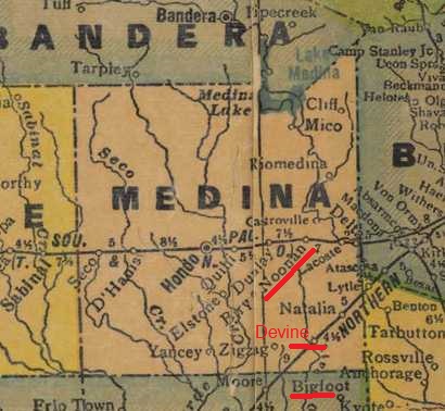
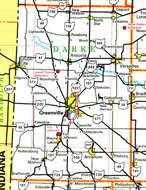
Here’s the map again where you can see Neptune just to the NE of
Celina. It also did occur to me that perhaps the “C” towns should be
viewed from the perspective of the Neptune town, making Celina Saturn
and Coldwater Jupiter, since Saturn is close to Neptune.

Another planet association we can make is that there are *6* visible
planets you can *see* (*C* resonation again)…

C = SEE

…and there are six *C* towns here.

If we go by magnitude of a
planet from Earth, the way we actually *see* it, then, Celina, the
largest town, might be Venus instead, with Coldwater being Jupiter
(Venus and Jupiter are the two brightest planets from Earth). Then
the rest would be Mars, Saturn and Mercury in some combination, with
Mars, most often the 3rd brightest planet, I believe, perhaps
overlapping the only other incorporated town among the bunch, or
Chickasaw. You can also see a 6th planet, Uranus, sometimes with the
naked eye, on a clear night and if you know where to look.

Neptune, in contrast, is totally invisible to the naked eye. Yet we
can *see* Neptune on the map here, unlike the names of the other
planets, although they may be implied indirectly, as I’ve indicated.
Pluto is even more invisible.

Planets have a lot of resonations with other things, including
musical tones, going back to the idea of the C towns “trapping” Maria
Stein in the SE corner of Mercer County, thus bringing in the singing
nun Maria von Trapp of Sound of Music fame into the, um, picture.

Also keep in mind that Maria Stein was first brought up in a January
post on the b_hive by myself, but in conjunction with Minster (just
to the east of Maria Stein), a town that both Dean and I spotted as
resonant with the name *Monster*. Stein is the last syllable of
Frankenstein (Monster), already reinforced in the Hidalgo County, New
Mexico cluster of synchs. So all this is tied into the Jasper County
synchs involving monster that we’ve talked before about on the
b_hive… all this is a continuation of some kind.

Joyce, you brought up Jasper Newton Daniels (Jack Daniels) and
Neptune together in a post as well before… the Jack Daniels
distillery founded in 1846?

Haveta check. Monstrous *Moonshine*
concept also connected here, obviously.

It also did occur to me that the positions of the 6 “C” towns here
may be a 2-dimensional representation of a 3-d object of some kind. I
don’t have a way to render this in 3-d and play around with it,
though. I’ll try to think about a model further.

So, bottom line for now, the “C” towns may make some kind of *chart*
of planets, perhaps like a zodiac chart. The presence of a town named
Neptune just above this group seems to reinforce the idea. These are
the 6 visible planets (the ones you can see or “C”) in some
combination, plus the first planet you can’t see (which shows up as
the actual name of the planet here on the map).

Is this association something dillusional and Neptuney, or is it real
and concrete (remember, also, that our own Dean use to live in this
general area, just east of St. Mary on the map, I believe, where he
poured *cement* for the foundation of a buildling he associated with
a b_hive on this board)?

So I think that’s enough to chew on for now, for both myself and
others.

So Joyce… your chart please. 🙂

Wild, any input?

Does this make as much sense as the Love+Lee=Lovely
diagrams I created before? Less sense? More sense? Less synchy? More?

I’d like to hear more the story about your involvement with astrology
as well.

—–

Leave a comment

Filed under Alabama, Florida, Georgia, MAPS, Mississippi, Ohio, Oklahoma

Grand Spot 03

shallowater01
Shallow( Water) – Friend, NE

godfather03
Blue Skies Mr.

Big Bob?

Leave a comment

Filed under MAPS, Nebraska