Category Archives: Texas

Ruby > Camp Ruby

There’s no doubt that Kenedy is John Kennedy, educated at Choate, shot by Oswald who was in turn shot by Jack Ruby. To hide the assoc. Kenedy gives one of its “n”s to Panama (of palindrome fame). Therein lies a nice mystery, and also we are back at Camp Ruby, likewise in Texas. I believe Camp Ruby is an enlargement of the westward Texas Ruby.

In the early 1900s many of Kenedy’s gunfighter’s shooting caused the town to be nicknamed “Six Shooter Junction”.

-Additional shots were fired from “the grassy knoll,” a small area next to the book repository, suggesting that there were multiple shooters.

Leave a comment

Filed under MAPS, Texas

Jack’s VW

http://www.tshaonline.org/handbook/online/articles/hnv16

VINEYARD, TEXAS. Vineyard is at the intersection of U.S. Highway 380, State Highway 114, and Farm Road 1156, on Beans Creek, two miles south of Wizard Wells and thirteen miles southeast of Jacksboro in eastern Jack County. The current community of Vineyard is the second of that name to be located in Jack County. The original community of Vineyard, sometimes called Old Vineyard, was founded by George Washington Vineyard in the 1880s. Water found on the property was unfit for drinking, but cured G. W. Vineyard’s chronic leg sores and eye disease. Vineyard received a post office in 1882, and in 1914 the name was changed to Wizard Wells. In 1890 the community had a population of 100, a general store, blacksmith, and a barber. A new community was formed two miles south of Wizard Wells, around the depot of the Chicago, Rock Island and Texas Railway, eventually called the Chicago, Rock Island, and Santa Fe, when it was constructed in 1899 from Bridgeport to Jacksboro. In 1915, when old Vineyard was renamed Wizard Wells, the new community centered around the depot took the name of Vineyard.

jackcounty01b

https://bakerbloch.wordpress.com/2013/11/21/new-2/

OMG: VWX Town!

shining brain beetle vw

One singular thalamus has the ‘v-shape’…2 together make the ‘w-shape’.
The literal peoples car…Volks-Wagen….’STUVWXYZ’ (VW alphabet order and XY 23 chromosomes)

sh_bathroomcrossfade
The Man Behind The Curtain.

wizardcubeani
The Wizard Cube; VW conjunction to the east again; involved W is first letter of WIZARD.

Directly east of Jack County, Texas we have Wise County, almost the same size and dimensions of Jack but with over 6 times the amount of people per the 2010 census.
Jack5
Jack Nicholson (Devil). tp-arb-bob2 Ray Wise (Devil).

Wise has also be compared with Wizard here.

Important here may be the town of Runaway Beach (close to Vineyard + Wizard Wells) on the west side of Jack, and also Chico and Alvord. Okay, maybe not the latter two, but still: Runaway Beach, which I think may refer to the song “Runaway” by Del Shannon, referenced in Tom Petty’s “Running Down a Dream”.

2 versions of a Petty, Texas have already been highlighted in this blog.

wisecounty02

Tom Petty’s “Running Down a Dream” might make a nice alternate soundtrack for Jack’s initial trip to the Overlook Hotel during the movie’s opening scenes, driving his yellow VW through the beautiful Montana mountains toward his caretaker position interview. And in fact, this is what happened.

Songwriters: Lynne, Jeff / Petty, Tom / Campbell, Michael
By Tom Petty, Jeff Lynne and Mike Campbell

It was a beautiful day, the sun beat down
I had the radio on, I was drivin’
Trees flew by, me and Del were singin’ little Runaway
I was flyin’

Chorus
Yeah runnin’ down a dream
That never would come to me
Workin’ on a mystery, goin’ wherever it leads
Runnin’ down a dream

I felt so good like anything was possible
I hit cruise control and rubbed my eyes
The last three days the rain was un-stoppable
It was always cold, no sunshine

(Repeat Chorus)

I rolled on as the sky grew dark
I put the pedal down to make some time
There’s something good waitin’ down this road
I’m pickin’ up whatever’s mine

1 Comment

Filed under MAPS, Qbrick, Stanley, Shining, The, Texas

Twins

thetwins01
http://www.sailblogs.com/member/blessedlady/?xjMsgID=275816

sbwwpnnj

This is a favorite place of mine. I’m sure that some people don’t even know it’s hidden in the depths of Port Ludlow. The entrance is between two small islands called The Twins that open onto a bay about the size of Quest Stadium. Anchorable depths provide for two, maybe three boats, but I was there alone. The dense woods on the steep shores are only moderately punctuated by the gardening of the homes that line the bay, so it’s still a relatively idyllic setting.

Another Dart besides 3 already blog recorded (Washington). Historical, however:

spokanecounty02

Matching Oklahoma/Texas set (reversed from above):

shayok02

(continue to)

4 Comments

December 20, 2013 · 1:53 pm

There

was also a lot of talk about a SID’s 1st Oz interview, Hucka D. You and I.

Hucka D.:

Damn I can’t get any sleep[ because of you]!

bb:

I’m trying to press forward with the momentum.

Hucka D. (rubbing big bee peepers):

It’s morning. The sun’s up. And I’m up. This is wrong.

bb:

It’ll be okay. I’ve been looking up the keyword “interview” in the Baker Blinker Blog. I was planning the Sylver Forest related interviews, then the Mike Casey interview came along, which was the only *real* interview completed. Then we were going to do the SID’s 1st Oz interview. We talked a number of times about it when I first came to Rubi in 2008. We kind of started it, in fact. We talked of “Dark Globe” representing a kink in the A-Z progression of tiles in SID.

Hucka D.:

I’m not quite ready to talk about that again.

bb:

That’s fine. Hold on…

snapshot587_016

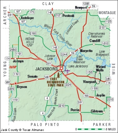
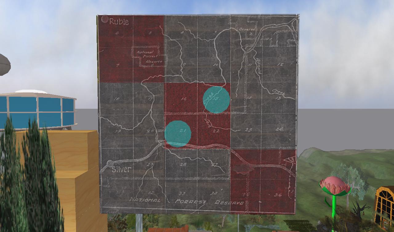
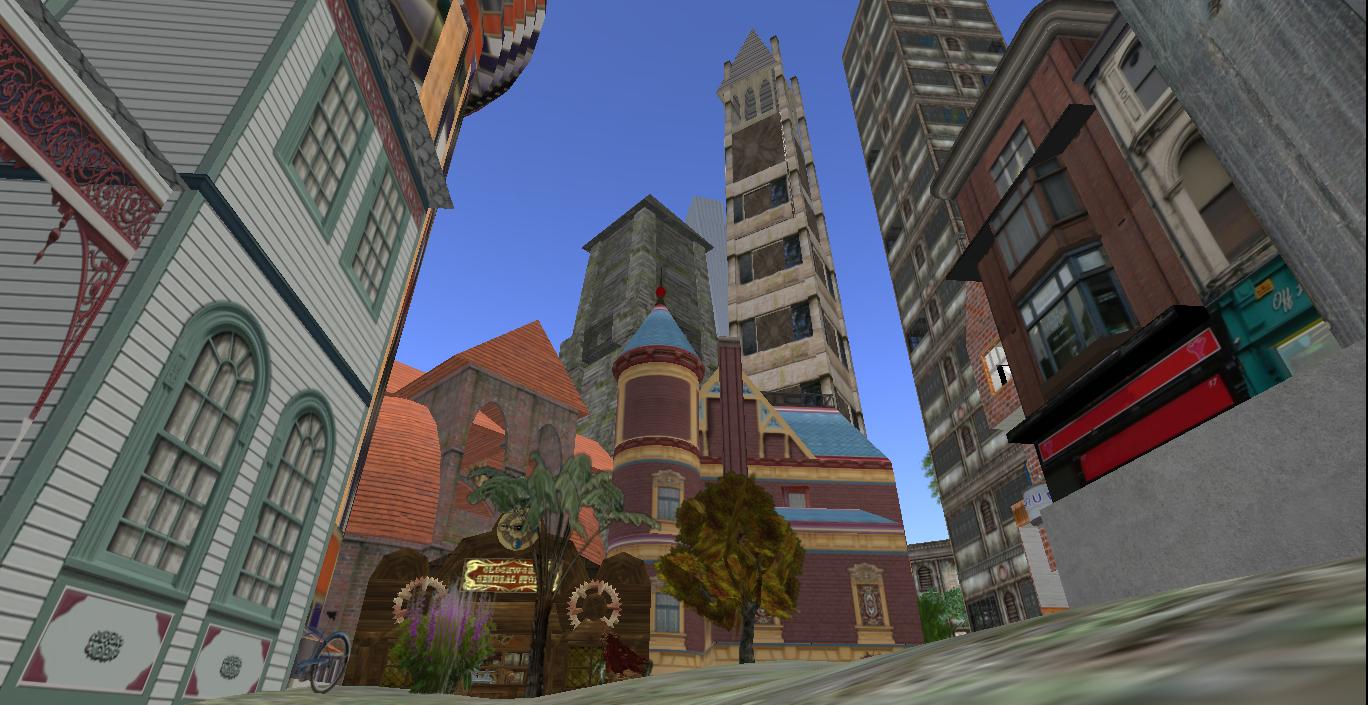
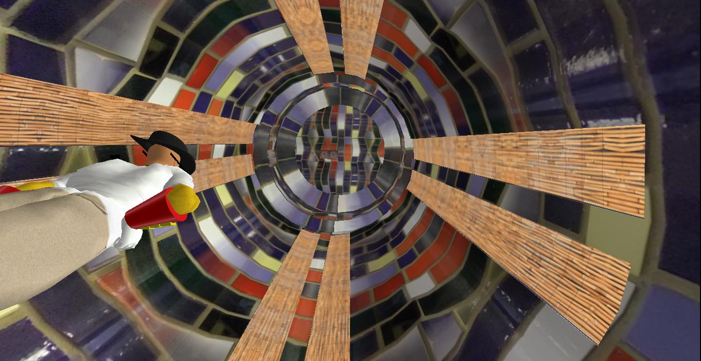
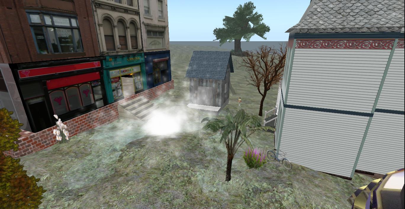
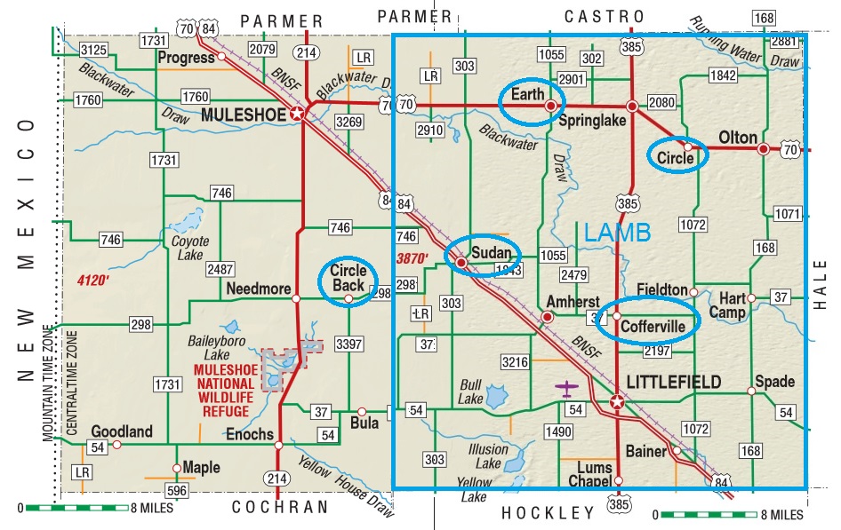
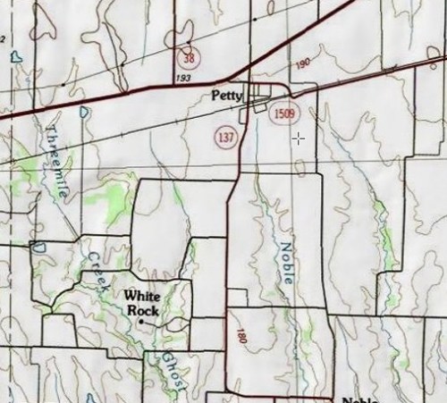
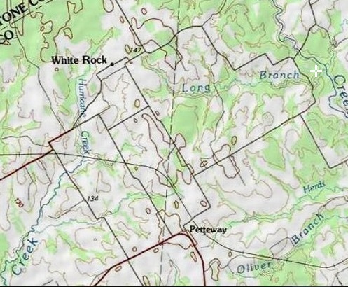
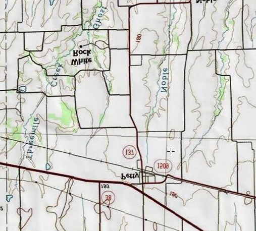
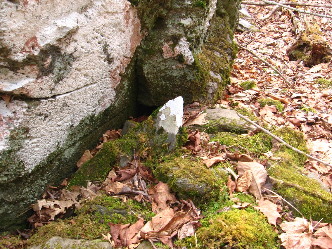
There’s the old front of the Temple of TILE in Rubi. This would be centered about where the Coolie Building stands now. It is a very telling front. In fact, this front is *still* in VWX Town — it’s inside the Tyle Cube revolving in front of the vacant Home Orange, Hucka D. Remember how Baker Blinker found it in ZicZac inside this cube and “unfolded” it? To me, in looking at it again, the red squares all stand for the Rubi sim that VWX Town takes up over a fourth of now. (no answer) That the 3 red squares lie on a diagonal, and resemble a game of tic tac toe, stands for *The* Diagonal that use to exclusively belong to Rubi until recently, when it was found to extend across the *whole* Heterocera continent. Exciting new Second Life development for this year fer sure. Hucka? Anyway, the fact that the rest of the squares on the map are Silver, and that Silver is the only other population place marked on this particular map…

Hucka D.:

There’s a plane! Over there.

bb:

In Nowheresville?

Hucka D.:

No. We’re suddenly somewhere. Like Ringo and The Boob. We’re not going around in circles no longer. The record has ended and the needle lifted. Back to reality.

bb:

A plane, eh?

Hucka D.:

Yes!

bb:

Where?

—–

bb:

If you turned the ballerina on a diagonal, her eyes would match the 2 blue circles on that map, Hucka. Given that the urn held above her head, at that angle, would match the Red Rubi sim…

Hucka D. (still pointing out *The* Window):

Aww. It’s gone. You missed it.

bb:

You listening, Hucka? The Ballerina is The Diagonal.

Hucka D.:

She is VWX Town which *contains* part of The Diagonal. She has a container. VWX Town contains. Boy you should have seen that plane. Beautiful!
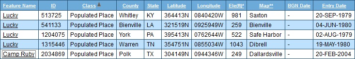
bb:

Here’s a theory. Lucky’s Magic Village use to be called Camp Rubi, and was a place for wee people to vacation or go to camp. It’s near the confluence of 1st and 2nd Streams. Should we name the streams?

Hucka D.:

All the colours of the rainbow. Wow!

bb:

Are we still talking about the plane? Or the camp?

Hucka D. (still pointing outside and looking at me, bb, now):

Rainbow.

—–

Related links:

http://www.tshaonline.org/handbook/online/articles/hrc12

Ideas: Camp Ruby was a logging camp, and the locus of logging activity around Rubi in Ancient times (pre-Linden). They logged the lower 3/8ths of Rubi and perhaps more. They logged the Sylver Forest in other words. Key quote:

The site was renamed Camp Ruby when the W. T. Carter and Brother Lumber Company established a logging camp there in 1926. According to local lore, A. B. Clayton was sent to select a good site; having chosen the heavily wooded area of Old Hope, Clayton renamed it after an acquaintance named Ruby Moore.

thicket

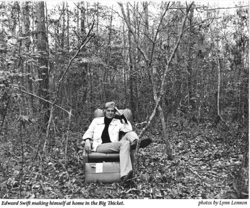
http://www.texasobserver.org/2806-out-in-east-texas-in-search-of-edward-swift/

Born in 1943, Swift spent his earliest childhood in the Big Thicket idyll of Camp Ruby, a small, faltering logging community tucked into the Great Piney Woods-from which his family would be flung by the Texas Forest Service into the mortal coil of nearby Woodville when Swift was 8 years old. Having visited the town, I find it difficult to believe anyone has ever grown up happily there, but Swift-an early balletomane twirling through town in a green wool skirt-certainly did not.

Like its courthouse, Woodville would remain, throughout Swift’s writings, a maddening model of backbiting, small-town repression, while Camp Ruby would be mythologized (in A Place with Promise and My Grandfather’s Finger) as an East Texas Eden-a green and easy home of hot melons and tall tales from which Swift would inherit his dissent and his story-telling craft. He offers this history of the Big Thicket:

Tyler County Court House

“The early settlers called it No Man’s Land, a hiding place for ne’er-do-wells of all descriptions. During the Civil War, the Thicket was a well-known refuge for pacifists and Jayhawkers, those who refused to fight for the South. It was also a haven for renegades, recluses, and religious fanatics … the wildest of dreamers, and the maddest of madmen. And although they were rabid individualists, they were similarly marked with loose tongues and poetic speech … They knew instinctively how to tell as well as how to enlarge upon a story while keeping it rooted in truth … that a story is a living thing and should grow with each telling.”

http://edwardswiftartist.com/#/the-artist/4527907027

ruby03

—–

Camp Rubi is now called Lucky’s Magic Village.

ruby04

Leave a comment

Filed under **VIRTUAL SL, Heterocera, MAPS, Rubi, Texas

Texas

Last night I wrote about Texas synchronicities related to VWX Town and its new Northside. I also posted the link to this blog entry on the Synchronicity Phenomena, since it relates to former board guru/leader Don Boulet. Tonight the wife and I watched an episode of The Big Bang Theory where main character Sheldon (another guru/leader) runs home to his mama in Texas after being embarrassed by friends and colleagues at the university he works. A flag of Texas covers one of the atomic particles in the segue to the Texan location in the episode, which I pointed out to the wife, who didn’t originally see it.* Now, just minutes ago, was looking up more info on Don and discovered this online work, the largest graphic I could find of one of his paintings, prominently displaying a Texas flag.

* You can view the Texas flag in the segue at 1:57 in this video:

texasbigbang
Also take a look at the resemblance to this marble picture added to my blog the night before viewing this episode.

In perusing pieces of the Synchronicity Phenomena’s archives, it seems that Don’s opinions about the supposed “real” or non-fictional Big Bang Theory were a bit jaded.

An additional possible synchronicity in all this is the appearance of a Firefly star (Summer Glau) in another episode of The Big Bang Theory, watched by the wife and I several nights previous to the Texan related one described above. The spaceport in Burnet sim, Second Life, which includes Joe’s Garage, seems based on this series.

Leave a comment

Filed under **VIRTUAL SL, Heterocera, MAPS, Texas

Return of Norum and SoSo West Galleries to VWX Town

In the past several days, I’ve created a “Northside” for VWX Town, composed of about 5 buildings including the 2 pictured below. These are Norum and SoSo West galleries, first seen in Pietmond, Otaki Gorge. Still within each is artwork from Julie Sadler and Mike Casey respectively. Original openings of these galleries are described here and here. Dr. Casey’s interview I conducted shortly afterwards is still found on my old blog as well. I need to re-read it again myself sometime soon.

Snapshot1207_001

Northside is basically made up of a 2048 parcel of land I decided to rent from Beetle Bailey. Unfortunately I do not have terraforming rights nor the ability to create linden plants, which are indeed handicaps. When Central and Westside go, certainly this part will be deleted as well, leaving only Southside on the other side of town eventually. Will this even come in two weeks? Or will it be delayed until October or perhaps beyond? I’m hedging toward the latter now still.

Check out my neighbor’s nice pics of Northside and VWX Town as a whole in the meantime!

As Veyot’s pictures also show, a general store (Clockwork) and a large tower I’m tempted to call the “Marble Tower” have also been rezzed in Northside.

Snapshot1207_002

Snapshot1207_003

I’ve basically done what I can with the place, and have absolutely zero prims left after this initial setup. I’m not sure that Northside will have strong personalities like Westside’s Cardboard (C.) Derek Jones to defend it from other town interests but we’ll see.

Snapshot1207_004
Marble Tower.

The land immediately north of Northside, where Baker stands below, is called *”Texas”*. Again this seems quite synchy, since SoSo West’s Dr. Casey now lives in Texas (Austin) and also the Marble Tower’s erection, coupled with recent landmark synchs in The Diagonal sim of Burnet, strongly brings to mind the recently deceased Don Boulet, former guru and leader of the Synchronicity Phenomena pack, and who also happened to reside in the Austin area — last in *Marble* Falls, which is in *Burnet* County.

Snapshot1207_005

And now it appears that Northside has a hot spring.

Snapshot1207_006

Note: Burnet is pronounced like “burn it”, with an emphasis on the first syllable.

Leave a comment

Filed under **VIRTUAL SL, Heterocera, MAPS, Texas

Diamond Too

The last Frank/Herman Park related post of this blog was created June 10, where I discussed further ramifications of finding a diamond shaped rock at Whitehead Crossing. All posts beyond this, up until (and including) this one, have instead dwelt on Wiltshire, England, where I spent the last 2 weeks of June. Amazing! But back to the point.

The last Frank/Herman Park related post I mentioned:

https://bakerbloch.wordpress.com/2013/06/10/diamond-beach-arkansas-beach-etc/

On June 9th, perhaps when I was preparing this last F/H post, a diamond shaped crop circle formed in a field just below the famous Alton Barnes white horse. Only today have I looked up more info on the crop circle, because on the surface, it looks quite manmade and artificial — an amateur effort, one could say. But maybe not. In contrast, the diamond shaped rock I found at Whitehead Crossing the week before was very regular and delineated. It was a true diamond, very similar to the one in the midst of the Arkansas flag I also reproduce in that 6/10 blog post.

But something else has come up in the meantime. The same field that gave us the diamond crop circle of 6/9 also produced, during my stay in England, another crop circle, which has some more surface oddities attached to it. This is the circle I’m talking about, which is a true circle on the perimeter. I was probably one of the first half dozen to dozen people to see this crop circle, which later morphed into a phase 2 (a certain percentage of crop circles have additional phases like this). Red Collie, who I’ve learned to trust to a large degree in discussions of crop circle meanings, has this to say about it:

http://www.cropcircleconnector.com/2013/Stantonstbernard2/comments.html

At Stanton St. Bernard on June 21, 2013, we saw a very clever field image which resembles a “reel of magnetic tape”:

Six angular numbers were coded into that “tape” in the order 2, 2, 3, 1, 3, 9 when reading inward from the outside. This scheme of coding is almost the same as that used at Barbury Castle on June 1, 2008 (see http://www.dailymail.co.uk), except now each angle of the spiral codes for a number using the formula n x 50o instead of n x 36o.

In light of the diamond crop circle – Whitehead Crossing diamond rock synchronicity mentioned above, I took a closer look at the articles and comments for the 6/21 circle occurring in the same field. At the end of the articles page is a broken English article pointing out a connection with a mysterious spinning statuette in the Manchester Museum, only a stone’s throw from the Alan Turing Building Red Collie mentions in his comments. The Alan Turing (connect to “turning”?) tour (“turn”?) Collie also mentions took place on June 18, 2013. The second statuette turning related post from Manchester Museum personnel comes from 6/20, where the time lapse video is introduced.

The mystery of the spinning statuette (II)

baileylamb03

About Egypt at the Manchester Museum

About Egypt at the Manchester Museum

The Manchester Museum houses over 16,000 objects from ancient Egypt and Sudan, making one of the largest collections in Britain and one with world-class holdings in a number of areas.

The mystery of the spinning statuette

When I first noticed that one of our Middle Kingdom statuettes (Acc. no. 9325) had been turned around 180 degrees to face the back of its case in our new Ancient Worlds galleries, I wondered who had changed the object’s position this without telling me. The Egyptians themselves would have appreciated the concern to make visible for passers-by the text on its back pillar – a prayer for offerings for the deceased.

What is very strange is that the statue has spun in a perfect circle – it hasn’t wobbled off in any particular direction.

http://thesaurus.com/browse/coffer

Main Entry:
coffer  [kaw-fer, kof-er] Show IPA
Part of Speech: noun
Definition: large box
Synonyms: case, casket, chest, exchequer, repository, strongbox, treasure chest, treasury, war chest

(continued in Diamond Too 02)

2 Comments

Filed under Crop Circles, Frank Park, MAPS, Texas, Whitehead Crossing, Wiltshire

Lynn County, Grassland, etc.

Grassland, Texas

My emphases.

The community was founded in 1888 and grew up around a ranch owned by Enos Seeds and his brother, Thomas.[2]

Grassland seems to be assoc. with the number 61 (same population for 3 decades):*

From the 1940s through the 1970s the population was recorded as 200. It had dropped to sixty-one by 1980. In 1974 Grassland still had two cotton gins, a store, and a station. The population was still sixty-one in 1990. The population remained the same in 2000.

It’s also Lynn County’s oldest community according to that same Texas Online Almanac article.

http://en.wikipedia.org/wiki/Frank_Herbert#Biography

Herbert began researching Dune in 1959 and was able to devote himself wholeheartedly to his writing career because his wife returned to work full-time as an advertising writer for department stores, becoming the breadwinner during the 1960s. He later told Willis E. McNeilly that the novel originated when he was supposed to do a magazine article on sand dunes in the Oregon Dunes near Florence, Oregon. He became too involved and ended up with far more raw material than needed for an article. The article was never written, but instead planted the seed that led to Dune.

http://www.duneinfo.com/giedi_prime/books/frank-herbert.aspx

Eye
ISBN: 0-743-43479-X

Eye features the startlingly original collaboration “The Road to Dune,” a walking tour of Arakeen narrated by Frank Herbert and illustrated by acclaimed British artist Jim Burns. Also included is an introduction by Herbert describing his personal feelings about the filming of David Lynch’s movie version of Dune; Herbert’s own favorite short story, “Seed Stock”; and tales from throughout his career, some never before collected.

http://oreilly.com/tim/herbert/ch09.html

As suggested in the discussion of Children of Dune, Herbert seems to subscribe to a kind of evolutionary ethic, which uses survival as a touchstone for evaluating species behavior. This ethic is also the subject of one of his most effective short stories, “Seed Stock” (1970).

A colony has been landed on an alien planet. It is dying. There is no return. The colonists are trying to reproduce Earth; they cannot understand why their efforts do not work. There is a strange force that warps embryos and seedlings so they do not flourish. The experts choose the most normal-born of the plants and animals to nurture, with no success. They cannot see (because it is unthinkable) that it is the seemingly most stunted and sickly of the plants and animals that are adapting. Kroudar, the laborer, listens with his body; he feels the different rhythm of life on his new planet. He does not try to maintain the old ways. He nurtures the new

—–

*
http://wiki.answers.com/Q/What_is_the_significance_of_601_in_The_Andromeda_Strain

In 4orrin1, the 601 here is directly overlapped with the number 61 of Giant Rat of Sumatra (36:39).

Leave a comment

Filed under Carrcass Artists, MAPS, Texas

More Whitehead related maps 01

Conjunction of Headsville with Bald Prarie in Robertson County, Texas indicates “bald head”. Nearby is White Creek and Heads Creek, just over line to north in Limestone County, but name conj. on map originally made me think this was a White Heads Creek. White Rock is below Headsville.

robertsontexas

https://bakerbloch.wordpress.com/2013/04/05/whitehead-x-ing-02/

I believe it relates to the first 2 rocks of the above, recent blog post here. The first picture is of a rock with a bald spot upon it. I think I’ll call this Head Rock now. Headville? The next picture is of a white rock, which I’ll call White Rock, which is near Headsville (and Bald Prarie) in Robertson County, Texas. These rocks of course come from the Whitehead Crossing region.

There is no article in the Texas Alamac for White Rock, Robertson County, unlike for nearby Headsville and Bald Prarie. However, this comprehensive almanac has a listing for a White Rock in Fannin County, which happens to be near a Petty according to the below stats, as White Rock in Robertson County is very near a Petteway (Pett—y + ewa in effect).

whiterocksintexas
White Rock population places in Texas. Notice that White Rock, Robertson County is on a Petteway topo map and White Rock, Fannin County is on a Petty map. This clued me in to their possible association.

Originally *here*, in this Maine location, I thought Whites Head (reverse of “White Heads”, Texas just discussed) was actually *one* word, Whiteshead, only corrected in my mind when I just checked in the GNIS database. There is a causeway of sorts, it seems, between this Whites Head, then, and Nautilus Island, which has come to symbolize Second Life’s Nautilus Island and probably Second Life itself.

monhegan04

4/11/13:

But getting back to the White Rocks of Texas, I noticed that the above mentioned White Rock near Petty is actually not in Fannin County but just over the east line in neighboring Lamar, about a mile and a 1/2 from Fannin County. So the GNIS database got this wrong, harkening back to the Herbert error discussed several months ago on this blog. But then in looking at that listing again, it’s interesting to note that a White Rock lies on a Whitewright topo map, and this particular White Rock is just beyond the *west* Fannin County line, in Grayson County in this case, about 4-5 miles in. Besides Whitewright we also have a White Mound near this White Rock, making a type of White Rock – Whitewright – White Mound triangle, with two more interestingly named population places within this established triangle, or Tom Bean and Kentucky Town.

Another perhaps odd thing here: White Rock in Lamar County, unlike the great majority of population places on the topo map involved, is marked with a black dot. So is White Rock in Robertson County. If we make White Rock, Lamar County the retrograde inversion of White Rock, Robertson County merging these two black dots, we find that each lies about 2 1/2 miles from their Petty (Lamar County) and Petteway (Robertson County) and in the same direction.

whiterocktexas02b

whiterocktexas01b

whiterocktexas01c
Retrograde Inversion of White Rock-Petty, Lamar County. You can kind of make an animation by toggling this with this.

There is one other Petty in Texas, in Lynn County on a topo map named New Home. This is also the only other Petty in the US as a whole according to the GNIS database.

petty01

From this map of part of Lynn County (lower right corner), we can see that Petty is (or was) near a place called Dune. Grassland exists to the east of Dune in this county still.

HockleyCountyTexas1940

The planet Dune became the New Home of Paul Atreides in Frank Herbert’s famous novel Dune, already discussed in connection with another map anomaly involving the name Hebert itself. Should White Rock-Petty be fitted into this overall mythology, still developing then? Or is this, ahem, a petty matter to contemplate.

175px-Lynn_County,_TX,_sign_IMG_1492

White Rock in Whitehead Crossing *points*. What is it indicating, if anything?

604ec08fdc1a4f153cf39bba8243a7e6
Ahem.

6 Comments

Filed under Frank Park, MAPS, Texas, Whitehead Crossing

Tidbits.

Water obelisk from Runescape:

http://misc.thefullwiki.org/Water_Obelisk

http://runescape.wikia.com/wiki/Water_Obelisk_Island

Compare:

—–

Looking up other Pietmond related names in atlases and came across SoSo Springs in Brewster County, Texas, more commonly known as Pena Blanco Springs. This appears to be the only significant place named Soso outside those directly connected with the Soso, Mississippi village. Quite amazing: a swimming pool formed from the spring waters was the landing spot of a 150+ lb. meteorite in 1946. Article here:

http://www.minsocam.org/ammin/AM32/AM32_354.pdf

INrnooucrtoN
As far as known, man has never constructed a device in which to trap
a meteorite falling to the earth. Had he done so, possibly he could not
have improved upon the swimming pool at the headquarters of the Gage
ranch about 9.5 miles southeast of Marathon in Brewster County, Texas.
This swimming pool received the Pefla Blanca Spring meteorite with a
violent splash at about 1:20 p.u. on August 2, 1946. The meteorite is
named from the spring which forms the swimming pool and which is
an historic landmark in the region. The exact location is longitude
103″7.l’ west longitude 3007.5′ north latitude. The unusual location of
the fall, the fact that the meteorite fell within a few hundred feet of
twenty-four people, and its unusual petrographic character appear to
warrant a fairly complete account….

http://www.encyclopedia-of-meteorites.com/meteorite.aspx?id=18786

—–

Hmmm, well we can go several directions in Pietmond storytelling with this one. First off, Obelisk Pond is the site of a *meteor or meteorite fall*, and the obelisk represents the meteor itself, or marks the location of the fall. Perhaps the falls behind the pond represent the fall of the meteorite. Like the Pena Blanco Springs meteor, our Pietmond meteor, perhaps nicknamed SoSo, fell into this body of water on the western edge of the village. Perhaps it created the pool in the first place. Or it could have been so large that the obelisk was made from it, or at least the obelisk *contains* the meteor or meteorite in some way. I also think back to a realtor I was renting from in Aotearoa who jokingly said to me that all these sinks in the area, including the Aoteaora Sink we were jointly staring into at the time, were perhaps created by meteors. Did the SoSo Meteor create the Pietmond sinkhole itself?? A possibility (!)

http://www.meteorite.com/meteorite-gallery/meteorite-pages/Pena_Blanca_Spring.htm

Might even have some kind of SoSo Meteor gallery based on the pictures in that page linked to above.

—–

http://en.wikipedia.org/wiki/The_Paradise_Syndrome

Meanwhile, over the two-month journey back to the planet, Spock works on the translation of the obelisk’s symbols. He theorizes the obelisk may have been placed on the planet as an “asteroid deflector” built by the ancient Preservers who are believed to have seeded the galaxy with humans, particularly groups that may have been in danger of dying out thousands of years ago. The asteroid deflector was designed to protect them in a high-risk star system. Spock concludes that the device has ceased to work properly. Spock determines that the only hope of saving the planet is to somehow activate the deflector. He eventually realizes that the symbols aren’t words but musical notes; a possible activation code of some kind.

So with this new tie-in, perhaps the obelisk of Pietmond likewise deflects asteroids, perhaps put in place after the original asteriods created the Sunklands sink. Or it may be a model of an original, larger meteor-deflecting obelisk. Words as musical notes…. interesting.

Also interesting is this conjunction of names in Washington state:

http://bakerblinker.wordpress.com/?s=stranger

1 Comment

Filed under **VIRTUAL SL, Jeogeot, MAPS, Pietmond-, Sunklands, Texas, Washington