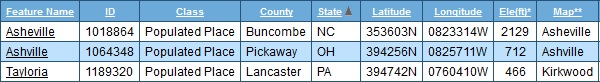
Category Archives: MAPS

MORE AFTERWARDS…00

snapshot8750_005

… Old Mabel finds out more about Roostre in returning to the Blue Feather Table Room. A *lot* more. She didn’t uncover the crucial Q109-R110 link, which Robot Steve would tell her about later on in a dream. But she, for instance, learned the origin of the name Muff-Bermingham. She thought back to the opening in Corsica that allowed Snowmanster to escape a firey death at the hands of Jerome T. Newton. It was all starting to add up. To something.

—-

EVEN MORE AFTERWARDS…

… “ARE YOU HAPPY?” Steve boomed down at her, still holding the poor clockwork ballerina in his metal claw. “I AM.”

snapshot8750_009

green-cube-smiley-happy-thumb10638827

birta

Leave a comment

Filed under **VIRTUAL SL, 0003, 0417, Arkansas, Heterocera, Rubi

Experiments in Soulcatching, 01

snapshot8577_004

snapshot8577_014b

Arnold and Betsy Layne.

snapshot_034b

Leave a comment

Filed under **VIRTUAL SL, 0003, 0204, Heterocera, Kentucky, MAPS, Rubi

Le Martian

plymouth

https://en.wikipedia.org/wiki/Le_Mars,_Iowa

Le Mars was platted in 1869, but no lots were sold until the Chicago and North Western Transportation Company arrived in 1879. According to town legend, CNW investor John I. Blair and a group of women arrived at the town, which was then called St. Paul Junction. Blair asked the women to name the town, and they submitted an acronym based upon their first names’ initials: Lucy Underhill, Elizabeth Parson, Mary Weare, Anna Blair, Rebecca Smith and Sarah Reynolds.[5]

Mars Beach in Hermania.

snapshot8282_007

I know where Karoz is newly arrived from now.

snapshot8281_010

snapshot8282_001
Boos 10: “The Martian”.

snapshot8177_008

merrie-melodies-laser-beam-marvin-the-martian

Speaking of Collagesity collages displayed in other locations…

Leave a comment

Filed under **VIRTUAL SL, 0002, Heterocera, Iowa, Maebaleia/Satori, MAPS, Rubi

Thoughts: Chesterton Etc. 02

lions_tigerville

“… reversed in Louisiana, with Lions the plural instead of Tigers. Instead it’s Tigerville, singular. In Chesterton yesterday there were 2 tigers on opposite sides of Wireway 61 from a lion. But at any rate, Wireway 61 resonates with Highway 61 which is, in turn, the Mighty Mississippi River itself.”

LOOK UP: How Miss. divides Lion and Tiger from each other, formerly joined at the hip. This separation also spells end of Oz rulership. Real Life begins. Birth.

Breaking of First Hoop in Chesterton at some point in the moving in of these wireways also parallels this end and new beginning.

U.S. Route 61:

https://en.wikipedia.org/wiki/U.S._Route_61

U.S. Route 49:

https://en.wikipedia.org/wiki/U.S._Route_49

At Jackson, U.S. Highway 49 shares an alignment with segments of Interstates 20 and 220 before turning northwest to Yazoo City. A split in the highway, rare in the U.S. system, begins here, with both routes heading into the Mississippi Delta, U.S. 49W serving the towns of Belzoni and Indianola, where it junctions U.S. Route 82 and its four-lane segment ends, while two-laned 49E serves Tchula before encountering U.S. 82 at Greenwood. Both routes continue north from 82 and are linked again at Tutwiler, Mississippi. Continuing northwest, the highway passes through an interchange with U.S. Route 61 as it enters Clarksdale. It is at Clarksdale that Highway 49 encounters “The Crossroads”, the legendary junction with State Street (an old alignment of U.S. 61) where the great blues musician Robert Johnson is reputed to have sold his soul to the devil.[6]

From Clarksdale, Highway 49 continues north toward its crossing of the Mississippi River, where it enters Arkansas near the town of Helena.

NOTE: Robert Johnson has come up in 2 separate ways recently in this blog. First, the Crossroads legend focusing on the 49-61 junction in Clarksdale has resurfaced through the crossed wireways of Chesterton, which have been identified with the 2 highways. Second, in Second Life, Quito has surfaced as a keyword in BoB (Birth of Bogato) LINK, and the Mississippi town of the same name (origin: unknown) was found to be one of 3 sites in Leflore County where Robert Johnson of 49×61 fame was reportedly buried in an unmarked grave.

Leave a comment

Filed under BIGFOOT, Blue Mountain, Louisiana, Mississippi

Middle

“Cool-i-o daddy. Glad you like it.”

BBloch:

I think it will be a great creation. More long term than Collagesity Proper.

Chester:

Right-o. Carrcassonnee is here. Can you dig it?

BBloch:

Yes, I can Chester. (noting Carrcassonnee’s open eye): Hi Carrcassonnee.

Carr.:

Hello Baker. Glad Carrcassonnee can keep you company while I was away.

BBloch:

You mean Chester.

Carr. (blushing?):

Yes. Do you wish to talk further about Chesterton? Tell me what you want to speak with tonight. Tomorrow.

BBloch:

Kevin Durant?

Carr.:

Oh, you know. He went with the titles. Like LeBron. Didn’t trust Westbrook. Wanted more a team environment. He’s no different from Shaq, from others in a different age. He’ll be fine. But Oklahoma City will suffer.

BBloch:

That’s a shame.

Carr.:

Westbrook will obviously leave now. Westbrook was always leaving, probably for L.A.

BBloch:

Golden State seems unbeatable[ now].

Carr.:

They are. But it will be fun to root for the opposite team. Especially LeBron’s team. Good he slipped another championship in before this juggernaut formed.

BBloch:

Yes. (pause) So what of Chesterton?

Carr.:

Is Oz in the middle still?

BBloch:

Um…

Carr.:

Find Oz.

—–

chesterton01

hamiltoncob

https://en.wikipedia.org/wiki/List_of_Six_Feet_Under_characters#Claire_Fisher

https://en.wikipedia.org/wiki/Clare_Fischer

Lauren_Ambrose_2000

1 Comment

Filed under **VIRTUAL SL, BIGFOOT, Blue Mountain, Heterocera, Indiana, MAPS, Rubi

BoB research

https://en.wikipedia.org/wiki/Quito,_Mississippi

Quito is an unincorporated community located in Leflore County, Mississippi. Quito is approximately 6 miles (9.7 km) north of Morgan City and 3 miles (4.8 km) south of Itta Bena along Mississippi Highway 7.

It is part of the Greenwood, Mississippi micropolitan area.

The cemetery of Payne Chapel in Quito is one of three locations held to be the burial place of blues musician Robert Johnson.

quito01

Quito *looks* like it was named for proximate Mosquito Lake but maybe not. Maybe it is named for the South American capital of Ecuador. The wikipedia article on the village doesn’t provide an answer. We do learn from the article that Alexandria is a variant name of this particular Quito, with the citation as James F. Brieger’s “Hometown Mississippi” published in 1980.

The 3 listed burial sites of legendary bluesman Robert Johnson, all in the same county of LeFlore:

https://en.wikipedia.org/wiki/Robert_Johnson#Gravesite

The exact location of his grave is officially unknown; three different markers have been erected at possible sites in church cemeteries burial outside Greenwood.

Research in the 1980s and 1990s strongly suggests Johnson was buried in the graveyard of the Mount Zion Missionary Baptist Church near Morgan City, Mississippi, not far from Greenwood, in an unmarked grave. A one-ton cenotaph in the shape of an obelisk, listing all of Johnson’s song titles, with a central inscription by Peter Guralnick, was placed at this location in 1990, paid for by Columbia Records and numerous smaller contributions made through the Mt. Zion Memorial Fund.
In 1990, a small marker with the epitaph “Resting in the Blues” was placed in the cemetery of Payne Chapel near Quito, Mississippi, by an Atlanta rock group named the Tombstones, after they saw a photograph in Living Blues magazine of an unmarked spot alleged by one of Johnson’s ex-girlfriends to be Johnson’s burial site.[45]
More recent research by Stephen LaVere (including statements from Rosie Eskridge, the wife of the supposed gravedigger) indicates that the actual grave site is under a big pecan tree in the cemetery of the Little Zion Church, north of Greenwood along Money Road. Through Stephen LaVere, Sony Music has placed a marker at this site, which bears LaVere’s name as well as Johnson’s.

An interviewee in the documentary The Search for Robert Johnson (1991) suggests that owing to poverty and lack of transportation Johnson is most likely to have been buried in a pauper’s grave (or “potter’s field”) very near where he died.

TombstoneRobert_Johnson

Quito, MS and Quito, TN are both near an Egypt.

1 Comment

Filed under **VIRTUAL SL, Lower Austra, MAPS, Mississippi, Nautilus

Bigfoot Early June 01

A possible significant find in Bigfoot along the road almost encircling the Bigfeet Swamp: the head of a wooden golf club. Remembering that the original object found in Bigfoot Center — and which the very successful toy happening from last fall was built around — was a golfing iron. Is Bigfoot telling me now that it is being upgraded from an iron (middle game) to a wood (long game)?? I’ve passed this spot many times and not seen the wood head until this day. I definitely think the find has meaning. Bigfoot *is* being upgraded.

The wood head was also found at almost the exact opposite side of Bigfeet Swamp from Bigfoot proper and its own golf club. The two clubs oppose each other in some fashion. And I also think the UMAPS version of Georgia (state) is being inferred, with its own iron and wood golfing references. Bigfoot is also clearly marked in UMAPS in Texas, via the only US Bigfoot. And my Bigfoot also has close ties to Iron County, Missouri.

IMG_1978smaller

The wood head lies near the top of this somewhat mysterious set of apparently now forgotten and unused “stairs” leading up to Bigfeet Swamp from Leola Creek.

IMG_1981smallest

Orange-y (Chester”? Cheetah?) Brook or Stream to the north of Bigfeet Swamp, once more. As I’ve found out recently, you can see the head of this stream from Bigfoot Center.

IMG_1992smaller

Another strange spring outlet leading down from the Plateau of Raw Art, just like the Bigfoot stream but further north and not emptying into a pool/swamp this time. Although Orange-y Stream is nearby, it also doesn’t empty directly into it. Actually, there’s been little flow of water within this culvert when I’ve visited. It’s difficult to see (and take photos of) during summer months because of all the surrounding brush.

IMG_1997smaller

Looking up through an avenue of green from the culvert toward the Plateau of Raw Art.

IMG_1999smaller

There are a good number of these kind of rocks around the culvert.

IMG_2000smaller

Another Bigfoot rock. There are many.

IMG_2008smaller

3 photos taken at the Plateau of Raw Art as I made my way back to my car this day.

IMG_2009smaller

IMG_2020smaller

IMG_2029smaller

1 Comment

Filed under BIGFOOT, Blue Mountain, Georgia, MAPS

Bigfoot 05/10/16

I’ve been calling the more clear place on Second Road Secondary for now, but I may change the name to Chester, partially after orangey Chester the Cheetah, mascot for world famous, multi-billion dollar corporation Cheetos, most noted for their cheese puffs. My favorite snack food of all time (just kidd’n). Anyway, these 3 lined up, orange-ish mushrooms reminded me of the kind of similarly colored 3 Chesters now in Newtown Hollow Square, Collagesity.

IMG_1757smaller

Chester residence?

IMG_1758smaller

IMG_1760smaller

There are also some interesting “native” rocks in the immediate area. I may make a detailed map of all this soon enough. I’ll probably return to Bigfoot this weekend.

IMG_1761smaller

When I googled “Cheetahs” + “high school” in an image search, the below came up near the top of the list. Lacrosse again, resonant with the same sport ball in the Chester region. Kind of synchy, no?

2d78f462c6c6c6c4eb7a660a6ec60d61

https://en.wikipedia.org/wiki/Plainfield,_Illinois

Plainfield is identified as the oldest community in Will County because the earliest settlement of Walkers’ Grove was established on the banks of the DuPage River by 1828. However, the actual Village of Plainfield was platted immediately north of Walkers’ Grove in 1834 by Chester Ingersoll. The separate community of East Plainfield was platted in June 1836 by James Mathers who began selling lots in July 1836.

And Chester there again (Plainfield’s founder/platterer). Plainfield is also pretty near Joliet and Romeo(ville), in a *Will* County. It’s also said to be, per wikipedia, the oldest community in this county.

More area rocks:

IMG_1769smaller

IMG_1770smaller

Bigfoot greenery.

IMG_1790smaller

A nearby, painfully yellow softball surrounded by poison ivy.

IMG_1792smaller

Breeze block. Now I just need a bit of old bone and I can fantasize up anything (Black Books reference).

IMG_1794smaller

Nearby, additional Bigfoot rocks:

IMG_1795smaller

Leave a comment

Filed under BIGFOOT, Blue Mountain, Illinois, MAPS

More Circles

Although what I’m calling the Middletown Circle is still the main one of its type, I’ve created others in the area recently, like the nested circles below surrounding Future Home and including First/Prime. For now I’ll just let the pictures tell the story, except to say that the curves of the Greenway provide the beginning point…

middletown03b

… as it does for these 3 just south…

middletown04

… and also these 2 just south of the above, with the upper one surrounding and including dreamy Hemp Hill LINK. There are no exact relationships I can identify between any of these circles. All are different sizes, for instance, except in one case.

middletown05

Then returning to the area of the Middletown Circle, I’ve created another circle fairly close to it which contains the natural area I’ve termed Goth Hill in this blog before, which may earn its own subcategory sometime. Right now I’m lumping all things Middletown just under a general heading.

middletown06b

Going back to the concentric circles of the first picture, we can include this now… Bill Mtn., if you recall, is a place of contact in Blue Mountain. Is Middletown’s Bill Mtn. placemarked above the same? Time will tell. Time will tell.

bullmountain02e

Leave a comment

Filed under MAPS, Middletown, North Carolina

Ash(e)ville…

Asheville (3):

asheville01

Because of its variant name of Ash(e)ville, Ashville PA may be most connected to Ash(e)ville NC, as discussed here a bit:

the 2nd Ashville, and another Apocalypse Now connection?

My Ash(e)ville may earn the nickname of Little Chicago through this. It has a very large downtown for a city its size. And then for other reasons I change its name to Middletown later on. Chicago is in the middle of the US, in the Great Lakes region.

Let’s turn to Ashville, then, and the kindred to Ashville PA in a more direct, surface way:

ashville01

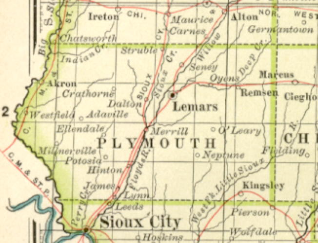
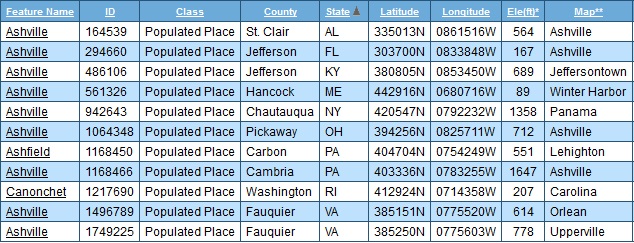
Along with Ashfield PA, Canoncet RI is the only listed variant of Ashville, and the only one not containing the root word “Ash”. It is located in a county (Washington) already mentioned in the blog here in connection with triple state names:

map happenings 03

Carolina and Wyoming are also both in Washington County in Rhode Island, and so both make types of triple state name as well (Carolina, Washington, Rhode Island and Wyoming, Washington, Rhode Island). Largest “Ashville”, by far (Ash(e)ville/Middletown), is located in (North) Carolina.

Wyoming in Iowa County in Wisconsin state probably makes up the most profound or central triple state name of this kind, and may additionally highlight Wyoming RI here.

It brings to mind this: Are there any towns in counties and states of the *same* name (as opposed to all different names). This would be a triple state redundancy, then, and the opposite of all three having different names.

The only two that come close involve large cities:

1) *Part* of New York City (basically Manhattan) lies in New York county in New York state.
2) *Most* of Oklahoma City lies in Oklahoma county in the state of Oklahoma.

—–

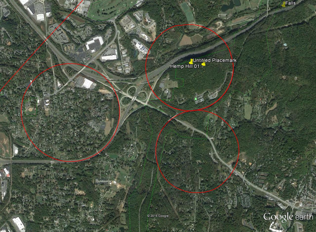
Returning to Ashville OH, we can perhaps extend our range through understanding that a city named Circleville is the county seat and largest burg of inclusive Pickaway County.

pickaway_county_ohio
Ashville and Circleville in Pickaway County, Ohio

Circleville, true to its name, was originally designed as a circle. Story here:

http://pickaway.com/history.html

originalphoto

Circleville was unique among early American towns, built to conform to a circular prehistoric earthworks. When Pickaway County was formed in 1810 there were no existing settlements that seemed suitable for a county seat. Therefore, a new town was laid out within the ancient’s “circle” on the high bank east of the Scioto River. It’s streets radiated from an octagonal courthouse in the center of the circle.

Two communities existed near Circleville prior to its being laid out as the county seat. Jefferson and Livingston ceased to exist several years after Circleville was designated the seat of government in 1811. When the Ohio Canal reached Circleville, the shape of the town within the circle proved to be a hindrance, and in 1838 a group of enterprising businessmen began to “square the circle”. Over the next 20 years the job was accomplished and all traces of the ancient earthworks disappeared.

circleville

Circleville2

The concept of “squaring the circle” spoken about in the above excerpt has also come up recently in this blog in connection to the Moon of the Moon, except there the process was reversed: Jack and Lily *circled* (or “sphered”) the square (or “cube”) that was the Moon of the Moon by creating a world ocean and introducing omni-directional gravity.

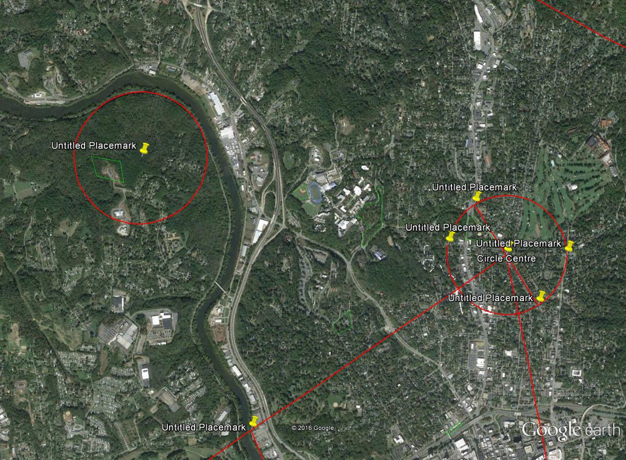
And in a more limited way I’ve done a similar thing with Ash(e)ville/Middletown through what I call the Middletown Circle, introduced on this blog back in Winter 2014/2015. This is also the point where I decided to rename Ash(e)ville as Middletown, invoking what appears to be an older matrix.

Ashville Circle 01

ashvillecircle03
Middletown Circle

Leave a comment

Filed under MAPS, Middletown, North Carolina, Ohio, Rhode Island